
Plate Tectonics
Discover the fascinating world of plate tectonics and continental drift. Learn about Pangaea, VLBI measurements, and uncertainties in geodesy. Explore how scientists track the movement of Earth’s plates using advanced technology. Join us in unraveling the Earth's geological puzzle!
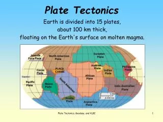

Plate Tectonics
E N D
Presentation Transcript
Plate Tectonics Earth is divided into 15 plates, about 100 km thick, floating on the Earth's surface on molten magma. Plate Tectonics, Geodesy, and VLBI
Do the continents fit like a puzzle? The West African coastline and the East coast of South America Northeast Africa and Arabian peninsula © F-Secure Corporation Plate Tectonics, Geodesy, and VLBI
According to Tectonic Plate Theory; • Once all continents were compressed into one. Pangaea("all lands") • Over time they drifted apart into their current positions. • Try fitting it yourself (Hit the green button) Plate Tectonics, Geodesy, and VLBI
How do scientists measure continental drift? Radio telescopes at different sites investigate the motion of the Earth’s tectonic plates. See more Very Long Baseline Interferometry Plate Tectonics, Geodesy, and VLBI 4
How does VLBI work? • Two radio telescopes are looking at the same quasar. • Incoming radio wave signals are tagged with an atomic clock. • Signal arrival times at the two telescopes are compared. • 4. The distance between them is calculated. Plate Tectonics, Geodesy, and VLBI
Radio Telescope Plate Tectonics, Geodesy, and VLBI
Continental Drift between North America and Europe Picture by Axel Nothnagel Westford, Massachusetts Wettzell, Germany Plate Tectonics, Geodesy, and VLBI
Simple but Precise • What are the limits and uncertainty of VLBI measurements? • How may they be resolved? Westford,, MA USA Wettzell, Germany Plate Tectonics, Geodesy, and VLBI
Errors, errors, errors!!! • No matter how good you are…there will always be errors. • Every measurement has uncertainties and errors (unfortunately). • The question is… How to deal with them? Plate Tectonics, Geodesy, and VLBI
Uncertainty in the VLBI Measurements (Westford to Wettzell) Plate Tectonics, Geodesy, and VLBI
Continental Drift between North America and Europe C C Westford, Massachusetts Wettzell, Germany Plate Tectonics, Geodesy, and VLBI


