Download

1 / 40
400 likes | 499 Views
Learn about climate factors like temperature and precipitation, climate zones such as tropical wet and highland, and various vegetation regions including rainforests and deserts. Understand how latitude, wind, currents, water proximity, and elevation affect climate patterns.

E N D
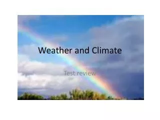
Climate is the condition of the atmosphere over a long period of time. Climate
What is the difference between a desert and a tropical rainforest? What is the difference between Antarctica and a desert? Think! If you said temperature and rainfall (precipitation) you are right!
Three characteristics of climate are: Temperature Precipitation Seasons Climate
Why do some places get more or less rain? Why are some places hot and some places cold? Why do some places have seasons that are equal in length and some places don’t? Think!
Four factors or elements that affect climate are: Latitude Wind Currents Proximity to Water Elevation Climate
Temperature is hotter or colder at different latitudes because the earth is tilted on its axis at 23.5° in relation to the sun and it revolves around the sun. The tilt of the earth causes different amounts of sunlight to hit the earth at different times so we have seasons. Latitude
The Tropic of Cancer and Capricorn mark the farthest points north and south that receive the direct rays of the sun. This is why the area near the equator is very warm all year. Latitude
When the direct rays of the sun hit the Tropic of Cancer or Capricorn it is called a solstice. When the direct rays of the sun hit the equator it is called an equinox. Latitude
Wind and ocean currents distribute the sun’s heat through convection, the transfer of heat in the atmosphere through upward motion of the air. Wind Currents
Areas near the ocean tend to have a milder winter and a cooler summer. Ocean currents are like rivers in the ocean. Warm water flows away from the equator and cold water flows toward the equator. Proximity to Water
Some important ocean currents are: The North Atlantic Current; this ocean current warms Western Europe. The East Australian Current The Gulf Stream Proximity to Water
Elevation influences temperature. As you go up in elevation the temperature becomes colder because the atmosphere is thinner. Areas with very high elevations can have vegetation similar to the arctic. Elevation
Some areas with high elevations are: The Plateau of Tibet in Asia Countries in the Andes Mountains such as Bolivia, Chile, and Peru Switzerland in the Alps Elevation
Climate zones are classified by temperature and precipitation. Biome refers to the climate of an area and the types of animals and vegetation that are found in that area. Climate Zones
Low Latitudes - Tropical Wet and Tropical Wet and Dry. Middle Latitudes - Mediterranean, Humid Subtropical, Humid Continental, Marine West Coast. High Latitudes - Subarctic, Tundra, Icecap Varies - Semiarid, Arid, Highland Climate Zones
The types of plants that grow in an area are dependent on three things: temperature, precipitation, and amount of sunlight. Vegetation Regions
Deserts are based on precipitation. There are hot and cold deserts. Some hot deserts are: The Sahara, The Namib, The Atacama, and The Gobi. Antarctica is actually a desert because it gets very little rainfall. Deserts
Grasslands are classified by temperature and precipitation. Grasslands don’t receive enough rain for trees to grow but they can vary in temperature. Grasslands
Savanna - Africa Llanos - Colombia and Venezuela Cerrados - Brazil Tropical Grasslands
Prairie - The United States and Canada Pampas - Argentina Steppe - Central Asia Temperate Grasslands
Tundra - The Tundra is a flat treeless plain located in the far north on the coast of Alaska, Canada, and Russia. The Tundra has short grasses, a few shrubs, mosses, and some flowers. Underneath the tundra there is permafrost, permanently frozen subsoil. Cold Grasslands
Forests near the equator have more broadleaf trees and the leaves are larger because the area receives more sunlight. Forests in the high latitudes have more coniferous trees because they grow better with less sunlight. Forests
Rainforests are found in tropical wet climate zones in the low latitudes. What countries do you think have rainforests? Rainforests A. Brazil - Amazon Rainforest B. Congo C. Indonesia D. Most of Central America
The Taiga is a large coniferous forest that covers most of Siberia. In Canada and Alaska coniferous forests are called boreal forests. The Taiga is characterized by cold winters and short summers. Taiga
Middle latitude forests have a mix of coniferous trees and deciduous trees. Deciduous trees are broadleaf trees that lose their leaves in the winter time. Middle Latitude Forests
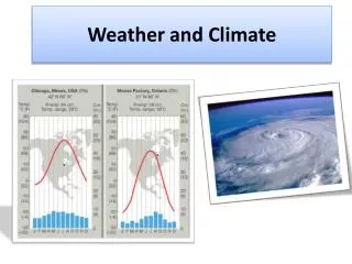
A climograph is a graphical representation of temperature and precipitation for a location. By comparing climographs we can understand differences in climate from one location to another. Climographs