
7.8 ความสัมพันธ์น้ำท่ากับน้ำฝน
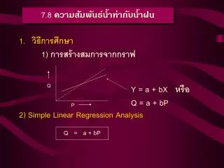
7.8 ความสัมพันธ์น้ำท่ากับน้ำฝน. วิธีการศึกษา 1) การสร้างสมการจากกราฟ 2) Simple Linear Regression Analysis. Q. Y = a + bX หรือ Q = a + bP. P. Q = a + bP. 3) Multiple Linear Regression Analysis

7.8 ความสัมพันธ์น้ำท่ากับน้ำฝน
E N D
Presentation Transcript
7.8 ความสัมพันธ์น้ำท่ากับน้ำฝน • วิธีการศึกษา 1) การสร้างสมการจากกราฟ • 2) Simple Linear Regression Analysis Q Y = a + bX หรือQ = a + bP P Q = a + bP
3) Multiple Linear Regression Analysis P1 = Rainfall amount (mm.) P2 = Antecedent Rainfall (mm.) P3 = Antecedent Soil Moisture (Pi = rainfall intensity , Duration , Antecedent time ) 4) Regression Analysis โดยใช้ข้อมูล Water Year Basis 5) Free Land Curve……..Trial an error Q = a + b1P1 + b2P2 + b3P3 + … + bnPn
2. ผลงานการศึกษาความสัมพันธ์น้ำฝนกับน้ำท่า - ปริมาณน้ำในประเทศไทยมี 800,000 ล้านลบ.ม. แต่มีปริมาณน้ำท่า เพียง 200,000 ล้านลบ.ม.เท่านั้น - ปริมาณน้ำท่าต่อหน่วยพื้นที่ในลุ่มน้ำขนาดเล็กให้ปริมาณน้ำท่าสูง กว่าลุ่มน้ำขนาดใหญ่ - ในพื้นที่ต้นน้ำลำธาร (ป่าดงดิบเขา) ประมาณ 65 เปอร์เซ็นต์น้ำฝนหรือ 1,500,000 ลบ.ม./ตร.กม. พื้นที่ราบในพื้นที่ลุ่มน้ำตอนล่าง ประมาณ 250,000 – 400,000 ลบ.ม./ตร.กม. ในขณะที่ทางพื้นที่ภาคอิสานให้ น้ำท่า 15-30 เปอร์เซ็นต์ของน้ำฝนเท่านั้น - ปริมาณน้ำท่าที่ไหลของภาคเหนือ ในช่วงมีฝน (wet period) และ แล้งฝน (dry period) 80 และ 20 เปอร์เซ็นต์ของน้ำท่าซึ่งภาคอิสาน มีค่า 95 และ 5 เปอร์เซ็นต์
7.7 วิธีการแยกกราฟน้ำไหล (Hydrograph Separation) 1. Fixed Base Length Method- การเพิ่มปริมาณน้ำท่า เป็นการเพิ่ม Direct flow แทบทั้งสิ้น ผลของการไหลลงไปขังในลำห้วย ลำธารยังมีผลต่อการยับยั้งการซึมน้ำออกสู่ลำธารของ Groundwater Flow 2. Straight Line Method- การเพิ่มของปริมาณน้ำท่า เป็นการเพิ่มเฉพาะส่วนที่เป็น Direct Flowเท่านั้น 3. Variable Method - การเพิ่มปริมาณน้ำท่าเป็นการเพิ่มทั้งปริมาณ Direct flow และ Groundwater flow เป็นการกำหนดปริมาณน้ำใต้ดินซึ่งเป็น Base flow เป็นวิธีการที่นิยมใช้กันมากที่สุด
Point of inflection 3 2 1 ภาพแสดงวิธีการแยกกราฟน้ำไหล ทั้ง 3 วิธี
ตารางแสดงการแยกกราฟน้ำท่าโดยวิธี Fixed Base Length Method (FBL), Straight Line Method (SL) และ Variable Base Method (VB) Time ToTal Flow Baseflow (Cms) Direct Flow(cms) (cms) FBL SL VB FBL SL VB 1 T1 F1 S1 V1 T1-F1 T1-S1 T1-V1 2 T2 F2 S2 V2 T2-F2 T2-S2 T2-V2 3 T3 F3 S3 V3 T3-F3 T3-S3 T3-V3 . . . . . . . . . . . . . . . . n Tn Fn Sn Vn Tn-Fn Tn-Sn Tn-Vn หมายเหตุ Time เป็นเวลาอาจมีหน่วยเป็น นาที ชั่วโมง หรือ วัน ก็ได้