Download
1 / 4
40 likes | 57 Views
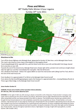
Pines and Mines 48 th Paddy Pallin Winter 6 hour rogaine Sunday 19 th June 2011. To Berrima/ Mittagong. HH. To Goulburn. Directions to Site.

E N D
Pines and Mines 48th Paddy Pallin Winter 6 hour rogaine Sunday 19th June 2011 To Berrima/ Mittagong HH To Goulburn Directions to Site Turn off the Hume Highway onto Belanglo Road, signposted to Gordon VC Rest Area and to Belanglo State Forest. This road is also listed on many maps as Bunnigalore or Bunnygalore Road Travel along Belanglo Rd for approx8.5 km, past the State Forest HQ on your left and Meredith Park (large cleared farm area) also on your left. Towards the end of the cleared area, Belanglo Road veers sharply right while a private track continues straight ahead. Take the right turn and then immediately the road splits. Take the left branch. This is Brethren Point Road – follow it for approx 800m to reach the intersection with Calling Coal Fire Trail, which is the start of the hash house site From Goulburn it is approximately 57 to 58 km to the Belanglo State Forest turnoff From where the Berrima/Mittagong bypass rejoins the freeway it is approximately 5km , crossing Medway Rivulet at Three Legs’o Man bridge, to the Belanglo State Forest turnoff. James Heather Gordon VC GORDON, Private James Heather 2/31st Australian Infantry Battalion, AIF 10th July, 1941 near Jezzine (Djezzina) SyriaCITATION: On the night of 10th July 1941 during an attack on Greenhill, north of Djezzine, Private Gordon’s Company came under intense machine-gun fire and its advance was held up. Movement even by single individuals became impossible, one officer being killed and two men being wounded in the effort to advance. The fortified enemy machine-gun position which brought the two forward platoons to a halt completely covered the area occupied by our forces. Private Gordon, on his own initiative, crept forward over an area swept by machine-gun and grenade fire and succeeded in approaching close to the post; he then charged it from the front and killed the four machine-gunners with bayonet. His action completely demoralised the enemy in this sector and the Company advanced and took the position. During the remainder of the action that night and the following day, Private Gordon, who has throughout operations shown a high degree of courage, fought with equal gallantry. (London Gazette: 28th October 1941.)
Traffic Management For the event, we are implementing a one way traffic system to try to minimise the risk of people injury or vehicle damage. During peak traffic periods (late Saturday afternoon and early Sunday morning) there will be people directing traffic. Outside of these times, please stick to the traffic restrictions. Bunnygalore Road and Brethren Point Road will be being used by residential, quarry and logging traffic during the event. When parking ensure that your vehicle is clear of the track. Calling Coal Fire Trail Two Way One Way HH Two Way Bunnygalore Road One Way Two Way Emergency egress If Bunnygalore Rd blocked Emergency egress Brethren Point Road Two Way Emergency Evacuation The most likely reason for an evacuation would be a bushfire. Should the hash house site need to be evacuated for any reason, the preferred route will be back out the way you came in, on Bunnygalore Road to the Hume Highway. The emergency assembly area will be the Gordon VC Rest Area. Please do not leave this area without ensuring that your group or team is marked off as out of the danger area. If a fire occurs while you are out on the course, stay well clear of any burning areas – upwind where practicable. If it is safe to do so, work eastwards which should take you clear of the pine forest and into farmland. Then head to Bunnygalore Rd and to the Gordon VC Rest Area assembly point. Should the Bunnygalore Rd route to the east be unavailable for any reason, then egress will be along Brethren Point Road to the west. This route crosses private land with numerous locked gates. Any evacuation via this route will be supervised by Forests NSW.
Hash House Layout No Parking/Camping Overflow Parking Camping Red Arm Creek Fire Trail Sunday Day Parking Calling Coal Fire Trail Admim Hash House Brethren Point Road Notes: The area we are using is not the regular designated camp-site for Belanglo State Forest – that is at Daley’s Clearing. Forests have allowed us to use this area because we have a previous “good tenant” reputation in this and other state forests (that we’d like to keep) and also the location helps us and them with traffic management over the weekend. We have been asked to try to keep trampling of the understory, particularly tree saplings, to a minimum. No on-ground fires are allowed. Please bring your own wood if you are bringing a fire basket. So please keep to the assigned areas. Camping and parking space will be moderately tight, so snuggle up to your new neighbours. You should have at least three things in common to talk about! Camping, rogaining, and */&^@) officious rogaine organisers, of course. The toilets are there to be used – for both No 1’s and No 2’s! Belanglo is very heavily utilised and doesn’t deserve to be covered in sewage or festooned with loo paper.
Belanglo Forest Walks – keep in mind for when you come back ... Belanglo State Forest is a commercial exotic pine forest with extensive peripheral native forest. The forest contains many trails suitable for walking and bird watching. Numerous tracks exist that are not marked on the topographic maps. Additionally, track signage is poor and many signs are missing or lying on the ground. Make sure you have a compass and/or GPS and map when exploring this area. Be very aware of fire danger during summer months. This a great birding location for dry woodland birds (see below) and during spring large flocks of Yellow-tailed Black Cockatoo (up to 120) can be observed.1. The western boundary walk, a 10 km loop. Moderate with two 500m steep sections. Follow the Bunnygalore Rd. for about 4.5 km until you see the Western Plantation Rd. on your right. Follow this past two cross-roads and turn left at the third, follow this west until you come to the fire break which separates the pine forest from the eucalypt woodland. Turn right and park your car at the next intersection, a track that leads into the eucalypt forest. From hereon its 4WD or walking. Follow the track west down a slight incline to the next intersection and turn right, follow this in a northerly direction for 2km, pass through open woodland with some magnificent sandstone bluffs before you ascend an incline to the near the corner of the firebreak and pine forest (Dalys Rd/ Firebreak Rd). At this intersection is a small memorial commemorating the fate of several backpackers who were murdered in the forest by a serial killer in the early 1980s. From here continue north for about 400m until you come to an unsigned sandy track that heads west (Longarcre firetrail). Follow this through woodland for 1.7km when you come to a lookout before the first steep descent. During the steep 400m descent admire the conglomerate and shale lenses in the cliff face. At the bottom of your descent is Longacre Ck., which is usually dry. Tall smooth-barked gums with blady grass make for a very pleasant rest area. After resting walk up the moderate to steep 700m ascent before emerging onto Bunnygalore Rd. Turn left (south) and walk along the forest roadside for 2.6km and turn east (left) onto the unsigned Belanglo Plateau fire trail. Follow this in an easterly then northerly direction, crossing the upper reach of Longacre Ck along the way. After about 4.4km you come to an intersection, turn right up the incline and you should be back at your car. This is one of my favourite woodland birding areas. Scarlet and Flame Robins are always present, and often there are Grey Currawong about. Other goodies you can expect include Rockwarbler, Emu, Spotted Quail-thrush, Leaden Flycatcher, Common Bronzewing, Wedge-tailed Eagle, Restless Flycatcher, Buff-rumped Thornbill, Speckled Warbler, Brown Treecreeper, Eastern Rosella, White-eared Honeyeater, White-throated Gerygone and if you’re lucky Painted Button-quail. 2. The northern boundary walk. 6.5km. loop, easy to moderate grade. Follow Bunnygalore Rd. from the Hume Highway for 4km turning down Daly fire trail. When you come to a T intersection turn left and follow this to the end and park at the backpackers memorial. Walk back along Daly fire trail for 800m until you reach an un-signed fire trail on your left (Miners Despair trail). Head north for 200m then turn right (east) onto Maritime Pine trail. Follow this for 1.1km and turn left onto Cave Tree fire trail, which turns east, then north, then south, then west. Once your heading west (use compass) follow the trail for about 1km before you veer north around a bluff, then west again, descending slightly and crossing two creeks with wooden log bridges. Ascend a slight rise to an intersection. You will have walked 3km along this fire trail. At the intersection veer west along Miners Despair firetrail for another 700m or so until you come to an intersection that crosses a creek. Continue 250m along the track that heads north (don't cross the creek). This terminates at a lookout overlooking a beautiful fern-clad gully and small waterfall. Notice the coal seam here. Retrace you route back to Tree Cave fire trail (900m) but head south (right) at the T intersection along Miners Despair trail for 700m. This brings back to Daly fire trail, turn right and its 650m back to your car. Birding is excellent with a similar range to that found along the western walk (above) and you may add White-winged Chough, Striated Pardalote, Rufous Whistler, Noisy Miner, Leaden Flycatcher, Rufous Whistler, Rockwarbler, Pilotbird, Superb Lyrebird and Horsefield's Bronze-cuckoo. 3. Miners Despair loop 4.5 km. Park your car at the backpackers memorial cairn as described above for the western loop (1). Head east back along Daly Rd. for 400m and turn left down an un-signed fire trail for 100m and turn right at intersection onto Maritime Pine fire trail and proceed for 600m then turn left (north) onto Miners Despair fire trail. Follow this for 400m to a T intersection. Turn left (west), [right is Tree Cave fire trail]. Continue along Miners Despair trail for 500m until you come to an intersection next to a creek crossing. Veer to the right for 250m along this track which terminates at a lookout over a fern-clad valley and small waterfall. Note the coal seam here. Retrace your route for 200m to the creek crossing and head west over the creek. Follow this track for another 1.3km until you reach an intersection with Morrice Creek fire trail. Turn left (south) for 800m back to your car. Birding is very good along this track with similar species to that found in northern boundary route above. 4. The southern boundary loop 4km. Drive west along Bunnygalore Rd. for just over 3km until you encounter Cherry Tree Hill Rd. on your left. Follow this south, and then turn west. Along this section of forest boundary are some very old snappy gums and lots of fallen timber, look for White-winged Chough, Eastern Rosella, Flame Robin, Grey Currawong and Brown Treecreeper. Continue west around the boundary trail skirting the private property, past a large farm dam which is good for common waterbirds and occasionally Black-fronted and Red-kneed Dotterel. Eastern Rosella and Noisy Miner are common here. Park here and walk west for 500m then find the track that heads south through scribbly gum woodland past the Link fire trail into stringybark forest. Walk south for another kilometre through forest until you reach the track end and nice lookout over Black Bobs Creek. Return the way you came until you reach the Link fire trail which heads west through a small gully for 500m before you emerge at the boundary of another private property. Walk north for 50m then turn east along the boundary fire trail over rocky track for a kilometre back to your car. Good general birding with Eastern Yellow, Rose and Scarlet Robin, Yellow-faced and Crescent Honeyeater, Variegated Fairy-wren, Spotted Quail-thrush and Grey Butcherbird being some species that may be encountered.5. Red Arm Creek fire trail, 10km loop. A spectacular section of forest of generally easy grade with a steep 500m descent and a steep 500m ascent. From the Hume Hwy, travel west along Bunnygalore Rd. through the pine forest and past private property for approx 6.5km until you come to a right hand bend. Continue north for a kilometre (follow the Bunnygalore sign) and park at the intersection with a track on your left. This is Calling Coal fire trail on the topographic map, but it's not sign posted. Head in a southerly direction for a kilometre through forest with lots of casuarina (watch for Glossy Black Cockatoo), then turn west for 500m then you should reach an intersection that heads north along a sandstone and shale ridge. This is Red Arm Creek fire trail. Follow this for 3.5km through actractive rugged sandstone woodland until you reach the very steep 500m descent. At the bottom you are next to Red Arm Creek. Walk west for 800m until you come to cleared private property (Rockleigh) where you may see Emu grazing, Eastern Rosella and Common Bronzewing. Return the way you came, past the fire trail you descended, across the normally dry creek bed then begin the moderately steep 700m ascent. At the top you pass an old quarry which is now a pistol club (so you may hear gun shots)! Continue along the road, veering to the right at the next intersection and past another disused quarry for 2.8km when you should be back at your car.