Download
1 / 54
540 likes | 705 Views
THE INSIDE STORY: OCEAN CIRCULATION by Robert Perry. DISCLAIMER: The images, maps and diagrams in this presentation were taken from the public domain on the world wide web. Any privately owned images not available for this non- commercial, educational

E N D
THE INSIDE STORY: OCEAN CIRCULATION by Robert Perry
DISCLAIMER: The images, maps and diagrams in this presentation were taken from the public domain on the world wide web. Any privately owned images not available for this non- commercial, educational project will gladly be removed. E-mail: zalophus@ucla.edu
The ocean waters circulate in specific patterns… they don’t just sit there!
Currents in the ocean may be SURFACE horizontal DEEP or UP vertical DOWN
1- Horizontal Surface Currents.
Surface currents are powered by the prevailing winds.
The surface currents rotate in circles called gyres due to the Coriolis “Force” (or “effect”)
Atlantic gyres
Remember this slide: we’ll see it again later !
N Clockwise rotation in northern hemisphere S Counter-clockwise rotation in southern hemisphere
Pacific gyres
How are surface currents studied ?
Drifting buoys send their signals to satellites and are used to study ocean currents.
60,000 Nike shoes spilled from a storm-tossed cargo ship in the northeastern Pacific in May, 1990
1 shoe spill, May 27, 1990 2 250 recovered, March 26, 1991 3 200 recovered, May 18, 1991 4 100 recovered, January-February 1991 5 200 recovered, November-December 1990 6 200 recovered, February-March 1991 7 150 recovered, April 4, 1991 8 200 recovered, May 9-10, 1991 9 several recovered, January-March 1993 10 predicted, January-July 1994
The Gulf Stream: The shuttle Endeavor photographed the Gulf Stream off Newfoundland in 1992.
Ben Franklin’s map of the Gulf Stream.
GULF STREAM Warm water species:
(From oceansonline.com) “This satellite sea-surface temperature image of the Gulf Stream illustrates the two types of eddies, or rings, as they are now called: these are the warm core rings and the cold core rings. As the Gulf Stream flows north, it encounters the Labrador flowing south along the banks of Cape Hatteras. As these two currents meet, they begin to meander (they wind back and forth like a snake). Eventually, these meanders "pinch off" from the main flow and become independently rotating structures, known as rings”.
From: http://blitzen.sprl.umich.edu/PHAYS/ Contents.html Process of ring formation from Gulf Stream meanders.
“One set of rings, which contains the cold water of the Labrador Current, are known as cold core rings. These cold core rings spin off from the Gulf Stream and are propelled eastward into the North Atlantic Ocean. Their movements may take them quite far from the Gulf Stream and, depending on their size, they may retain their characteristics for months. As they spin off from the Gulf Stream, they have a certain rotational velocity, a net direction, and a characteristic temperature structure. Because their centers contain cold nutrient-rich water, a plankton bloom develops in the middle of these rings. The development of the plankton bloom, the development of organisms that feed on the plankton, and the eventual "death" of the ring as it mixes with the surrounding water is a fascinating study in the ecological succession of plankton communities. In recent years, entire oceanographic studies have been devoted to understanding the nature of the formation and evolution of these rings, and the biological communities that develop as a result of these rings”. (From oceansonline.com)
“On the other side of the Gulf Stream, warm water pinches off into structures called warm core rings. These rings typically spin off west and north of the Gulf Stream, and travel against the flow of the Labrador Current. Because their centers are composed of warm, nutrient-poor water, conditions are not ripe for plankton blooms. As such, these rings typically don't develop the kinds of biological communities we observe in cold-core rings”. (From oceansonline.com)
“The satellite image of sea surface temperature reveals quite nicely the differences between cold-core and warm-core rings. In the image shown, reds, oranges, and yellows are warm water, and greens and blues are cold water. Take a look at the center of the picture. You should be able to make out swirling masses of water associated with the northernmost part of the Gulf Stream. Can you see two dots of green in the middle of the red and yellow water? These are cold core rings. Just above them, on the other side of the Gulf Stream, is a large swirl of yellow water floating in the middle of green water. This is a warm-core ring. Note also the meanders of the Gulf Stream as it bends towards the east. It is these meanders that give rise to these rings”. (From oceansonline.com)
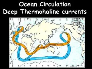
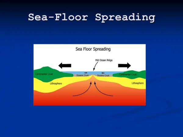
Horizontal water movement: 2. Deep Circulation.
Basic ideas: WARM or LESS SALTY WATER RISES UP ! DOWN ! COLD or MORE SALTY WATER SINKS
THE SURFACE AND DEEP WATERS OF ALL MAJOR OCEANS ARE CONNECTED TOGETHER.
o o Deep ocean circulation (Stommel, 1958; Deep-Sea Res., 5, 80-82). Dots (o) are locations of deep water formation.
Vertical water movement: Upwelling.
2 things may cause upwelling: 1. WATER MASSES MOVING APART. 2. WATER MOVING AWAY FROM LAND.
DUE TO CORIOLIS, EQUATORIAL CURRENTS TEND TO DIVERGE OR MOVE APART CAUSING UPWELLING IN THE OPEN OCEAN.
CAUSES WATER TO MOVE AWAY FROM LAND IN EACH HEMISPHERE
In the southern hemisphere, wind and surface currents move from south to north causing coastal upwelling.
California In the northern hemisphere, wind and surface currents move from north to south causing coastal upwelling.
SUNLIGHT PHOTIC ZONE THE BIOLOGICAL IMPORTANCE OF UPWELLING IN THE SEA.
SUNLIGHT PHOTIC ZONE FERTILIZING NUTRIENTS FOR PHOTOSYNTHESIS ARE LOST TO THE BOTTOM, BELOW THE PHOTIC ZONE
SUNLIGHT PHOTIC ZONE ONLY UPWELLING CAN RETURN THE FERTILIZING NUTRIENTS TO THE PHOTIC ZONE
COASTAL UPWELLING ALONG THE WEST COAST. NOTICE THE COLDER WATER NEAR THE LAND, COMPARED TO THE WARMER WATER OFFSHORE.
COASTAL UPWELLING ALONG THE WEST COAST. THE LIGHT COLORS REPRESENT COLD TONGUES OF WATER MOVING OFFSHORE DUE TO UPWELLING ALONG THE COAST.
Horizontal water movement: 3. Currents along the shoreline.


![How I Turned $25 Into A Dot-Com-Lifestyle And How You Can Do The Same [Shh… Secrets Inside!]](https://cdn4.slideserve.com/7516319/slide1-dt.jpg)