Download
1 / 1
10 likes | 106 Views
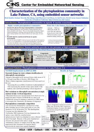
Utilizing aerial imagery and historical data to identify abandoned travel networks as secondary evacuation routes in Lake California. Incorporating remote sensing tools for landscape characterization and disaster management. Data acquisition and analysis procedures outlined. Sources of error discussed to ensure accuracy in identifying potential emergency roadways. Results and conclusions of the study detailed.

E N D
Methodology Sources of Error Discussion and Conclusion Aerial View of the Lake California Housing Development References MAPPING THE ABADONED TRAVEL NETWORKS OF THE COMMUNITY OF LAKE CALIFORNIA IN ORDER TO ESTABLISH A SECONDARY EVACUATION ROUTE Jessica Riske-Gomez Department of Geosciences, Oregon State University GEO 544 – Fall 2012 Introduction In the case of a catastrophic wildfire, or equivalent environmental emergencies, it has been determined that the movement and activities of the public should be controlled if and when it becomes necessary to establish safe routes in order to move the population. Evacuation directives are designed to remove all occupants from a specific area by a pre-determined route. Three main elements should be considered in the preparation of a traffic control plan for an evacuation: 1) Evacuation Routes, 2) Perimeter control, and 3) Traffic Coordination. This document primarily concerns itself with element 1, Evacuation Routes. Selection of routes should take into account the volume of evacuee traffic, the available selection of suitable roadways, and the volume of responder traffic in the area. Alternate routes should be considered when at all possible. The use of abandoned country roads, two-tracks, utility easements and trails systems may also be considered. Unfortunately local knowledge of these trails may have been lost from lack of common use. It is the assertion of this project that by using the tools of remote sensing, combined with historical maps and documents, that these abandoned systems can be identified, mapped and reclaimed for use in an emergency situation. Remotely sensed aerial and satellite imagery are valuable tools for the characterization of the landscape. They provide valuable data for mapping, environmental monitoring and disaster management (Benz et al 2004). Additionally, remotely sensed aerial imagery is a valuable tool for the characterization of the archaeological landscape and historical travel routes (Kucukkaya A. 2004). This project is intended to use a combination of digital high resolution color aerial imagery, satellite imagery, historical documents and historical aerial photography of Lake California to explore the potential of remote sensing and image processing methods for operational mapping of trail networks (Kaiser et al 2004). This project utilizes data archival imagery collected by various Federal agencies in order to identify the lost or discreetly used trail systems surrounding Lake California. Hypothesis: It is the assertion of this project that aerial imagery, historical maps, and local knowledge can be used to identify abandoned or unmapped travel networks. In order to determine their suitability for emergency evacuations potential roadways will be identified on current aerial images. These potential roadways will be cross-referenced with historical maps and aerial images from 1963 and 1976 to determine if they were in common use at one time. Potential routes will be subject to field verification. After verification the most suitable route will be identified and recorded. Data, Acquisition and Analysis: A Quickbird satellite image was acquired from TerraServe. The image was taken on 6/12/2010 at a resolution of 30cm, covering an areas of 6.89 sq.km., UTM Zone 10, WGS.84. Additionally, for reference, archived aerial images were acquired from the USGS taken in 05/04/1963 which pre-dates the development and 07/09/1976. Historic maps from the area were gathered, specifically, the Official Map of the State of California, Tehama County, 1854. The Quickbird image was imported into ArcGIS. All subsequent derived datasets were defined as UTM Zone 10, WGS 84. Visual inspection and interpretation was used to identify areas of motor vehicle activity and guide further exploration. Sections of existing road were identified in the southern region of the Lake California development. This region was isolated as an area with a high density of existing two-tracks. The most useful road segments were identified and converted to a shapefile. A second shapefile was then created joining the sections of visible road creating a single continuous path. Several sources of error could have affected the analysis. Error may have been introduced at any step throughout the process, including feature confusion based on the similar reflectance values of trails and dry creek beds, data import and processing techniques used in this study, and human error during visual data analysis. Results Background This study was designed as a general investigation into the Lake California development to identify a secondary evacuation route. The project utilized visual examination of aerial imagery taken between 1963 and 2010. These images allowed for a quick and effective estimation of two-tracks that exist in the area. Methods of data processing and analysis developed for this project primarily involved raster-based visual analysis and interpretation using ArcGIS. Visual interpretation was verified in the field as is reflected in the on ground images. There was little evidence to support the claim that there may be historical routes through the project study area. There are literary references to an Old River Road that may have skirted the east boundary of the study area. Unfortunately, there were no available maps that identified that specific route. Also, it would most likely be under the location of the water waste treatment facility making that potential route useless. At the completion of this analysis two options were created. These two paths connect the above service road identified by Google Earth as River View Drive to Nunes Road. Nunes is a paved private road the joins with Jelly’s Ferry Road. The southern boundary was the focus of the study due to the availability of the Jelly’s Ferry Road which connects with I-5 to the west and crosses the Sacramento River to the east. It is the assertion of this project that remote sensing can be utilized to identify is secondary routes from the Lake California development. This project show that there are available trails and two-tracks that may be utilized for emergency evacuations. Theses dirt roads are in common use by ranchers, utility power line workers, recreationalists, cattle and game. While it is unsupported that these two tracks have any historical value they are available for use. • Lake California is a private gated community located near the town of Cottonwood, CA (40.35° N latitude, 122.20° W longitude). Historically this area was developed for exclusive use as a resort community, geographically this community is extremely contained. The design of the development was implemented specifically to funnel all traffic through the guarded main gate. The north boundary of the development is defined by the Cottonwood Creek. The northeast corner of the development is anchored by the confluence of the Cottonwood Creek and the Sacramento River. The Eastern boundary of the development is defined by the Sacramento River. Lake California lacks a river crossing. The river flanks the community and connects with a steep ridgeline that defines the southern side of the development. There is a single road from Lake California connecting it to the Sacramento Valley and the I-5 corridor. The road runs between two private ranches that do not allow public access. Unfortunately, the community never took off as a destination location. With the decreasing demand for second homes the ¼ acre lots were bought by local construction companies and developed as speculation homes. With the recent real-estate boom the community has experienced a huge increase in development creating the concern that the narrow two lane County road is unsafe for the amount of traffic that it is currently experiencing. Additionally, if there were to be any sort of environmental emergency from the west side of the development, the residents of Lake California could essentially be stranded. There are, however, unused fire lines, two-track dirt roads, historical river bi-ways, and high-tension power lines that spider-web the area. Isolated Southern Boundary of the Development Aerial Imagery of the project area, 1974. Historical Context Quickbird Satellite Imagery With Two Suggested Routes Official map of the state of California, Tehama County, 1854. U.S. Geological Survey. Bend Quadrangle, California-Tehama Co. 1:24,000. 7.5 Minute Series. United States Department of the Interior, USGS, 2012. Benz, H., Willhauck, G., Lingenfelder, I., and M. Heynen 2004; Multi-resolution, object-oriented fuzzy analysis of remote sensing data for GIS-ready information. ISPRS Journal of Photogrammery and Remote Sensing. V. 58, I. 3-4, January 2004, pp. 239-258. Kaiser, J., Douglas, A, and Lina Cao, 2004; Evaluation of Remote Sensing Techniques for Mapping Transborder Trails. American Society for Photogrammetry and Remote Sensing, V. 70 N. 12, pp. 1441-1447 Kucukkaya A. 2004: Photogrammetry and remote sensing in archeology. Journal of Quantitative Spectroscopy and Radiative Transfer. V. 88, I. 1-3, 15 September 2004-October 2004, pp 83-88. Mohamed, R. and Ahmad Al-Gilani; Documenting Kara Caravan Trail Using Mult-Temporal Remote Sensing and GIS Techniques. King Abdulaziz University, Department of Landscape Architecture, Jeddah, Saudi Arabia. U.S. Geological Survey. Bend Quadrangle, California-Tehama Co. 1:24,000. 7.5 Minute Series. United States Department of the Interior, USGS, 2012. Official map of the state of California, Tehama County. Approved by an act of the legislature passed March 25,1853. Comp. by W. R. Eddy, state surveyor general. Publ. for R. A. Eddy, Marysville, Cal., by J. H. Colton, N.Y. 1854. Clockwise from top left, Image from missing line segments of the feature, image from segments of feature that were assumed to be part of road but needed field verification, image of line feature that were clearly visible from satellite image that were verified to be a two-track road. Project area as shown reflects no major travel activity through the southern boundary. This can be attributed to alternative routes to the east and west around the steep ridge. Aerial Imagery of the project area, 1963.