Download
1 / 19
190 likes | 345 Views
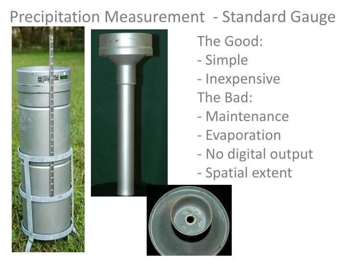
Precipitation Measurement - Standard Gauge. The Good: Simple Inexpensive The Bad: Maintenance Evaporation - No digital output - Spatial extent. Precipitation Measurement - Weighing Gauge. The Good: Time series Simple (mostly) The Bad: Messy maintenance Moving parts

E N D
Precipitation Measurement - Standard Gauge • The Good: • Simple • Inexpensive • The Bad: • Maintenance • Evaporation • - No digital output • - Spatial extent
Precipitation Measurement - Weighing Gauge • The Good: • Time series • Simple (mostly) • The Bad: • Messy maintenance • Moving parts • - No digital output • Spatial extent • Pretty expensive
Precipitation Measurement - Tipping Bucket • The Good: • Digital time series • Accurate • The Bad: • Snow? • - Loss during tips Data Logger
Precipitation Measurement - Piezoelectric • The Good: • Very accurate • Digital data logger • The Bad: • Expensive • - Spatial extent
Acoustic Rain Gage • The Good: • Very accurate • Spatially explicit • Digital data logger • The Bad: • Expensive
Doppler Radar A standard rain gage will have a sample area of ~ ft2, but radar will sample ~ hundreds mi2
Stick gage - $400 Tipping bucket - $1,000 Weighing - $5,000+ Doppler - $5,000,000
Measurement Errors • Placement (near structures) • Wind • Unequal distribution (rain is a spatial process) Placement:
Wind Error 1. Reduced effective catch area. 2. Rain gage will cause wind to lift and accelerate.
Dealing with Spatial Variability Arithmetic Mean ThiessenPolygon Interpolation
Icacos , Puerto Rico 423 mm/yr Pico del Este, Puerto Rico 340 mm/yr Monteverde, Costa Rica 350 mm/yr Cloud Drip Some tropical watershed research shows that cutting cloud forests actually reduces stream flow.
Hail and sleet are frozen rain, where as snow crystals form when water vapor condenses directly into ice. As much as 75 percent of water supplies in the western United States are derived from snowmelt . 300 inches of snow that the Lake Tahoe area receives is equivalent to about 30 inches of rain.
Snow Measurement Snow pack Core sampling Snow “Pillow”
Getting Rain Data • http://fawn.ifas.ufl.edu • SJRWMD • National Climate Data Center • National Weather Service (NOAA)