Download
1 / 4
40 likes | 180 Views
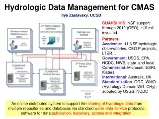
Hydrologic Data Management for CMAS. Ilya Zaslavsky, UCSD. CUAHSI HIS : NSF support through 2012 (GEO), ~10 mil invested Partners: Academic : 11 NSF hydrologic observatories, CEO:P projects, LTER… Government : USGS, EPA, NCDC, NWS, state and local Commercial : Microsoft, ESRI, Kisters

E N D
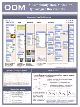
Hydrologic Data Management for CMAS Ilya Zaslavsky, UCSD CUAHSI HIS: NSF support through 2012 (GEO), ~10 mil invested Partners: Academic: 11 NSF hydrologic observatories, CEO:P projects, LTER… Government: USGS, EPA, NCDC, NWS, state and local Commercial: Microsoft, ESRI, Kisters International: Australia, UK Standardization: OGC, WMO (Hydrology Domain WG, CHy); adopted by USGS, NCDC An online distributed system to support the sharing of hydrologic data from multiple repositories and databases via standard water data service protocols; software for data publication, discovery, access and integration.
Consortium of Universities for the Advancement of Hydrologic Science, Inc. 122 US Universities as of July 2008 An organization representing more than one hundred United States universities, receives support from the National Science Foundation to develop infrastructure and services for the advancement of hydrologic science and education in the U.S. http://www.cuahsi.org/
Integration of Disparate Data Deployment All accessible through standard WaterML interface. Currently over 1.75 mil stations, servers in US and Australia. Free software
HIS in CMAS • Premise: • Having a consistent data infrastructure for modeling across city will make it easier to calibrate and customize models, compare results, will support a variety of other analysis, visualization and modeling efforts, reduce duplication in data collection, support partnerships • Plans: • Capacity building workshops (first hands-on workshop is planned in Malaysia in July, have seed funding) • Setting up HIS Servers to help publish local hydrologic data + training • Create an online forum for hydrologic modeling in tropical areas • Analyze hydrologic data availability for study cities; calibrate available remote sensing data for use as Geo-HMS inputs • Adjust data protocols, validate standards and ontologies based on local context • To date: • Project web portal partly built (participants can edit content, upload data, use wiki, etc.). Currently has documents, links to data and modeling resources, news feeds, etc. • TRMM investigated as possible source of precipitation data (http://river.sdsc.edu/wiki/TRMM%20notes.ashx.)