Download

1 / 8
80 likes | 178 Views
Study explores rainfall isotopes and climate patterns in Luquillo Mountains, Puerto Rico, to understand streamflow maintenance. Data collected from nine sites analyzed monthly. Advanced weather analysis and isotopic composition studies provide valuable insights.

E N D
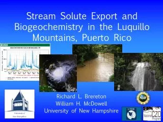
Links between rainfall stable isotopes and climate patterns in the Luquillo Mountains, Puerto Rico Martha Scholl, U.S. Geological Survey African dust kickoff meeting, UPR January 2010
Objectives and Methods • Establish the isotopic signatures of rain from different climate patterns • Nine sites, monthly samples of rain and cloud water for analysis of d18O and d2H • Detailed climate analysis from weather data, NWS summaries and NEXRAD echo tops • Determine which climate patterns are important in maintaining streamflow • Samples from top to bottom of two watersheds during rainy and dry seasons • Monthly samples at one site on each stream
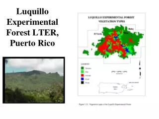
Precipitation collector sites across the Luquillo Mountains, 2005-present 3 years of data at all 9 sites, network was reduced to 4 rain collectors in 2008: Mameyes, Bisley, Pico del Este, Icacos
Weather Analysis for Isotope Study, E. Puerto Rico • Rain gage record with 5 to 15-minute measurement interval, Icacos station. • 2. Parse record into rain events (3-hour separation). • 3. Sort rain events by size within isotope sampling period. • 4. Assign a weather type to each event from NWS summaries until 80+ % of rain is accounted for. • 5. Determine mean echo top altitudes for the largest events until >50% of the rain is accounted for. • 6. HYSPLIT back-trajectories for a subset of events.
NEXRAD Echo tops • Represent the top of the rain-producing layer in a cloud. • Available every 10 minutes during a rain event. • Pixels are 4 x 4 km (x,y) and 1524 m (z) resolution. • Ranged from 760 – 16,000 m in Puerto Rico.
Seasonal patterns in weather systems, rain water stable isotopes, and cloud height correspond. Scholl et al., 2009, Water Resources Research, doi:10.1029/2008WR007515
Plans/ ideas • Continue to analyze echo-top altitude and weather type for events in Luquillo Mountains. • Contribute to long-term cloud base measurements and data analysis. • Visibility measurements - cloud immersion frequency and diurnal timing. • Isotopic analyses of cloud water collected with CASCCs, also water vapor when possible. • Compare water stable isotope composition of rain from dust-affected and other events. Automated high-resolution temporal sampling.