Download
1 / 21
210 likes | 348 Views
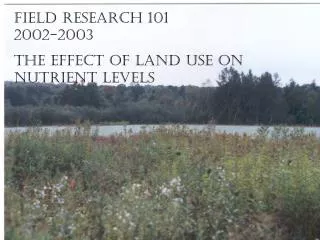
Field Research 101 2002-2003 The effect of Land use on nutrient levels. Purpose: to determine the effect of watershed land use on phosphate and nitrate levels in streams.

E N D
Field Research 1012002-2003 The effect of Land use on nutrient levels
Purpose: to determine the effect of watershed land use on phosphate and nitrate levels in streams
Setup: I chose to monitor the nutrient levels of two different sites along Beaver Creek, one upriver and one downriver. By comparing the nutrient levels and determining the difference in land use between the two sites, I would be able to find the effect land use had on the nutrient levels.
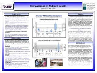
Nutrient Levels • I took samples from two sites, one upstream (Farm site) and one downstream closer to Beaver Creek Reserve (Beaver Creek site).
Then, using a Hoch 2010 Spectrophotomer and some AccuVac Ampuls, I analyzed the water samples for their Phosphate and Nitrate levels.
I used Microsoft Excel to keep track of the data. When all the data had been collected, I used some data analysis tools found in Excel to do a T-Test on my data to see if the two sites were significantly different.
The T-Test reported that the Phosphate levels at the two sites were not significantly different. However, it did find that the nitrate levels were different.
Determining Difference in Land Use To determine the difference in land use between the two sites, I took the following steps:
Using watershed and elevation data from the DNR, I broke the Lower Eau Claire Watershed into sub-watersheds and sub-sub-watersheds, with boundaries dependant on sampling sites
Next, I used ArcView to overlay a picture of different land use types onto my newly created watersheds
Then, I roughly digitized the land uses by hand using the land use data from the DNR as an outline to find the land use of the smaller watershed
I repeated the process on the bigger watershed, and used ArcView to calculate the total areas of each of the land use types
Once the areas were in Excel, I created a few graphs to show the difference in land use. Unfortunately, I wasn’t able to discern a real big difference in the land use between the two sites
Conclusions • Because there wasn’t a big enough difference in the land uses (as well as some of the nutrient levels themselves, my data does little to explain my purpose: to find out the effect land use has on nutrient levels • This shows that the Lower Eau Claire Watershed (or at least the part I studied) is fairly well protected- there aren’t inconsistencies