Download
1 / 47
470 likes | 489 Views
This presentation explores the application of short range ensemble forecasts (SREF) to convective aviation forecasting, including the use of ensemble guidance at the Storm Prediction Center (SPC) and post-processed guidance. It also discusses the sources of forecast errors and the concept of predictability in weather forecasting.

E N D
Application of Short Range Ensemble Forecasts to Convective Aviation Forecasting David Bright NOAA/NWS/Storm Prediction Center Norman, OK Southwest Aviation Weather Safety Workshop October 23-24, 2008 Where Americas Climate and Weather Services Begin
Outline • Introduction • Short Range Ensemble Forecasts (SREF) • Future Aviation Ensemble Applications
Outline • Introduction • The SPC, predictability, and ensembles • Short Range Ensemble Forecasts (SREF) • Future Aviation Ensemble Applications
STORM PREDICTION CENTER LOCALIZED HIGH IMPACT WEATHER • Hail, Wind, Tornadoes • Fire Weather • Winter Weather • Excessive Rainfall
The Butterfly Effect • Ensemble forecasting can be formally traced to the discovery of the "Butterfly Effect" (Lorenz 1963, 1965)… • The atmosphere is a non-linear, non-periodic, dynamical system such that tiny errors grow ... resulting in forecast uncertainty that increases with time resulting in limited predictability • “Does the flap of a butterfly’s wings in Brazil set off a tornado in Texas?” (Lorenz 1972) • Or, does the formation of an isolated storm over the Mogollon Rim set off a flash flood near Phoenix? • Predictability is a function of temporal and spatial scales: e.g., thunderstorms are inherently less predictable than synoptic scale cyclones
What are the Sources of These Tiny Errors? Observations, Assimilation, and Models • Observations • Data gaps • Error • Representative • QC • Analysis • Models • LBCs, etc. Satellite Aircraft and Land
Reality One model forecast
Numerical weather models... • All forecasts contain errors that increase with time • Doubling time of small initial errors ~1 to 2 days • Maximum large-scale (synoptic to planetary) predictability ~10 to 14 days • Ensembles… • A collection of models that provide information on the range of plausible forecasts, statistical measures of confidence, and extend predictability • Scales to the problem of interest • Increasing in popularity • Requires “tools” to view the large number of models using a slightly different approach (statistical) Weather forecasting: It’s impossible to be perfectly correct all of the time!
Outline • Introduction • Short Range Ensemble Forecasts (SREF) • Currently available through the SPC website • Future Aviation Ensemble Applications
Ensemble Guidance at the SPC • Develop specialized guidance for the specific application (convection, severe storms, fire weather, winter weather) • Design guidance that… • Help blend deterministic and ensemble approaches • Provide guidance for uncertainty/probabilistic forecasts • Provide guidance that aids confidence (i.e., better deterministic forecasts) • Illustrates plausible scenarios • Allows for diagnostic analysis – not just a statistical black-box
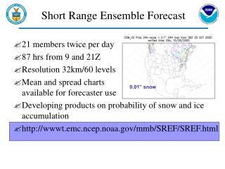
Ensembles Available at the SPC: SREF NWS/NCEP Short Range Ensemble Forecast (SREF) • EMC SREF system (21 members) • 87 hr forecasts four times daily (03, 09, 15, 21 UTC) • North American domain • Model grid lengths 32-45 km • Multi-model: Eta, RSM, WRF-NMM, WRF-ARW • Multi-analysis: NAM, GFS initial and boundary conds. • IC perturbations and physics diversity • Recently added bias-correction to some fields (not covered and not available on the SPC webpage)
All example products available on the SPC webpage http://www.spc.noaa.gov/exper/sref/ http://w1.spc.woc.noaa.gov/exper/sref/frames.php?run=case_2007060803
Basic Overview [MN]: = Mean [SP]: = Spaghetti [MNSD]: = Mean/SD [MAX]: Max value at each grid point
Instability [MN]: = Mean [PR]: Probability [MDXN]: Median/union & intersect [SP]: = Spaghetti [MNSD]: = Mean/SD
Winds and Vertical Shear [MN]: = Mean [SP]: = Spaghetti [MNSD]: = Mean/SD [MDXN]: Median/union & intersect [MAX]: Max value at each grid point
SREF Pr[ESHR > 30 kts] & Mean ESHR=30 kts (dash) “Effective Shear” (ESHR; Thompson et al. 2007, WAF) is the bulk shear in the lower half of the convective cloud
Precipitation [MN]: = Mean [SP]: = Spaghetti [MNSD]: = Mean/SD [MDXN]: Median/union & intersect [MAX]: Max value at each grid point
SREF Pr[C03I > .01”] and Mean C03I = .01” (dash) C03I = 3hr Convective Precipitation
Severe Weather [MN]: = Mean [SP]: = Spaghetti [MNSD]: = Mean/SD [MDXN]: Median/union & intersect [MAX]: Max value at each grid point
SREF Combined or Joint Probability Probability of convection in moderate CAPE, moderate shear environment Pr [MUCAPE > 1000 J/kg] X Pr [ESHR > 30 kts] X Pr [C03I > 0.01”]
Post-Processed Guidance [PR]: = Probability (Calibrated)
SREF 3h Calibrated Probability of a Thunderstorm Thunderstorm = > 1 CG Lightning Strike in 40 km grid box (Bright et al., 2005) http://ams.confex.com/ams/pdfpapers/84173.pdf
Calibrated SREF Thunder Reliability Frequency [0%, 5%, …] Perfect Forecast No Skill Climatology Calibrated Thunder Probability
SREF 3h Calibrated Probability of a Severe Thunderstorm Severe Thunderstorm = > 1 CG Lightning Strike in 40 km grid box and Wind > 50 kts or Hail > 0.75” or Tornado (Bright and Wandishin, 2006) http://ams.confex.com/ams/pdfpapers/98458.pdf
Severe Verification Hail > .75” Wind > 50 kts Tornado 21 UTC F039 24h forecasts from 15 April to 15 October 2005 ROC Area= .86 Ave Hit = 15% Ave Miss= 3% (24h Fcst: F39, 21Z only) 21 UTC SREF only
Aviation Guidance [MN]: = Mean [MD]: Median/union & intersect [MAX]: Max value at each grid point [CPR]: Conditional probability [PR]: Probability
Test Version: 03Z SREF Day 1 ENH Guidance (Summer 2008) Probability Echo Tops >= 35KFT
Severe Weather on June 9, 2007 • 107 total severe reports in CONUS • 3 tornadoes over nrn New Mexico (~22 UTC)
Outline • Introduction • Short Range Ensemble Forecasts (SREF) • Future Aviation Ensemble Applications • Applications and calibration under development • One hourly SREF thunderstorm guidance (through F036) * • Calibration of potential impacts of convection in SREF ^ • Rapid Refresh Ensemble Forecast (RREF) – 1hr updates, RUC based * • Storm scale (e.g., supercells, squall lines) applications being evaluated *Not discussed today ^Collaborating with John Huhn, Mitre Corp.
Gridded Flight Composite (20 km)December 2007 to August 2008 – Above 250 KFT Probability (%) aircraft is inside grid box 20 km Grid (AWIPS 215) Data from John Huhn, Mitre
Gridded Flight Composite (40 km)December 2007 to August 2008 21 UTC Composite < 10 KFT 21 UTC Composite > 25 KFT Probability (%) aircraft is inside grid box at exactly 21 UTC
Example of Potential ImpactsProbability Thunderstorm X Gridded Composites SREF F036: 3h Calibrated Probability of a T-storm Valid: 21 UTC 8 June 2007 SREF F036: Impact Potential Below 10 KFT Valid: 21 UTC 8 June 2007 SREF F036: Impact Potential Above 25 KFT Valid: 21 UTC 8 June 2007
Future Applications: Storm Scale Ensemble (SSEF) • NOAA Hazardous Weather Testbed (HWT) • HWT Spring Experiment • Focused on experimental high-res WRF forecasts since 2004 (dx ~2-4 km) • Convection allowing ensemble forecasts (2007-2009) to address uncertainty • 10 WRF members • 4 km grid length over 3/4 CONUS • Major contributions from: SPC, NSSL, OU/CAPS, EMC, NCAR • Resolving convection explicitly in the model • Evaluate the ability of convection allowing ensembles to predict: • Convective mode (i.e., type of severe wx) • Magnitude of severe type (e.g., peak wind) • Aviation impacts (e.g., convective lines/tops) • QPF/Excessive precipitation • Year 1 Objective (2007): Assess the role of physics vs. initial condition uncertainty at high resolution 2003 Spring Experiment
Probability Updraft Helicity > 50 m2/s2 Probability of Supercell Thunderstorms F026: Valid 02 UTC 22 Apr 2008 UH > 50 + 25 mi
Observed Radar Radar BREF 0142 UTC 22 Apr 2008
Probability Updraft Helicity > 50 m2/s2 Jack Hales View of the left split looking south from Norman, OK (0145 UTC 22 Apr 2008) (Numerous large hail reports up to 2.25”)
Convective Mode: Linear Detection • Determine contiguous areas exceeding 35 dbZ • Estimate mean length-to-width ratio of the contiguous area; search for ratios > 5:1 • Flag grid point if the length exceeds: • 200 miles
Probability Linear Mode Exceeding 200 miles Squall Line Detection F024: Valid 00 UTC 18 Apr 2008 Linear mode + 25 miles
Probability Linear Mode Exceeding 200 miles Squall Line Detection F026: Valid 02 UTC 18 Apr 2008 Linear mode + 25 miles
Probability Linear Mode Exceeding 200 miles Squall Line Detection F028: Valid 04 UTC 18 Apr 2008 Linear mode + 25 miles
Linear Convective Mode: Impacts Aviation impacts ~ 01 UTC 18 April 2008 Image provided by Jon Racy
Summary: Ensemble Applications in Convective/Aviation Forecasting • Ensemble approach to forecasting has many similarities to the deterministic approach • Ingredients based inputs • Diagnostic and parameter evaluation • Ensembles contribute appropriate levels of confidence to the forecast process • Ability to view diagnostics and impacts in probability space • Calibration of ensemble output can remove systematic biases and improve the spread • Ensemble techniques scale to the problem of interest (weeks, days, or hours) • Ensemble systems are here to stay…and will evolve downscale toward high-impact forecasting
SPC SREF Products on WEB http://www.spc.noaa.gov/exper/sref/ Questions/Comments… david.bright@noaa.gov