Download
1 / 1
10 likes | 103 Views
Investigating bias in GPS data due to unmodelled vertical signals, with sensitivity to parameter estimation highlighted. Results and conclusions from sub-daily and daily batches analyzed.

E N D
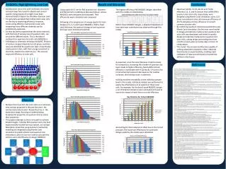
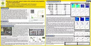
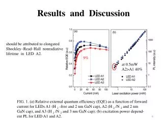
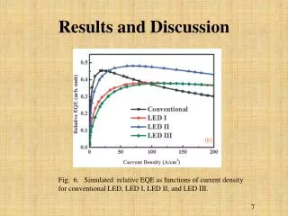
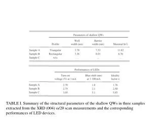
G52A-0972 AGU Fall 2002 Meeting Parameter Bias When Processing GPS Data Containing Unmodelled Vertical Signals: Sensitivity Analysis Matt KingSchool of Civil Engineering and Geosciences, University of Newcastle upon Tyne, UK • email m.a.king@ncl.ac.uk Richard ColemanSchool of Geography and Environmental Studies, University of Tasmania, Australia • email Richard.Coleman@utas.edu.au Introduction The influence of unmodelled vertical signals on GPS batch least squares parameter estimates (coordinate, ambiguity or TZD parameters) is often ignored despite the consequences not always being well understood. Studies where the signal period does not match the batch lengths are of particular interest in this regard. For example, ocean loading studies typically use batch lengths of 1-2 hrs during which time the ocean loading signal is unmodelled. Deformation due to atmospheric loading is also typically ignored in a range of GPS solutions. We have tested parameter sensitivity to such unmodelled vertical signals by way of a sensitivity analysis1. Results and Discussion Test 1: Sub-daily batches The above figure shows the results for sites at latitudes 0°, 45° and 90°. At 0° and 45°, biases (Δ) are present in the east coordinate components when ambiguities are not fixed to integer values, whereas they are not present in the ambiguity fixed solutions. Biases are also present in the north component, but with a lower magnitude. The magnitude of these biases is predominantly a function of the gradient of the unmodelled vertical signal. The ambiguity parameters absorb the unmodelled vertical motion and when the ambiguity adjustments are mapped into their horizontal coordinate components (NHoriz) it is evident that the horizontal coordinates and ambiguity parameters ‘balance’ one another in the least squares estimation process. The latitudinal dependence of the bias in the east component is shown in the above figure. Since the bias is related to the ambiguity parameters, the magnitude and direction of the bias is directly related to the local satellite constellation. At all latitudes the height component and TZD parameters are not affected by the presence of the unmodelled vertical signal. These sensitivity analyses have been verified using data collected on a floating ice shelf. Test 2: Daily batches In the case of 24 hr batches, the coordinate biases mirror those of the sub-daily batches. However, since the mean gradients of the atmospheric / ocean loads are small or zero, the coordinate biases are sub-mm and hence are not significant. The figures below show that the TZD estimates are also biased and related to the unmodelled vertical signal. The ratio of vertical signal to TZD bias varies depending on the gradient of the vertical signal (left hand figure) as well as the station latitude (right hand figure) and elevation cut-off angle. These may explain the differences from previous studies1,4,5. The chosen mapping function will also affect the ratio. • Sensitivity Analysis • Matlab™ implementation based on the single difference observable2,3 • Station coordinates (n, e, u) and TZD parameters estimated at any frequency. Ambiguity parameters (N) estimated at each new satellite pass and at new coordinate batches. Clock synchronisation parameters (δtr) estimated every epoch. Other error sources are assumed to be negligible or modelled • Time-dependent biases are allowed • Satellites positions are provided via broadcast satellite orbits1. Station coordinates are user selectable • Ambiguity fixing (when performed) is simulated by excluding ambiguity parameters from the adjustment • Two tests were performed: • Test 1: Hourly coordinate batch solutions (ocean loading estimation scenario) of data containing an unmodelled diurnal vertical signal with an amplitude of 100 mm • Test 2: Daily coordinate batch solutions (atmospheric or ocean loading scenarios) with an unmodelled vertical signal. Atmospheric loading: 2 week period, amplitude 10 mm; Ocean loading: 1 day period, amplitude 100 mm • “zero-baseline” solutions • 10° satellite elevation angle cut-off • TZD parameters estimated hourly • Simple sec(zenith angle) mapping function adopted • Ambiguity fixed and free solutions computed • Conclusions • To estimate accurate sub-daily horizontal coordinates all vertical signals must be accurately modelled or ambiguities must be resolved. Our tests show that only 40-50% of ambiguities need resolving to reduce the biases to below the 1 mm level. The accuracy of vertical coordinates and tropospheric zenith delay estimates, on the other hand, are unaffected by the presence of unmodelled vertical signals in these sub-daily solutions. • TZD estimates are biased by unmodelled vertical signals when coordinates are estimated daily. Biases induced by atmospheric loading are not significant in terms of IPWV. The ratio of the vertical signal to TZD bias varies as a function of unmodelled signal gradient, site latitude and satellite elevation cut-off and is in the range ~4.0-6.5. References 1.Santerre, R., Impact of GPS satellite sky distribution, Manuscr. Geodaet., 16, 28-53, 1991. 2. We thank Kai Borre and Gilbert Strang for making their Matlab™ routines freely available. 3. For further information on this work see: King, M., R. Coleman, and L.N. Nguyen, Spurious periodic horizontal signals in sub-daily GPS position estimates, Journal of Geodesy, in press. 4. Dach, R., and R. Dietrich, Influence of the ocean loading effect on GPS derived precipitable water vapor, Geophys. Res. Lett., 27 (18), 2953-2956, 2000. Vey, S., E. Calais, M. Llubes, N. Florsch, G. Woppelmann, J. Hinderer, M. Amalvict, M.F. Lalancette, B. Simon, F. Duquenne, and J.S. Haase, GPS measurements of ocean loading and its impact on zenith tropospheric delay estimates: a case study in Brittany, France, J. Geodesy, 76 (8), 419-427, 2002.