Download

1 / 24
240 likes | 506 Views
Geographic Information Systems (GIS). An Introduction. Geographic Information Systems. Information Systems : Systems designed to manipulate and analyse data in order to generate new derivative information GIS : Information systems that work with geographic or spatial data.

E N D
Geographic Information Systems (GIS) An Introduction
Geographic Information Systems • Information Systems: Systems designed to manipulate and analyse data in order to generate new derivative information • GIS: Information systems that work with geographic or spatial data
What is GIS About? • Is it mapping? • GIS is about using data to describe & analyse our world in two ways: • Location Data - Where is it? • Attribute Data - What is it?
GIS: Links Data Sets GIS software links the location data and the attribute data:
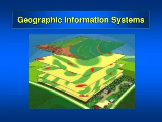
Geography • Census Data • Transportation GIS: Layers GIS can contain many layers of information: These are just a few of the kinds of layers a GIS can contain:
GIS: Analysis GIS can analyse data in many ways:
Attribute Questions: What provinces have more than 1.5 million people? Spatial Questions: What provinces border Saskatchewan? Queries
Other Analytical Techniques • Proximity • Buffers • Neighbourhoods • Overlays • Network analysis • Cost Distances
GIS & Technology • Geography has become a hi-tech discipline • Geographic Information Systems (GIS) • Earth Observation (Remote Sensing) • Global Positioning Systems (GPS)
Global Positioning Systems • GPS is a positioning system • 24 satellites orbiting the earth • Provide location within cm.’s anywhere on the globe.
Who’s Using GIS? • Real Estate • Marketing • Economic Development • Internet • Insurance • Appraisal & Assessment • Environmental • Park Management • Agriculture • Public Utilities • Health Care • Emergency 911 • And …..
Environmental • What are the effects of global warming? Land cover & temperature relationships are made clear when the data are seen at once using GIS, or can be statistically analysed.
Floodplain Delineation What addresses within an urban area may be prone to flooding, & how much are the potential damages?
Park Management • Will the new building spoil the park scenery? Park planners use GIS to determine whether a new Visitor Centre can be seen from the peak.
Agriculture • How can food production be improved? GIS is used in making crop management decisions to maximize yields & minimize fertilizer input.
Public Utilities • Identify facilities & connecting networks A proposed excavation, identified by address, is compared to pipelines in the area using GIS.
Health Care • What communities are at risk from disease? GIS identifies communities at risk of water borne diseases & helps determine the effectiveness of the treatment plans.
Emergency 911 • What is the fastest route to the hospital? GIS can choose the fastest route to a hospital, including traffic & other impediments.
Real Estate • Where is the best location? With GIS, suitable locations can be identified, a map of a neighbourhood produced, as well as pictures or videos of the actual properties.
Marketing • Optimise marketing campaigns GIS can query a database & identify only those areas with the highest household income within a specified distance of a store.
Economic Development • Data from the municipal government can be made more accessible GIS can provide data on available properties, traffic counts, re-development project areas, & demographics over the net.
New Business Applications are developed each monthGIS an example of a Technology meeting evolving Business needs