Download
1 / 53
540 likes | 706 Views
Meso- and Storm-scale Probabilistic Forecasts from the RUC, Rapid Refresh, and High-Res Rapid Refresh (HRRR). Stan Benjamin and Steve Weygandt NOAA Earth System Research Lab, Boulder, CO Curtis Alexander, John Brown, Doug Koch Geoff DiMego - NCEP. 23 Sep 2009. http://ruc.noaa.gov/hrrr

E N D
Meso- and Storm-scale Probabilistic Forecasts from the RUC, Rapid Refresh, and High-Res Rapid Refresh (HRRR) Stan Benjamin and Steve Weygandt NOAA Earth System Research Lab, Boulder, CO Curtis Alexander, John Brown, Doug Koch Geoff DiMego - NCEP 23 Sep 2009 http://ruc.noaa.gov/hrrr http://rapidrefresh.noaa.gov
Meso- and Storm-scale Probabilistic Forecasts from the RUC, Rapid Refresh, and HRRR • Outline: • Need for hourly updated probabilistic forecasts from the RUC (and upcoming Rapid Refresh and HRRR) • Experiences with Time-lagged ensembles • RUC Convective Probabilistic Forecast (RCPF) • HRRR Convective Probabilistic Forecast (HPCF) • Plans on hourly-updated ensembles in ESRL and NCEP plans • NAM / Rapid Refresh Ensemble (NARRE) • High Resolution Rapid Refresh Ensemble (HRRRE) • Post-processing for probabilistic hazard guidance
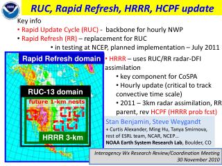
Hourly Updated NOAA NWP Models 13km Rapid Refresh domain • RUC – current oper model - 13km • Rapid Refresh (RR) – replace RUC at NCEP in 2010 - WRF, GSI w/ RUC-based enhancements • - Goes to 6-member ensemble in 2012-13 • HRRR - Hi-Res Rapid Refresh • Experimental 3km Current RUC CONUS domain 2009 3km HRRR domain
Rapid Refresh, HRRR, +0.5-1.0km HRRR subnests Rapid Refresh domain HRRR – 2010 demo for aviation impact Planned HRRR 1-km subnests (2-way boundary!) – testing RR/HRRR Applications – aviation, severe wx, renewable energy, AQ, fire, hydro Operational RUC-13 domain 2010 CONUS
RUC, Rapid Refresh and HRRR Time-lagged ensembles Rapid Refresh domain RUC-13 domain RUC– - RCPF = RUC Conv Prob Fcst HRRR – - HCPF = HRRR Conv Prob Fcst 2010 HRRR 3-km
GSI 3dvar GSI 3dvar Obs Obs RUC/Rapid Refresh Hourly Assimilation Cycle Cycle hydrometeor, soil temp/moisture/snow plus atmosphere state variables Hourly obs Data Type ~Number Rawinsonde (12h) 150 NOAA profilers 35 VAD winds 120-140 PBL – prof/RASS ~25 Aircraft (V,temp) 3500-10000 TAMDAR (V,T,RH) 200-3000 Surface/METAR 2000-2500 Buoy/ship 200-400 GOES cloud winds 4000-8000 GOES cloud-top pres 10 km res GPS precip water ~300 Mesonet (temp, dpt) ~8000 Mesonet (wind) ~4000 METAR-cloud-vis-wx ~1800 AMSU-A/B/GOES radiances Radar reflectivity/ lightning 1km 1-hr fcst 1-hr fcst 1-hr fcst Background Fields Analysis Fields Time (UTC) 11 12 13
3DVAR 3DVAR 3DVAR 3DVAR 3DVAR Obs Obs Obs Obs Obs RUC Hourly Assimilation Cycle - fall 2009 18-h fcst 18-h fcst 18-h fcst 18-h fcst 18-h fcst 18-h fcst Background Fields Analysis Fields Time (UTC) 11 12 13 14 15 16
Meso- and Storm-scale Probabilistic Forecasts from the RUC, Rapid Refresh, and HRRR • Original motivation for the crudest of ensembling: • Convection forecasts from RUC • Consideration for air-traffic management, QPF not accurate especially at fine resolution • Dilemma: • Niche=hourly NWP, no extra computer resources • Opportunity: • Strongly overlapping hourly-updated forecasts 18-h fcst 18-h fcst 18-h fcst 18-h fcst 18-h fcst 18-h fcst
RUC, Rapid Refresh and HRRR Time-lagged ensembles • RCPF = RUC Conv Prob Fcsthttp://ruc.noaa.gov/rcpf. • Running since 2004 through current (Oct 2008). • Runs hourly based on13km RUC run at ESRL. • Provides hourly updated 3,4,5,6,7,8,9h probabilistic forecasts of the likelihood of 40-dbZ radar echoes within a 40-km-side grid volume. • Gridded RCPF data provides guidance to NOAA Aviation Weather Center for the Collaborative Convective Forecast Product (CCFP) . • HCPF = HRRR Conv Prob Fcst • Running since June 2009 • Hourly updated based on 3km HRRR • http://ruc.fsl.noaa.gov/hcpf/hcpf.cgi
RCPF Prob > 35 dBZ HRRR Hourly updating model RUC RR Model-based probabilistic storm guidance Data Assimilation cycle Radar Assim Model post-processing HCPF Observations (HRRR-based) HCPF Storm-scale probabilityinformation Model time-laggedensembles Probability products
Reflectivity (dBZ) <20 20-30 30-40 40-50 50+ Spatial filter . . . . ... . . .. ... . . . ..... . . . ... . .. . . . . . . . . . . . . . . . . . . . . . . . . . Calculate probability: • Find fraction of points within box that exceed • the threshold • Example • Threshold > 30 dBZ • Probability = 7 / 21 • = 33 % - - -- -
RCPF bias corrections Multiply threshold by 0.6 over Western U.S. Lower threshold to increase coverage Higher threshold to reduce coverage GMT EDT Forecast Valid Time • Precipitation threshold adjusted diurnally • and regionally to optimize the forecast bias • Use smaller filter length-scale in Western U.S.
CCFP 15z +6h RCPF 13z +8h NCWD 4-km verification Valid 21z 20 Aug. 2007
6-h lead-time, 1 June – 31 Aug 2007 averageRCPF vs. CCFP CSI (skill) Bias Better CSI Very large bias Verified against 4-km NCWD GMT EDT Forecast Valid Time RCPF: Improved bias, better PM CSI
HCPF examplevalid 01z 21 July 2009 HCPF (4-hour lead) HRRR forecasts 19z+6 18z+7 16z+9 17z+8
17z + 4 hour CCFP: 15z + 6 hour HCPF: 16 July 2009 case study HCPF accurately placed a bulls eye over east-central NY CCFP missed this cluster of storms
17z + 4 hour CCFP: 15z + 6 hour HCPF: 16 July 2009 case study HCPF pinpoints the major areas of convection, avoiding excessive false alarms CCFP captures much of the convection, at the cost of a very high bias
Optimizing the HCPF algorithm Larger filter More ensemble members Optimal # of members is O(3-5): too few = low PoD, too many = low bias
Optimizing the HCPF algorithm Instantaneous reflectivity suffers from phase errors Using hourly maximum increases coverage better predictor HRRR reflectivity Hrly max HRRR refl Hrly max updraft
HCPF improvement from optimizing parameters - switch predictors - use diurnal threshold selection - reduce time-lag - optimize spatial filter size New HCPF 8-h forecasts Old HCPF CCFP
Verification results HCPFs for all of August 2009 comprising 6215 ensemble forecasts (all lead and valid times) Shows comparable skill to the CCFP Caveat: HCPF currently on smaller domain than CCFP (but is issued every hour unlike CCFP) CSI CCFP HCPF Probability Threshold
Variance of 250 hPa wind forecast ensemble from 4 forecasts (4h, 3h, 2h, 1h) Time-lagged-ensemble variance can be used to estimate wind forecast error 0.60 - correlation between variance/error Mean absolute wind vector error of 4-h forecast 00 UTC 23 Oct 2008 - using RUC
Coordinated Meso- and Storm-scale ensembles The NARRE and the HRRRE CURRENT (2009) • RUC • Non-WRF RUC model • RUC 3DVAR analysis • 24/Day = hourly update • Forecasts to 18 hours • 13 km horizontal • 50 layers with 50 mb top • Continuous forward cycle with no pre-forecast assimilation period • NAM • WRF-NMM (Egrid) • GSI analysis • 4/Day = 6 hr update • Forecasts to 84 hours • 12 km horizontal • 60 layers with 2 mb top • 12 hr pre-forecast assimilation period with 3hr updates (catch-up) RUC-13 CONUS domain 23
Coordinated Meso- and Storm-scale ensembles The NARRE and the HRRRE 2010-2011 • NAM • NEMS based NMM • Bgrid replaces Egrid • Parent remains at 12 km • Multiple Nests Run to 48hr • ~4 km CONUS nest • ~6 km Alaska nest • ~3 km HI & PR nests,and/or a~1.5-2km DHS/FireWeather/IMET are possible • Rapid Refresh • WRF-based ARW • NCEP’s GSI analysis (RR-version) • Expanded 13 km Domain to include Alaska • Experimental 3 km HRRR @ ESRL WRF-Rapid Refresh domain – 2010 RUC-13 CONUS domain Original CONUS domain Experimental 3 km HRRR 24 24
Coordinated Meso- and Storm-scale ensembles The NARRE and the HRRRE 2012-2013 • NAM/Rapid Refresh ENSEMBLE (NARRE) • NEMS-based NMMB and ARW cores & GSI analysis • Common NAM parent domain at 10-12 km (even larger than initial Rapid Refresh domain) • Initially ~6 member ensemble made up of equal numbers of NMMB- & ARW-based configurations • Hourly updated with forecasts to 24 hours • NMMB & ARW control assimilation cycles with 3 hour pre-forecast period (catch-up) with hourly updating • NAM 84 hr forecasts are extensions of the 00z, 06z, 12z, & 18z runs.
Coordinated Meso- and Storm-scale ensembles The NARRE and the HRRRE 2012-2013 • High-Resolution Rapid Refresh Ensemble (HRRRE) • Each member of NARRE contains • 3 km CONUS and Alaskan nests • Control runs initialized with radar data • Positions NWS/NCEP/ESRL to • Provide NextGen enroute and terminal guidance • Provide probability guidance • Improve assimilation capabilities with radar and satellite • Tackle Warn-on-Forecast as resolutions evolve towards ~1 km
Very Short-Range Ensemble Forecasts - VSREF - Updated hourly w/ available members valid at same time • RR – hourly • time-lagged (TL) ensemble members • 2012 - ensemble RR • ESRL 3km HRRR (incl. TL ensemble) • - 2012 - proposed HRRR at NCEP • future HRRRE from NARRE • NAM / NAM ensemble • GFS / GFS ensemble • SREF (updated every 6h) VSREF – Hourly Updated Probabilistic Forecasts = TL+ ensemble VSREF members Time-lagged ensemble provides skill baseline for evaluating HRRRE and NARRE development
VISION: Toward estimating and reducing forecast uncertaintyfor aviation applications using high-frequency data assimilation VSREF mems output for each AIV variable VSREF mems output - stat corrected For icing For icing HRRR VSREF- Model Ensemble Members - hourly (1h) updated Unified Post-processing Algorithms (modularized!!) for following: (multiple where appropriate), built on current WRFpost from NCEP Stat correction post- processing using recent obs Turb (e.g., GTG) Icing (e.g., FIP) Ceiling Visibility Convection ATM route options Wake vortex Terminal forecast Object diagnosis (line convection, clusters, embedded) Others… VSREF members - HRRR, RR, NAM, SREF, GFS, etc. Optimal weighting Explicit met variables from each VSREF member - V,T,qv,q* (hydrometeors),p/z, land-surface, chem, etc. Most-likely-estimate single value Potentially multiple variables under each Avx-Impact-Var (AIV) area Probability/PDF output
Meso- and Storm-scale Probabilistic Forecasts from the RUC, Rapid Refresh, and HRRR • Hourly updated ensemble forecasts: • Lessons learned and plans: • Original context for RCPF: convection forecasts • RCPF - provided automated convection product that matched CCFP, better for convective initiation • Spatial and temporal (time-lagged) averaging – both needed • Geographic and diurnal variations in accuracy – must be accounted for in averaging and bias correction • Time-lagged ensemble does provide temporal continuity to prob forecasts from hour to hour – desirable by forecasters • Formal hourly-updated ensembles are coming: • NAM/Rapid Refresh ensemble – 6 members • HRRR ensemble – 6 members • Time-lagged ensembling provides 3-4x multiplier, may or may not add value as “multiplier” to NARRE or HRRRE (only 6 members)
Hourly Updated Ensemble Forecasts – experience, plans • RCPF/HCPF TL ensemble experience • Plans for RR ensemble and HRRR ensemble • Recommendation: • Use merged time-lagged + formal ensemble members toward “HFProb” (High-Frequency Probabilistic Forecasts)
RUC and Rapid Refresh Real-time Rapid Refresh domain Current RUC-13 CONUS domain • Rapid Refresh • NCEP implement: • Planned summer 2010 • Features: • WRF-ARW w/ RUC physics • GSI assim (like NAM but w/ RUC enhancements) • Radar assim (like RUC)
RUC,Rapid Refreshand HRRR 13km Rapid Refresh domain RUC – NCEP upgrade 17 Nov 08 (Radar refl assim, TAMDAR aircraft). All runs to 18h- Fall09 RR – 2010 at NCEP 2 R/T cycles at GSD, full radiance assim, cloud anx + radar assimilation HRRR – FAA demo for aviation impact, radar assim from RUC, 12-h fcst each hour 13km RUC CONUS domain 2009 Exp HRRR domain
Mesoscale Uncertainty • Uncertainty varies for different different weather hazards • -- very high uncertainty for convection • -- • Uncertainty is scale and lead-time dependent • Uncertainty reduced by high-frequency assimilation
Desirable attributes for mesoscale probabilistic forecasts • Multiple models • Ensemble lateral boundary condition information • Optimally perturbed Initial conditions • Bias correction / Spatial filtering • Use of high frequency assimilation with radar data • Blending with nowcast systems for very short-range • Ensembling of extracted information relevant to problem
Diabatic Digital Filter Initialization (DDFI)in RUC model -30 min -15 min Init +15 min Backwards integration, no physics Forward integration, full physics Obtain initial fields with improved balance A recent frontier: Assimilation of radar reflectivity RUC model forecast
RUC, Rapid Refresh and HRRR Real-time Rapid Refresh domain • RUC– Major NCEP upgrade 17 Nov 2008 • Radar refl assim • TAMDAR RH • RR – Planned to replace RUC at NCEP in 2010 • HRRR – R/T demo for aviation impact • 12-h fcst each hour Operational RUC-13 domain 2008 2009 HRRR 3-km
RUC forecast accuracy higher with assimilation of recent observations 12h 6 9 3 1h Analysis ~ ‘truth’ Verification against RAOBs - Sept-Dec 2001
Diabatic Digital Filter Initialization (DDFI)add assimilation of radar data -30 min -15 min Init +15 min Backwards integration, no physics Forward integration, full physics Apply latent heating from radar reflectivity, lightning data Obtain initial fields with improved balance,divergent wind fields associated with ongoing convection A recent frontier: Assimilation of radar reflectivity RUC model forecast
HRRR reflectivity verification Skill vs. forecast length All HRRR forecasts W/ Radar assim CSI No Radar assim Forecast Length 30 dBZ reflectivity on HRRR 3-km grid Verification period 23 June – 25 Aug 2008 • Storm-scale modeling is not enough, must have radar reflectivity assimilation • Hourly updating is critical
Attributes Post-processing Techniques
VISION: Toward estimating and reducing forecast uncertainty for aviation applications using high-frequency data assimilation VSREF mems output - stat corrected VSREF mems output for each AIV variable For turb For turb HRRR VSREF- Model Ensemble Members - hourly (1h) updated Unified Post-processing Algorithms (modularized!!) for following: (multiple where appropriate), built on current WRFpost from NCEP Unified Post-processing Algorithms (modularized!!) for following: (multiple where appropriate) Stat correction post- processing using recent obs Turb (e.g., GTG) Icing (e.g., FIP) Ceiling Visibility Convection ATM route options Wake vortex Terminal forecast Object diagnosis (line convection, clusters, embedded) Others… VSREF members - HRRR, RR, NAM, SREF, GFS, etc. Optimal weighting Explicit met variables from each VSREF member - V,T,qv,q* (hydrometeors),p/z, land-surface, chem, etc. Most-likely-estimate single value Potentially multiple variables under each Avx-Impact-Var (AIV) area Probability/PDF output
VISION: Toward estimating and reducing forecast uncertainty for aviation applications using high-frequency data assimilation VSREF mems output - stat corrected VSREF mems output for each AIV variable For turb For turb HRRR VSREF- Model Ensemble Members - hourly (1h) updated Unified Post-processing Algorithms (modularized!!) for following: (multiple where appropriate), built on current WRFpost from NCEP Unified Post-processing Algorithms (modularized!!) for following: (multiple where appropriate) Stat correction post- processing using recent obs Turb (e.g., GTG) Icing (e.g., FIP) Ceiling Visibility Convection ATM route options Wake vortex Terminal forecast Object diagnosis (line convection, clusters, embedded) Others… VSREF members - HRRR, RR, NAM, SREF, GFS, etc. Optimal weighting Explicit met variables from each VSREF member - V,T,qv,q* (hydrometeors),p/z, land-surface, chem, etc. Most-likely-estimate single value Potentially multiple variables under each Avx-Impact-Var (AIV) area Probability/PDF output 4D-datacube
VISION: Toward estimating and reducing forecast uncertainty for aviation applications using high-frequency data assimilation VSREF mems output for each AIV variable VSREF mems output - stat corrected For turb For turb HRRR VSREF- Model Ensemble Members - hourly (1h) updated Unified Post-processing Algorithms (modularized!!) for following: (multiple where appropriate), built on current WRFpost from NCEP Unified Post-processing Algorithms (modularized!!) for following: (multiple where appropriate) Stat correction post- processing using recent obs Turb (e.g., GTG) Icing (e.g., FIP) Ceiling Visibility Convection ATM route options Wake vortex Terminal forecast Object diagnosis (line convection, clusters, embedded) Others… VSREF members - HRRR, RR, NAM, SREF, GFS, etc. Optimal weighting Explicit met variables from each VSREF member - V,T,qv,q* (hydrometeors),p/z, land-surface, chem, etc. Most-likely-estimate single value Potentially multiple variables under each Avx-Impact-Var (AIV) area SAS Probability/PDF output 4D-datacube
Key issues for improving the HCPF • Selecting best predictors • Predictor threshold for diurnal bias correction • Use of hourly “integrated” fields (phase errrors) • Optimal spatial filtering
HRRR Time-lagged ensemble - HCPF Model Init Time Example: 15z + 2, 4, 6 hour HCPF 18z 17z 16z 15z 14z 13z 12z 11z Model runs used 13z+4 12z+5 11z+6 13z+6 12z+7 11z+8 13z+8 12z+9 11z+10 model has 2h latency HCPF 2 4 6 11z 12z 13z 14z 15z 16z 17z 18z 19z 20z 21z 22z 23z Forecast Valid Time (UTC)
Optimizing the HCPF algorithm lower threshold larger filter bias CSI Perturbing detection threshold (red lines) has much larger impact on CSI and bias than spatial filter size
Optimizing the HCPF algorithm Early versions of the HCPF had inconsistent skill, with large bias swings throughout the diurnal convective cycle • Perform bias correction via a diurnally varying updraft (w) threshold • Find threshold values at each hour that achieve a fixed bias • Perform a Fourier synthesis to generate a smooth, analytic function for updraft velocity Diurnal convective maximum Diurnal convective minimum Convective initiation
16 July 2009 HCPF / HRRR overlay 15z + 6 hour HRRR and HCPF
HCPF summary Use of time-lagged ensemble from rapidly updating, convection resolving model yields a skillful convective probability product. Strengths: 1) Excellent performance (especially with traditional metrics) 2) Similar “look and feel” to existing products (CCFP, etc.) 3) Excellent product consistency 4) Can combine with deterministic CoSPA forecast to convey storm structure / convective mode and areas probabilities 5) Technique can be used to provide probabilistic forecasts of other high impact events (high wind, hail, tornadoes, flash flooding, heavy ice/snow)