Understanding Landforms: Mountains, Plains, Plateaus, and More
510 likes | 629 Views
Explore the fascinating world of landforms and geography with our comprehensive guide. Learn about plains, mountains, plateaus, and hills, including their characteristics and how they shape our planet. Discover key geographical terms such as rivers, climates, and maps, and understand the importance of economics and cultural history in shaping human interaction with land. This informative overview provides insights into primary and secondary sources, authenticity, and the fundamentals of cartography. Perfect for students and geography enthusiasts alike!

Understanding Landforms: Mountains, Plains, Plateaus, and More
E N D
Presentation Transcript
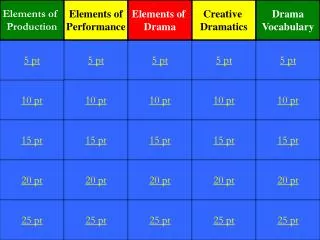
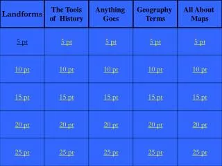
Landforms The Tools of History Anything Goes Geography Terms All About Maps 5 pt 5 pt 5 pt 5 pt 5 pt 10 pt 10 pt 10 pt 10 pt 10 pt 15 pt 15 pt 15 pt 15 pt 15 pt 20 pt 20 pt 20 pt 20 pt 20 pt 25 pt 25 pt 25 pt 25 pt 25 pt
An area o high steep rugged land. They rise to an elevation (or height) of at least 1,000 feet above the surrounding land.
An area of flat land that is higher than the surrounding land
These are areas of raised land, but they are lower, less steep and more rounded than mountains.
What two rivers make up the largest and most important river system in the United States.
What is The Mississippi River and the Missouri Rivers?
The study of how people manage their limited resources to satisfy their wants and needs is called
What do we call an account of history provided after the fact by people who did not directly witness or participate in the event? An example of a this source is a textbook, encyclopedia, books and articles written by historians.
What is a secondary source?
This term refers to whether or not the source is actually what it seems to be
What term do we use to describe an account of what happened in the life of different people?
This term describes the entire way of life that people have developed. It includes the behavior, customs, ideas, beliefs, and skills that people teach every new generation.
This term is firsthand information about people or events. It includes official documents such as laws or court decisions, public speeches, and eyewitness accounts such as diaries or letters, and autobiographies
This is the average weather of a place over a period of 20-30 years.
What term do we use to call businesses that are owned by private citizens. In this system the owners decide what products to make and sell.
The term we use to describe lines measured in degrees that run from north to south on a map
What is Longitude?
The term we use to describe lines measured in degrees that run from east to west on a map
This term is used to describe a drawing of the Earth’s surface
The name of the map that divides countries by land forms such as mountains and rivers
The type of map that shows how many people live in a part of the Earth