Download
1 / 17
170 likes | 273 Views
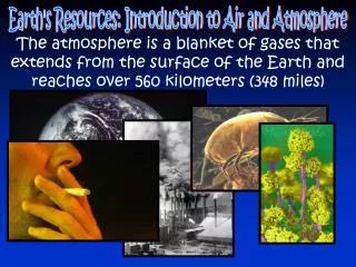
Explore the wonders of Earth's atmosphere through the lens of Apollo 17's iconic photo, unraveling features such as deserts, rainforests, cyclones, and more. Gain insight into climate change and the delicate balance of our planet.

E N D
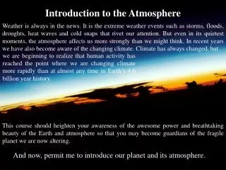
Introduction to the Atmosphere Weather is always in the news. It is the extreme weather events such as storms, floods, droughts, heat waves and cold snaps that rivet our attention. But even in its quietest moments, the atmosphere affects us more strongly than we might think. In recent years we have also become aware of the changing climate. Climate has always changed, but we are beginning to realize that human activity has reached the point where we are changing climate more rapidly than at almost any time in Earth’s 4.6 billion year history. This course should heighten your awareness of the awesome power and breathtaking beauty of the Earth and atmosphere so that you may become guardians of the fragile planet we are now altering. And now, permit me to introduce our planet and its atmosphere.
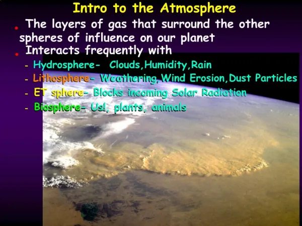
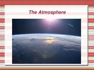
Apollo 17 View of Earth 08 Dec 1972 This famous photo, shown in almost every textbook on Astronomy, Meteorology, Oceanography, Geology, and Climatology contains an extraordinary amount of information about Earth and its atmosphere. Before you look at the key on the next slide and the descriptions on the slide after that, see how many features you can identify.
Atmospheric Features in the Photo 4 1. Africa 2. Kalihari Desert 3. Sahara Desert 4. Arabian Peninsula 5. Congo Rainforest 6. Antarctic Ice Sheet 7. Extratropical Cyclone 8. Tropical Rain Belt 9. Sahel 10. Sun Glint 11. Orographic Cloud 12. Tropical Cyclone 6 3 9 9 8 5 12 1 2 10 11 7 6
Major Features of Earth and Atmosphere Our perspective of the Earth and atmosphere has broadened from a narrow, local view of incomprehensible mystery to a comprehensive global picture. On December 8, 1972, the Apollo 17 astronauts photographed the Earth from space on their way to the Moon (Next slide). The photo contains a wealth of information about our planet and its atmosphere listed in the Key (Slide after next). The continent of Africa (1), largely surrounded by deep blue ocean, holds center stage. The golden regions are Africa’s great deserts, the Kalihari (2) and Namib in the southwest, and the Sahara (3) stretching across the width of northern Africa, and continuing in the Arabian peninsula (4). These deserts are largely confined between 20° and 30° latitude, in subtropical belts that contain most of the world’s great deserts. The broad, green band in the center of Africa houses the Congo Rainforest (5), which straddles the equator like all tropical rainforests. Much further south, bathed in the December sun, lies the white, ice-covered continent of Antarctica (6), outlined by a giant seam that distinguishes it from the surrounding sea ice and from clouds. The North Pole, out of sight at the top and cast into December darkness, is also covered with ice and snow. White clouds cover the globe in a variety of intricate patterns. Several large, comma-shaped cloud swirls occupy the ocean between Antarctica and Africa, and one covers Africa’s southern tip (7). They mark the low pressure areas called extratropical cyclones, that bring the middle and higher latitudes most of their stormy weather and supply Antarctica with its snow. The band of cloud spots and blotches over Africa’s green central band constitute the tropical rain belt or ITCZ (8) and include many towering thunderstorms. Few of these clouds venture over Africa’s deserts. Even the northern fringe of green land just south of the Sahara (9) is clear, for December is the dry season there since the sun and the tropical rain belt is centered south of the Equator where sun glint (10) brightens the water between Madagascar and Africa. The cloud line on the east Coast of Madagascar (11) shows that the trade winds strike the coast there and produce clouds and rain as they ascend the mountains. A small pinwheel cloud system resembling a spiral galaxy appears at the upper right (12), near the southern tip of India. This system is a tropical cyclone or hurricane and the dots are thunderstorms that are analogs to stars in galaxies. Its majesty from space contrasts with its destructiveness on Earth.
Some Important Terms Trade Winds: Tropical winds that blow toward the Equator from the east. Inter-Tropical Convergence Zone: (ITCZ) The zone (roughly parallel to the Equator) along which the Trade Winds converge and rise. TheITCZis marked by abundant convective clouds and showery rain. It is sometimes called the Tropical Rain Belt. Cyclone: A storm marked by low atmospheric pressure and characterized by counterclockwise (in the North Hemisphere), inward spiraling winds. Cyclones are generally regions of cloudiness and precipitation. Tropical Cyclone: A cyclone that forms over warm tropical waters (but not on the equator) marked by a central clear eye and spiral cloud bands. It has the appearance of a spiral galaxy with spiral bands containing thunderstorms. (Also called Hurricanes, Typhoons, Cyclones and Baguios) Extratropical Cyclone: A cyclone that forms outside the tropics when polar and tropical air masses collide. Marked by fronts. (Example - Blizzard) Front: An often stormy boundary line separating tropical and polar air masses
The Cause of Wind and Rain The Sun: The Source
Sunshine and Temperatures on Earth Solar energy available for heating is proportional to width of sunbeams striking a given area of ground 90 N Latitude 60 30 0 DAY NIGHT Sunlight variations over Earth produce variations of air temperature, density and pressure. The higher the Sun in the sky, the stronger its heating. The Tropics are warmer than the Poles because the Sun gets high in the sky every day in the Tropics but never does near the Poles.
Temperature Differences Drive the Winds When air is heated it expands. Warm air tends to rise because it is light. When air is cooled it contracts and becomes denser. Cold air tends to sink because it is dense. The Thermoscope Expansion and contraction of air caused by temperature changes are illustrated by the thermoscope, which is essentially an air thermometer. As the bulb is cooled the air inside contracts and draws the colored water up into the tube. When air is heated it expands, forcing water out of the tube (and some air if it is heated enough). THERMOSCOPE
Driving the Winds Differences of temperature, density and pressure from one place to another drive the winds. If the Earth did not rotate and its surface were uniform, each hemisphere would have a single circulation cell with warm, light, rising air at the equator and cold, dense, sinking air at the poles. But the Earth Does Rotate
Winds on the Rotating Earth Earth’s rotation breaks winds in each hemisphere into three cells or zones. 1. Tropical EW Trade Winds 2. Mid Latitude W E Winds 3. Polar E W Winds Cloudy, rising air prevails near Equator and 60° latitude Dry, sinking air prevails near 30° and 90° lat.
Coriolis ForceEarth’s rotation deflects movingair to its right (left) in the North (South) Hemisphere. Important Result: Tropical circulation (Hadley) Cells are created with rising air at the Equator, sinking air in the subtropics, and Trade Winds along the ground that are deflected to the West as they approach the Equator. CORIOLIS http://www.windows.ucar.edu/tour/link=/earth/Atmosphere/hadley_cell.html http://www.nodvin.net/snhu/SCI219/demos/Chapter_7/Chapter_07/Present/animations/50_1_2_1.html
Clouds, Rain, and Rising Air Rising air produces clouds and rain. But why?
Condensing Vapor – Producing Precipitation All clouds and rain are formed by the process of cooling air. As air cools its water vaporcapacity decreases. When vapor capacityfalls below the original vapor content the excess vapor condenses to form liquid water or ice. Vapor Capacity 20 13 12 9 12 7 6 9 7 6 Vapor Content 6 3 5 Cooling….Produces Condensed Water HOT COLD
The fastest way to cool air in the atmosphere is to make it rise. Thus...Most clouds and almost all precipitation are produced by rising air. To make most clouds and almost all precipitation 1. Air must rise 2. As air rises pressure, p decreases () 3. As p air expands and T. 4. As Tvapor capacity 5. With enough cooling, vapor capacity decreases below original vapor content so excess vapor condenses to form drops or crystals Air pressure decreases () with height because there is less air weighing down from above. In a pile of football players, the player on the bottom has the greatest pressure while the player on the top has the least pressure. The bottom player is squeezed most, and if he were made of air he would be compressed to the smallest volume. Compress
Overview of Africa’s Wind and Rain Rain Forest is located where air rises and deserts where air sinks.
Composite satellite map of Africa’s Vegetation with all clouds removed In Slides #4 and #15, we noted that Tropical rainforests straddle the Equator (0 latitude) while the Sahara and many of the world’s great deserts are located in the Subtropics between about 20 and 30 lat. We now explain these major climate features. Around the Equator, the air is hot and rises, making it rainy. The air that rises 30 over the Equator moves towards the Poles. But long before the air reaches the Poles, it cools and sinks in the Subtropics, producing deserts. The picture is complicated by the seasons. The Sun does not remain directly over the Equator all year but moves North and South. It stands directly overhead at 23.5 North Latitude on June 21, and directly overhead at 23.5South Latitude on Dec 21. This causes clouds of the Tropical Rain Belt to follow the Sun and migrate about the Equator (see next slide), producing distinct rainy and dry seasons in the Tropics, widening the Tropical Rainforest, but narrowing the Subtropical deserts (although they remain quite wide). 0 -30
24 January 2006 14 August 2011 Comparing two (METEOSAT) satellite images several months apart shows how the seasons affect climate. The Tropical Rain Belt (green ellipse) is South of the Equator in January and North of the Equator in August. Most of its clouds are spotty thunderstorms, with anvils typically less than 100 miles wide. The Mid Latitude Storm Belt is also further south in January and further north in August. NW Africa is covered by a winter storm with a comma-shaped front (red circle) in January but is clear in August, when storms are located further North over Europe. People throughout the tropics (and in North Africa) wait for the rainy season to come. But near the edges of their range, the rains are sporadic. If they fail to fall, drought, famine, and starvation follow.