Download
1 / 5
50 likes | 166 Views
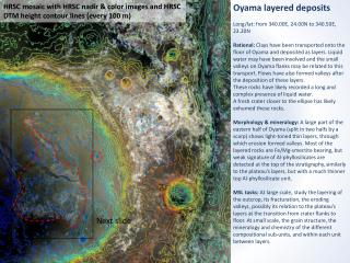
HRSC mosaic with HRSC nadir & color images and HRSC DTM height contour lines (every 100 m). Oyama layered deposits Long/lat: from 340.00E, 24.00N to 340.50E, 23.20N

E N D
HRSC mosaic with HRSC nadir & color images and HRSC DTM height contour lines (every 100 m) Oyama layered deposits Long/lat: from 340.00E, 24.00N to 340.50E, 23.20N Rational: Clays have been transported onto the floor of Oyama and deposited as layers. Liquid water may have been involved and the small valleys on Oyama flanks may be related to this transport. Flows have also formed valleys after the deposition of these layers. These rocks have likely recorded a long and complex presence of liquid water. A fresh crater closer to the ellipse has likely exhumed these rocks. Morphology & mineralogy: A large part of the eastern half of Oyama (split in two halfs by a scarp) shows light-toned thin layers, through which erosion formed valleys.Most of the layered rocks are Fe/Mg-smectite bearing, but weak signature of Al-phyllosilicates are detected at the top of the stratigraphy, similarly to the plateau’s layers, but with a much thinner top Al-phyllosilicate unit. MSL tasks: At large scale, study the layering of the outcrop, its fracturation, the eroding valleys, possibly its relation to the plateau’s layers at the transition from crater flanks to floor. At small scale, the grain structure, the mineralogy and chemistry of the different compositional sub-units, and within each unit between layers. Next slide
10 km HRSC mosaic with HRSC color images
495 The best eroded, exhumed part of these rocks have relatively high thermal inertia. Other dark, high thermal inertia rocks, possibly of volcanic origin, have filled the western half of the crater and the lowest parts of the valleys. 1 km J m-2 K-1 s-1/2 80 Next slide HRSC mosaic with THEMIS thermal inertia (Fergason, R. L.)
The entire light-tone rocks are finely layered (thickness of the order of one meter), and fractured in the same way as the plateau’s layered rocks. 1 km HiRISE image 17962_2035
200 m HiRISE image 17962_2035