DTM Generation Using LiDAR Data
This research explores the use of LiDAR (Light Detection and Ranging) technology in generating Digital Terrain Models (DTMs) to enhance 3D modeling and remote sensing applications. By leveraging airborne laser scanning, researchers can accurately capture topographical data, producing detailed DSMS and DTMs from reflected light pulses. These models serve critical functions in surveying, geodesy, and geomorphology, facilitating terrain analysis, project data calculations, and gravity measurements reduction. The study underscores the significance of automated data acquisition in modern cartography.

DTM Generation Using LiDAR Data
E N D
Presentation Transcript
DTM Generation Using LiDAR Data JUNGHUM YU School of Surveying & Spatial Information Systems The University of New South Wales, Australia
Introduction Automation in data acquisition for 3D models is an important topic of research in remote sensing. In addition to aerial images, point clouds generated by airborne laser scanning, are being used for that purpose more frequently. Airborne laser scanning is a comparatively recent technology for capturing data of the topography of the earth, which became feasible through the availability of lasers with special attributes and the Global Positioning System (GPS). In this method, the distance between an aircraft and the earth’s surface is measured by determining the travelling time of a light pulse. Junghum YU
LiDAR • LiDAR(Light Detection and Ranging) is an optical remote sensing technology which measures properties of scattered light to find range or other information of a distant target. • The first echo is reflected by the ground surface, hence by treetops, high-voltage transmission lines or roof ridges, the last echo mostly by the land underneath. A Digital Surface Model (DSM) is generated by the selection of the first echo. The last echos are the starting point for generating the Digital Terrain Model (DTM). Junghum YU
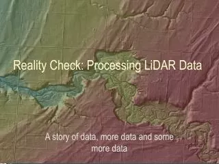
Digital Terrain Model A digital terrain model (DTM) is a topographic model of the bare earth that can be generated by special programs. The data contain the elevation of the terrain in a digital format which relates to grid. DTMs are used especially in surveying engineering, geodesy, geophysics, geography and remote sensing. The main applications are: • Visualization of the terrain • Calculation of project data • Reduction (terrain correction) of gravity measurements • Terrain analyses in Cartography and Geomorphology Junghum YU
DTM product Junghum YU
Brisbane Junghum YU
Fairfield Junghum YU