Download
1 / 14
140 likes | 445 Views
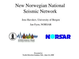
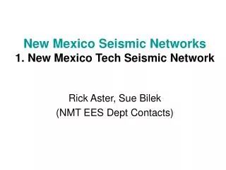
New Mexico Seismic Networks 1. New Mexico Tech Seismic Network. Rick Aster, Sue Bilek (NMT EES Dept Contacts). Stations within the NMT Seismic Network ( red ) Also shown stations: ANMO, SDCO ( blue stars , GSN stations) Not shown - 6 strong motion sites within Albuquerque area -- USGS .

E N D
New Mexico Seismic Networks1. New Mexico Tech Seismic Network Rick Aster, Sue Bilek (NMT EES Dept Contacts)
Stations within the NMT Seismic Network (red) • Also shown stations: ANMO, SDCO (blue stars, GSN stations) • Not shown - 6 strong motion sites within Albuquerque area -- USGS
NMT Network Statistics • 19 stations • Primarily short period (1 Hz) vertical component instruments • 2 3-component stations also running (only 1 currently operational) • Data telemetered via FM radio to the NMT Seismological Observatory • Stored using Earthworm system, sent to IRIS DMC (SC network)
Current Network Coverage • Focused on 2 areas • SE New Mexico • Monitoring of seismicity near the Waste Isolation Pilot Plant (WIPP) • Some funding provided by DOE/subcontractor to maintain this SE network • Socorro Seismic Anomaly • Region with ~50% of state’s seismic activity • In region of the Socorro Magma Body, small mid-crustal magma feature at 19 km depth • No long-term funding to support this network • Current funding to operate 2 temporary broad-band stations in SSA region (mid 2005-2006)
NM Seismicity • 1962-2004 • Sanford catalog (blue, magnitude > 2 thru 1998) + more recent data (red, magnitude: -1 to 4.6) • Most events concentrated in SSA
October 30, 2005 (UTC) felt earthquake swarm located approximately 5.5 km west of Socorro, included ~300 aftershocks. Largest event was magnitude 2.4. (www.ees.nmt.edu/Geop/recentquakes.html) Data
New Efforts In SSA region • Earthquake Locations (9/2005 - 1/2007) • Temporary installation of 2 new broadband seismographs to fill gaps in local seismic network coverage above the SMB (especially important for depth resolution).
NM State “Wish List” • 2-3 additional broadband stations • Targeted areas around northern NM, southern NM where there are gaps in current network coverage • Tie in to Los Alamos Seismic Network • Funds to create a dedicated “seismic observatory manager” for the state • Help coordinate all parts of the NM seismic networks (NMT, LANL, USGS) • Earthquake planning within DPS
2. Los Alamos Seismic Network • In operation since September, 1973 • 7 stations (16 channels) • 1 digital broadband (co-located with a 3-component short period seismometer) • 5 3-component short period seismometers • 2 vertical-only short period seismometers 6 (forensic) strong ground motion detectors located at key lab sites Current contacts: Peter Roberts, Jim TenCate, Leigh House (on leave) Earth and Environmental Sciences, Geophysics Group, LANL • 2 detection programs running concurrently: • X-detect (486 running DOS, yes, really!) • Earthworm 6.3 on Win XP
Issues • Fires • Funding • Vandalism • Lab sites • Security