Download
1 / 24
290 likes | 837 Views
The Lynmouth Flood 1952. Lynmouth Floods 1952. A flash flood! Was this natural disaster made worse by human activity? What lessons can be learned from the disaster?. Where is Lynmouth?. Location: Country: United Kingdom Region: South West England County: Devon

E N D
Lynmouth Floods 1952 • A flash flood! • Was this natural disaster made worse by human activity? • What lessons can be learned from the disaster?
Where is Lynmouth? Location: Country: United Kingdom Region: South West England County: Devon A small coastal town , Lynmouth is located in steep-side narrow valley at the confluence of two rivers – the East Lyn and the West Lyn.
What caused the flood? • Meteorology -The Weather • Combination of factors: • Dry summer up to early August • Period of heavy rain leading up to Aug 15th • Extreme rainfall event on August 15th • weather on line Image from BBC Devon
The Weather • Low pressure system centred over the South Devon/Dorset coast • A zone of warm damp air produced heavy thunderstorms during afternoon of Aug 15th • Late evening – the Low moved east & caused a rapid movement of cold air to force its way up the northern slope of Exmoor. • This cold air shunted the already unstable air upwards, accelerating uplift -chilling of damp air and produced violent downpour!
Early Afternoon • Thunderstorms – unstable warm air rising Exmoor – warm ground
August 15th 1952 Late Afternoon • Wedge of Cold Air • forces warm air upwards • Rapid Chilling • Rapid Condensation • Massive downpour • Saturated ground • RUN-OFF
Rainfall in August 1952 • Graph shows rainfall in the 2 days leading up to the disaster. • Peaks at 5pm on the 15th and 9pm on the 16th August • 230mms of rain in 14 hrs!
Rainfall on 15 August 1952 The map opposite shows the area of maximum rainfall Notice: Over 204mm on Longstone Barrow & ‘The Chains’ – area of moorland we visited Numerous tributaries feed East and West Lyn Rivers Rivers meet (confluence) at Lynmouth Figure from ‘Lyn in Flood’, Keene & Elsom, Oxford Brookes Univ.1990
What caused the flood? • Relief /Topography – the shape of the land • The Lyn Valleys are both narrow and steep sided • The rivers drop steeply from the moors of Exmoor • Both rivers meet at the end of the ‘drop’ at Lynmouth Image from Google Earth
What caused the flood? • Relief /Soils • The black, peaty, soils on Exmoor are very thin. • The heavy rain in August meant that they became saturated. • The rain falling on Aug 15th could not be absorbed by the soil and simply ran off, carrying the soil with it. The Moors (taken 4 Sept 2009)
The East Lyn Valley – our walk! Technocentric bridge Ecocentric bridge Watersmeet Notice the tight contours in the valley – evidence of steep slopes! Drop off point Extract from Lynton Lynmouth Walking Map. www.croydecycle.co.uk
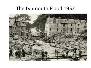
A Raging Flood in two confined valleys! • 13.6 million cubic meters of water fell on the drainage basin of the East and West Lyn Rivers. • The water surged down the valleys picking up boulders weighing 50 tonnes. • Rivers carried huge volume of soil from moors • Trees swept into rivers • Bridges formed natural dams – when they gave way a 12 meter high wall of water thundered through the town of Lynmouth. BBC report Pathe Newsreel
How did Lynmouth Change? Look the this map of Lynmouth as it was before the flood.
This is Lynmouth today Changes made to the town. Both river beds widened and deepened. Soak-away areas built into river channel Banks strengthened and reinforced Bridges designed to allow flow of much larger volumes of water. Buildings in high risk areas not replaced or demolished
Bridges –Ecocentric or Technocentric? Which bridge is designed to easily wash away and which is designed to resist a flood?
A very similar event!Boscastle Flood 2004 • Video News Report • http://www.youtube.com/watch?v=AszCGAETLt4&feature=player_embedde d