General Geology
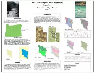
Mill Creek/ Umpqua River Watershed. Prepared by: Brenna Susee and Alyssa Marquez G.I.S. Physiography Cont

General Geology
E N D
Presentation Transcript
Mill Creek/ Umpqua River Watershed Prepared by: Brenna Susee and Alyssa Marquez G.I.S. Physiography Cont Recent timber harvests in the area have begun to occur, as also seen in Figure six, as the little light green areas. The climate is a Mediterranean climate with a wet winter and a dry hot summer. The area is very wet and the highest months for precipitation are November and December averaging about 11 inches. Precipitation annually ranges from high to low, low being 0.6in and high being 12in. The precipitation can be seen in figure 7. INTRODUCTION The Mill Creek/ Umpqua river watershed is located completely within Douglas County and covers about 348,166,100 m2. Which is in the southwestern region of Oregon. Figure 5. DRGs Figure 4. DEMs Figure 1. Map of Oregon and Mill Creek/Umpqua River Watershed Figure 9. Soils Figure 8. Geology (Bedrock) Hydrologic Summary The Water shed lies in three different Quads named, Deer Head Point, Scottsburg, Devils Graveyard, Elk Peak, Loon Lake, Old Blue, Golden Falls, Ivers Peak and Kelley Butte. There are two major rivers that feed the watershed the south and the north Umpqua rivers. There are over 26 sites where streams poor into or add to the Umpqua River. Watershed Location The watershed is located in Douglas county and flows from the Cascades until it reaches the end of Douglas county. The Umpqua river flows all the way to the ocean however the end of the river is not included in this watershed. It was formed through the North and South Umpqua rivers that drain off the cascades. This watershed and river flow through the coast range. It is located South of the Willamette Valley. Figure 10. Streams on Precipitation Figure 11. Streams Conclusions The Mill Creek/ Umpqua Watershed is mostly an area devoted to the Umpqua National Forest and the rest is farmland or becoming a place where clear cutting is very prevalent. There are many streams fueling this watershed and most of them are caused from run-off and snow melt. The watershed in located completely in Douglas, Co. and is a pretty large one as well. Figure 6. Vegetation Figure 7. precipitation Figure 2. Watershed Figure 3. Quad’s Watershed is located in. General Geology The four types of bedrock geology located in the watershed are OW, Tss, Tt, and Ty, marine sedimentary rocks located more in the northern part of the watershed near Elkton. The soils were formed through a mix of metamorphic, sedimentary and volcanic rock. Over more than 150 soil types have been identified in the region. The middle of the region is rich in deep alluvial or heavy clay materials and other areas are mixed alluvial, silt or clay structures. Physiography The elevation of the watershed changes from ~360 ft above sea level to at sea level, as shown in Figure 4, the digital elevation model. As you can see in Figure 6 a large area of the watershed’s vegetation mostly is comprised of Douglas Fir and Western Hemlock Trees. Mixed conifer and broadleaf deciduous forests cover the other large portion especially in the southwestern part of the watershed. References OregonGeology GIS Data: Dr. Taylor’s website Coast Watershed GIS Data: Dr. Taylor’s website Coast Streams GIS Data: Dr. Taylor’s website Precipitation GIS Data: Dr. Taylor’s website DEM GIS Data: UO Libraries DRG GIS Data: UO Libraries Roads GIS Data: ODOT Soil GIS Data: Soilmart