
Constructive and Destructive Forces
E N D
Presentation Transcript
What are Constructive and Destructive Forces? • Constructive Force • A constructive force is a process that raises or builds up the surface features of the Earth. • Destructive Force • A destructive force is a process that lowers or tears down the surface features of the Earth.
Surface features are landforms and bodies of water that cover the Earth’s surface such as: mountains valleys canyons gorges beaches sand dunes barrier Islands flood-plains moraines and drumlins volcanoes oceans lakes rivers What Are Surface Features?
ConstructiveForcesIdentify surface features caused by destructive forces. • Constructmeans to build up. • Forces that build up features on the surface of the Earth. • Sediment (Deltas, sand dunes, etc.) • Volcanoes (makes Islands) • Tectonic Plates (Mountains) • Crust deformation (Folding or Faulting)
Sediment • The process of sediment being carried causes new landforms. • Wind – sand transported by the wind creates sand dunes. • Water – bits of soil and rock can be carried downstream and deposited causing deltas. • Ice – glaciers pick up and move rock and other materials, depositing it elsewhere.
Volcano • http://app.discoveryeducation.com/search?Ntt=volcano+erupt • United Streaming-Fire Down Below
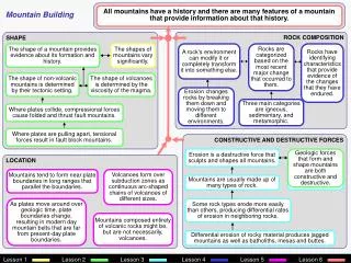
Volcanoes • A volcano is an opening in the Earth's surface or crust, which allows hot, molten rock, ash and gases to escape from deep below the surface. • Volcanic activity involving the extrusion of rock tends to form mountains or features like mountains over a period of time. • Magma (inside) • Lava (outside)
Volcanoes • There are two main types of volcanoes: shieldand composite. We will also learn about cinder cone volcanoes. • Shield volcanoes are usually found in the middle of tectonic plates. Islands like Hawaii are good examples of this type of volcano. These are making new islands every year…takes a long time. (Hawaiian Islands) • There's a hole in the middle of the plate and magma moves out and piles on top of itself, slowly building a mountain of rock. (Katmai)
Dome Mountains • Smaller bodies of magma can create dome mountains. • Formed when rising magma is blocked by horizontal layers of rock. The magma forces the layers of rock to bend upward into a dome shape.
Volcanoes 1. Magma reservoir2. Country rock3. Conduit (pipe)4. Base5. Sill6. Branch pipe7. Layers of ash emitted by the volcano8. Flank9. Layers of lava emitted by the volcano10. Throat11. Parasitic cone12. Lava flow13. Vent14. Crater15. Ash cloud
HOT SPOT • http://app.discoveryeducation.com/search?Ntt=hotspot • United Streaming-Hot Spot
Tectonic Plates • Mountains can be formed because of moving tectonic plates.
Types of Stresses • Tension is a force that pulls on the plates of Earth’s crust causing them to move apart. • Compression is a force that pushes on the plates of Earth’s crust causing them to move together. • Shearingis a force that pushes on the plates of Earth’s crust causing one to move in one direction and the other plate in the opposite direction
Faults • Faults are cracks in the Earth’s crust. • The surface of the Earth is made up of tectonic plates that are floating on magma (molten rock). • It is along these fault lines that earthquakes and volcanoes occur.
Types of Faults Normal Fault Reverse Fault Strike-Slip Fault Caused by tension forces where plates diverge (Divergent boundary) Caused by compression forces (convergent boundary) Caused by shearing (transform boundary)
Mountain Building • Forces of plate movement can build up earth’s surface. Over millions of years, fault movement can change a flat plain into a towering mountain range.
Mountains formed by Faulting • When normal faults uplift a block of rock, a fault-block mountain forms.
Mountains formed by Folding • Bends in rock that form when compression shortens and thickens part of Earth’s crust is called folding. Certain conditions can cause plates to move and the crust to fold. • The Himalayas in Asia and the Alps in Europe were formed like this.
DestructiveForcesIdentify examples of surface features caused by destructive processes. • Destruct means to destroy. • Forces that destroy features on the Earth’s surface. • Erosion (water - rivers and oceans, wind) • Weathering (chemical or mechanical) • Impact of organisms • Earthquake
Earthquakes • An earthquake is a phenomenon that results from the sudden release of stored energy in the Earth’s crust. • It is caused by a strain on the fault lines of the Earth’s crust. When the energy of the strain is released, similar to a rubber band snapping, the earthquake occurs. • At the Earth's surface, earthquakes cause a shaking or displacement of the ground and sometimes cause the ground to break apart and change shape. Earthquake Animation!
Weathering and Erosion • Weatheringis the breakdown of the continents and the land around you. The breaking down of these rocks and land due to forces such as wind and water is weathering. When it rains, rocks are washed down a mountain or down a stream. Soils are washed away. The ocean beats against a cliff and breaks it apart. If it is moved elsewhere it is called erosion.
Earthquakes • More than buildings collapse when an earthquake hits. The land itself is totally changed. You can see scars across the landscape. Those scars appear when one block of land has moved compared to another. Roads often change their placement. They either become uneven or just crack. Streams can also change course. Sometimes rocks can fall and block the stream. Other times, the land is even lowered in certain areas. When it's lower, it's easier for the water to flow in the new direction .
Earthquakes • San Andreas Fault line is 810 miles and runs along California. It separates the tectonic boundary of the Pacific and North America boundary.
Tsunamis • When an earthquake jolts the ocean floor, plate movement causes the ocean floor to rise slightly and push water out of its way. • Displaced water can form large waves, called tsunamis.
Technology andHuman Interventions • Humans try to CONTROL these forces. • seismological studies • flood control (dams, levees, storm drain management, etc.) • beach reclamation (Georgia coastal islands)
Seismic Waves • Scientists study earthquakes so that they can understand how they work and so that they can try to predict future quakes. • Earthquakes are recorded by instruments called “seismographs”. • A short wiggly line means a small earthquake and a large one means a large earthquake.
Seismic Waves • These are waves of energy that travel through Earth’s layers studied by geologist. • Primary (P waves) travel fast • Secondary waves (S waves) travel through solids
Flood Control • The U.S. Army Corps of Engineers began constructing dams in Georgia for navigation and flood control in the 1940s and 1950s under the Flood Control Act of 1944 and the Watershed Protection and Flood Prevention Act of 1954. Lake Allatoona was created in 1950 by the U.S. Army Corps of Engineers for flood control. At more than 12,000 acres, Allatoona is one of the larger lakes in the state.
Flood Control Methods • Dams control the water flow in a stream or river. • A levee is an embankment designed to prevent the flooding of a river. • Storm drains are for carrying off rainfall drained from paved surfaces, roofs, etc.
Beach Reclamation • Weather, waves and wind cause the coastline to wash away. • Keeping sand dunes intact helps to keep the beaches from eroding.
Some examples of constructive and destructive forces in the world….