GPS: Global Positioning System
GPS: Global Positioning System. Mike T. Friggens Sevilleta LTER. GPS Basics. What is GPS?. How does it work?. What is GPS?.


GPS: Global Positioning System
E N D
Presentation Transcript
GPS: Global Positioning System Mike T. Friggens Sevilleta LTER
GPS Basics • What is GPS? • How does it work?
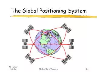
What is GPS? • The Global Positioning System (GPS) is a precise worldwide radio-navigation system, and consists of a constellation of satellites and their ground stations, operated and maintained by the US Department of Defense (DoD). • NAVSTAR GPS (Navigation Satellite Timing and Ranging system) 24 Satellites orbiting the earth • Positioning, navigation and timing • Operates 24 hrs/day, in all weather • Can be used for any application that requires location information
GPS Segments Space Control User
Space Segment: GPS Satellites • Power • Sun-seeking solar panels • Nicad batteries • Timing • 4 atomic clocks
Satellite Orbits • 24 satellites in 6 orbital planes • Orbit the earth at approx. 20,200 km (11,000 nautical miles) Satellites complete an orbit in approximately 12 hours Satellites rise (and set) approximately 4 minutes earlier each day
Satellite Signals • GPS satellites broadcast messages via radio signals on 2 frequencies • L1: 1575.42 Mhz (C/A and P/Y code) • L2: 1227.60 Mhz (P/Y code) • Two levels of service • Standard Positioning Service (SPS) • Precise Positioning Service (PPS)
Satellite Signals, cont. • Satellite signals require a direct line to GPS receivers • Signals cannot penetrate water, soil, walls or other obstacles
Satellite Almanac ******** Week 269 almanac for PRN-01 ******** ID: 01 Health: 000 Eccentricity: 0.5405902863 E-002Time of Applicability(s): 61440.0000 Orbital Inclination(rad): 0.9813845822 Rate of Right Ascen(r/s): -0.7577458489E-008SQRT(A) (m 1/2): 5152.601074 Right Ascen at Week(rad): 0.3902550488E+000 Argument of Perigee(rad): -1.695816885 Mean Anom(rad): -0.1712506416E+001 Af0(s): 0.3681182861E-003 Af1(s/s): 0.3637978807E-011 week: 269 ******** Week 269 almanac for PRN-03 ******** ID: 03 Health: 000 Eccentricity: 0.6181240082E-002 Time of Applicability(s): 61440.0000 Orbital Inclination(rad): 0.9281326789 Rate of Right Ascen(r/s): -0.8000333246E-008SQRT(A) (m 1/2): 5153.644531 Right Ascen at Week(rad): -0.2857742542E+001 Argument of Perigee(rad): 0.554986085 Mean Anom(rad): -0.7420111497E+000 Af0(s): 0.5340576172E-004 Af1(s/s): 0.3637978807E-011 week: 269 • Sent along with position and timing messages • Prediction of all satellite orbits • Needed to run satellite availability software • Valid for about 30 days
Colorado Springs Hawaii Kwajalein Ascension Diego Garcia Control Segment: US DoD Monitoring
Colorado Springs Hawaii Kwajalein Ascension Diego Garcia U.S. DoD Monitoring • Orbits are precisely measured • Discrepancies between predicted orbits (almanac) and actual orbits are transmitted back to the satellites
How Does GPS Work? Calculating a Position • GPS receiver calculates its position by measuring the distance to satellites (satellite ranging)
Measuring Distance to Satellites • 1. Measure time for signal to travel from satellite to receiver • 2. Speed of light x travel time = distance • Distance measurements to 4 satellites are required to compute a 3-D position (latitude, longitude and altitude)
difference Time Measuring Travel Time of Satellite Signals • How do we find the exact time the signal left the satellite? • Synchronized codes
One measurement narrows down our position to the surface of a sphere
A second measurement narrows down our position to the intersection of two spheres
A third measurement narrows down our position to just two points
Correcting for Timing Offset • The first three measurements narrow down our position • A fourth measurement is needed to correct for timing offset (the difference in synchronization between satellite and receiver clocks)…
4 Measurements: 4 Variables • Latitude • Longitude • Altitude • Time
More Sources of Error • Gravitational pull of other celestial bodies on the satellite, affecting orbit • Atmospheric effects: Signals travel at different speeds through ionosphere and troposphere. • Obstruction • Multipath: Bouncing of signals may confuse the receiver • Selective Availability – Not as of 2000 • Satellite Geometry: GDOP, PDOP…
Geometric Dilution of Precision (GDOP) • GDOP Components • PDOP = Position Dilution of Precision (3d measure for acceptability of signal quality) • “PDOP mask” typically set @ 6; lower is better > 8 poor) • HDOP = Horizontal Dilution of Precision (Latitude, Longitude) • VDOP = Vertical Dilution of Precision (Height) • TDOP = Time Dilution of Precision (Time)
Poor GDOP, a large value representing a small unit vector-volume, results when angles from receiver to the set of SVs used are similar • Good GDOP, a small value representing a large unit-vector-volume, results when angles from receiver to SVs are different
Differential GPS (DGPS): • The use of a second GPS receiver located at a fixed and known point to remove or minimize the effect of some of the sources of position error.
Rover GPS Receiver Fixed Base Station Portable Base Station Differential GPS (DGPS) cont.
Choosing a GPS Receiver: 4 Questions • What features (real world items) will I be mapping? • What are my project accuracy needs? • What GIS resources (skills) do I have available? • How much money do I have? …
Finally, Other Global Navigation Satellite Systems (GNSS) • GLONASS • Russia • Galileo • European Union
Useful URL’s (Acknowledgements) • http://www.trimble.com/index.html • http://www.colorado.edu/geography/gcraft/notes/gps/gps_f.html • http://www.nps.gov/gis/gps/gps4gis/assessing.html • http://www.montana.edu/places/gps/ • http://www.ncgc.nrcs.usda.gov/branch/risb/technical/gps/dgps.html • http://www.navcen.uscg.gov/dgps/coverage/Default.htm • http://www.google.com