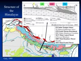
Galy, 1999
S. LH. HHC. TSS. Structure of the Himalayas. Modified from Lavé & Avouac, 2001. ITS Indus Tsangpo Suture TS Tethyan Sedimentary Series STD South Tibetan Detachment HHC Higher Himalayan Crystalline MCT Main Central Thrust LH Lesser Himalayas MBT Main Boundary Thrust Siwaliks

Galy, 1999
E N D
Presentation Transcript
S LH HHC TSS Structure of the Himalayas Modified from Lavé & Avouac, 2001 ITS Indus Tsangpo Suture TS Tethyan Sedimentary Series STD South Tibetan Detachment HHC Higher Himalayan Crystalline MCT Main Central Thrust LH Lesser Himalayas MBT Main Boundary Thrust Siwaliks MFT Main Frontal Thrust Galy, 1999
S LH HHC TSS Structure of the Himalayas Modified from Lavé & Avouac, 2001 ITS Indus Tsangpo Suture TS Tethyan Sedimentary Series STD South Tibetan Detachment HHC Higher Himalayan Crystalline MCT Main Central Thrust LH Lesser Himalayas MBT Main Boundary Thrust Siwaliks MFT Main Frontal Thrust
S LH HHC TSS Structure of the Himalayas Modified from Lavé & Avouac, 2001 ITS Indus Tsangpo Suture TS Tethyan Sedimentary Series STD South Tibetan Detachment HHC Higher Himalayan Crystalline MCT Main Central Thrust LH Lesser Himalayas MBT Main Boundary Thrust Siwaliks MFT Main Frontal Thrust Looking South towards the high summits
S LH HHC TSS Structure of the Himalayas Modified from Lavé & Avouac, 2001 ITS Indus Tsangpo Suture TS Tethyan Sedimentary Series STD South Tibetan Detachment HHC Higher Himalayan Crystalline MCT Main Central Thrust LH Lesser Himalayas MBT Main Boundary Thrust Siwaliks MFT Main Frontal Thrust
A HUGE normal fault in the middle of the largest mountain range on Earth!!! STD S N TSS HHC
S LH HHC TSS Structure of the Himalayas Modified from Lavé & Avouac, 2001 ITS Indus Tsangpo Suture TS Tethyan Sedimentary Series STD South Tibetan Detachment HHC Higher Himalayan Crystalline MCT Main Central Thrust LH Lesser Himalayas MBT Main Boundary Thrust Siwaliks MFT Main Frontal Thrust
S LH HHC TSS Structure of the Himalayas Modified from Lavé & Avouac, 2001 ITS Indus Tsangpo Suture TS Tethyan Sedimentary Series STD South Tibetan Detachment HHC Higher Himalayan Crystalline MCT Main Central Thrust LH Lesser Himalayas MBT Main Boundary Thrust Siwaliks MFT Main Frontal Thrust
S LH HHC TSS Structure of the Himalayas Modified from Lavé & Avouac, 2001 ITS Indus Tsangpo Suture TS Tethyan Sedimentary Series STD South Tibetan Detachment HHC Higher Himalayan Crystalline MCT Main Central Thrust LH Lesser Himalayas MBT Main Boundary Thrust Siwaliks MFT Main Frontal Thrust This is the very front of the Himalayas! MFT
III. Erosion controls the structure of mountains? 2) The curious case of the Himalayas Puzzling: a huge plateau behind the range and a gigantic normal fault in the middle of the range?! Localization of erosion could explain both features… The growth of the Himalayas did affect profoundly atmospheric circulation monsoon + aridification of the zone North of the main divide Bookhagen and Burbank, 2006
Arid Tibetan plateau: erosion << uplift the range widens + extrusion (Tapponnier et al., 2001)
Why the Tibetan plateau is not getting higher? Tapponnier, 1982
Tibetan Plateau: crustal thickness ~70 km • partial melting of the lower crust • ductile behaviour, very low “coefficient of friction” • can’t build up topo! Lithospheric cross-section (Tapponnier et al., 2001)
III. Erosion controls the structure of mountains? 2) The curious case of the Himalayas Puzzling: a huge plateau behind the range and a gigantic normal fault in the middle of the range?! Localization of erosion could explain both features… Bookhagen and Burbank, 2006 Rainfall focused at the front of the range focused erosion focused exhumation?
S LH HHC TSS Modified from Lavé & Avouac, 2001 Lavé & Avouac, 2001: maximum fluvial erosion rate in the HHC zone for 6 main Himalayan rivers
S LH HHC TSS Lavé & Avouac, 2001: maximum fluvial erosion rate in the HHC zone for 6 main Himalayan rivers Modified from Lavé & Avouac, 2001
Can focused erosion lead to focused exhumation? Beaumont et al., 2001
PHYSICAL MODELLING Can focused erosion lead to focused exhumation? Erosion Erosion Erosion Chemenda et al., 1995
NUMERICALMODELLING Can focused erosion lead to focused exhumation? Beaumont et al., 2001: the CHANNEL FLOW theory demijohn.co.uk
Erosion rate: H high (> 14 mm/yr), M medium (4-14 mm/yr) or L low (< 4 mm/yr). Effective internal angle of friction for the upper crust: 5 or 15 degrees. Upper crustal rheology: viscosity with respect to Wet Quartzite Flow Law (WQz).
NUMERICALMODELLING Can focused erosion lead to focused exhumation? Beaumont et al., 2001: the CHANNEL FLOW theory S LH HHC TSS Modified from Lavé & Avouac, 2001 Good agreement between model, thermochronologic and PTt data! But why is the angle of friction for the upper crust so low, and where is the channel flow now? (the MCT is now inactive…)
IV. To which extent does erosion affect deformation in mountains? “Revisiting river anticlines”. Montgomery and Stolar, 2006
Montgomery and Stolar, 2006 Unloading local rebound / uplift. Can be isostatic (passive) or fed by channel flow (active: focused erosion focus exhumation)
IV. To which extent does erosion affect deformation in mountains? “Revisiting river anticlines”. The growth and development of Himalayan river anticlines are not explained well by classical explanations for relationships between river courses and geological structure. Re-examination of the potential role of differential bedrock erosion suggests that rivers appear able to influence the development of geological structures where there are sustained gradients in erosion rate and either a crustal rigidity low enough to permit localized isostatic rebound, or where facilitated by active feedback between tectonic and erosional processes such as that leading to channeling of crustal flow. Consequently, rivers may be the authors not only of their own valleys, but in some circumstances of the structural geology of the surrounding mountains as well. Montgomery and Stolar, 2006