Download
1 / 16
160 likes | 323 Views
MERSEA Remote – Sensing Ocean Portal. http://www.mersea.eu.org < Observing Systems < Remote Sensing. Brest 21-22 Nov 2005 WP2.6 - DIP2 Project Status. WP2.6 and DIP-2 Activities To be conducted / Conducted yet (1/2). The general objective of the 2.6 task is to coordinate all efforts in

E N D
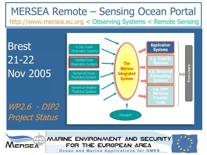
MERSEA Remote – Sensing Ocean Portal http://www.mersea.eu.org< Observing Systems < Remote Sensing Brest 21-22 Nov 2005 WP2.6 - DIP2 Project Status
WP2.6 and DIP-2 Activities To be conducted / Conducted yet (1/2) The general objective of the 2.6 task is to coordinate all efforts in remote sensing data availability and distribution. • A WWW site will be developed as a portal to the different independent systems and to facilitate the visibility and exchange of the data in a reliable and coherent manner • The portal will provide an overview of all available remote sensing data and an easy access to the data sets through a link to the relevant data distribution servers. • The second phase will tackle the problem of documenting all products(lists of products, formats, user guides, tutorials) • The second phase will tackle the problem of providing gridded data products for all mission – SST, sea ice and ocean color) in a Netcdf structure format using the same ocean convention such as COARDS/CF and distribute them in an OPeNDAP catalogue Nov 2005
WP2.6 and DIP-2 Activities To be conducted / Conducted yet (2/2) The general objective of the 2.6 task is to coordinate all efforts in remote sensing data availability and distribution. • The second phase will tackle the problem of setting up well defined or revised interface procedures (with partners and other WPs) • The WWW remote sensing data portal will berun in a shared and distributed mode. • A Mersea LAS will be implemented to federate Opendap servers. • The second phase will tackle the problem of implementing an overall control capability (monitoring kits). • The second phase will tackle the problem of running a web site to keep updated information and post new information (cf. actualities, R&D reports) Nov 2005
Check-List • Identify your product lines • Register/update your product line (discovery metadata) • Fill in/ update the system monitoring table • Update your documentation • List of products (record above information) • User manual (see template on examples on …) • User tutorial (see template and examples on ….)
User Tutorial (information on the web) – template under preparation – For more information (useful links) • Mersea Data Center web site, Product web site, Data distribution server, Viewing service • More links: cf. direct links on satellite center or projects wrt to the ocean parameter use Overview • Mission (text + image per §) • Products • Services • Satellites and useful characteristics • How we measure the « ocean parameter » of interest (SSH, SST, SSR, Sea Ice) • « Ocean parameter » usefulness for ocean monitoring • Multiple satellites for high precision « Ocean Parameter » • Applications (+ link to forecast systems, the place to input data) • References Summary Cards • ID Card:short name, version long name, hierarchy, type of product: NRT/DT • Operational card: configuration, resolution, qualification process, history file, production schedule • Quality card:indicators, metrics Products Introduction Oceanic variables Resolution Period of supply Time parameters Format Size (MB) Distribution Access conditions => Discovery metadata file Project Activities • Summary • Activities • First Year Results • Research and Development • Documentation • Presentations
WP2.6 and DIP-2 ActivitiesFollow on -Open Issues • Services & High level functionalities ? System ambition • System Versions ? & Timeframe Deploiement level • Second Distribution Review When ? What for ? • Monitoring and assessment report for phase 2 • Who are the users feedback for new products and services enhancements • Refine crosscutting functions • Products refined wrt geographical targets & forecasting systems
Assessment for V1 SystemTEP / Data Centers Overview * Follow on of Strand-1
Assessment for V1 SystemInteroperability charter - product * Quality rate => 3 levels : quality, performance, accuracy
Assessment for V1 SystemInteroperability charter - distrib * Quality rate => 3 levels : quality, performance, accuracy
Assessment for V1 SystemBusiness charter * For operationality and validation demonstration