Download
1 / 23
230 likes | 395 Views
Stream Monitoring in Loudoun County. David Ward, Water Resources Engineer Department of Building and Development, Water Resources Team Loudoun County, Virginia For Goose Creek Association “State of the Creek” Middleburg, VA March 12, 2009. Purpose.

E N D
Stream Monitoring in Loudoun County David Ward, Water Resources Engineer Department of Building and Development, Water Resources Team Loudoun County, Virginia For Goose Creek Association “State of the Creek” Middleburg, VA March 12, 2009
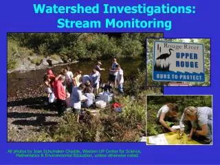
Purpose • Summarize water resources programs and hydrologic monitoring • Highlight stream monitoring (citizens, government agencies such as Loudoun County, and Loudoun Soil and Water Conservation District) • Stream impairments (“Listing” by VA Dept Environmental Quality)
Water Resources Programs • Water Resources Monitoring Program (2001-2009) • Strategic Watershed Management Solutions (2005-2006) • Comprehensive Watershed Management Program (2006-2008) • Wetlands Modeling (2006-2008) • Stream Assessment (2009)
Water Resources Monitoring Program (WRMP) TYPES OF DATA COLLECTED OR INCORPORATED: Precipitation/Rainfall Stream Stage & Discharge Stream Water Quality Groundwater Level Groundwater Quality Stream Assessment Stream Monitoring
Water Resources Monitoring Program (WRMP) DATA SOURCES: National Weather Service U. S. Geological Survey Dept. of Building & Development Environmental Health permitting Hydrogeologic studies for subdivision VA DEQ Metro Wash. Council of Governments Volunteer groups
Recent Streamflow in the Creeks Height of water in stream Flow rate in stream http://waterdata.usgs.gov/va/nwis/uv?dd_cd=01&dd_cd=02&format=gif&period=7&site_no=01638350
Since 1972 Since 1910 Since 1966 Over 2.6 million stream flow readings , 15-minute in realtime
Obtained from USGS: http://va.water.usgs.gov/duration_plots/dp_map_potomac.htm
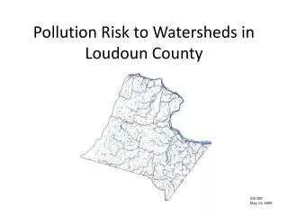
Watershed Assessment • Comprehensive overlay analysis of watershed metrics including: imperviousness, water quality, population projections, karst, land use, forest, stormwater age, etc. • Goose Creek ranges from “maintain” in headwaters to “improve” in lower Goose Creek
Volunteer Stream Monitoring • Began in late 1990’s with Loudoun Soil and Water Conservation District, Loudoun Wildlife Conservancy, Audubon Naturalist and others. • In 2000 Stream Monitoring Project memorandum of understanding that was rebranded to Loudoun Watershed Watch. • Loudoun Watershed Watch partners monitored 249 times 1997-2007 using ANS protocol. • Goose Creek Association monitored 272 times 2003-2009 using VA SOS protocol. • In 2008 Loudoun Wildlife Conservancy changed to VA SOS protocol. http://www.loudounwatershed.org
Monitor Assess “List” Impairment TMDL TMDL Implementation Plan Implement (Restoration) Monitor & Delist Water Quality Assessment and TMDLs • Every two years VA DEQ conducts Water Quality Assessment • Based on monitoring reaches of creek are assessed for criteria and if levels are exceeded, the reach is “listed” as being impaired • Once “listed”, DEQ is required to find out the source of the pollution and write a TMDL (Total Maximum Daily Load) report • After the source determination, DEQ may figure what can be done to correct in TMDL Implementation Plan • The Plan establishes the corrective action and funding • Based on the plan government (Dept Health and/or Dept Conservation & Recreation) oversee conducting the plan, often through Soil Water & Conservation District
VA DEQ Surface Water Quality • Ambient and trend stations for Chemical (N, P,Zn, Cu, pH, etc) and biological (E. Coli) • Over 44,000 measurements since early 70’s in Goose Creek watershed at 56 stations http://gisweb.deq.virginia.gov/monapp/mon_query_form.cfm
Example: Monthly Median Total Phosphorus North Fork Goose Creek is often higher in fall, but are still below criteria
VA DEQ Benthic Monitoring • Benthic monitoring (Code name “ProbMon EDAS “) • More involved than VA SOS • Over 50 measurements in Goose Creek since 1994 at 14 stations and over 5,000 statewide http://www.deq.virginia.gov/probmon/products/
Subcategory 3 - Insufficient Data Goose Creek Data in 2008 Reference letter February 15, 2008 to Hazle Edens. 22 stations with 132 sample events Based on review of protocols and methods, dissolved oxygen, pH, temperature, and E. coli data are acceptable for VA Category 3C and 3D purposes. Dissolved oxygen was not accepted due to malfunctioning equipment. • Virginia 3A - No Data Available • Virginia 3B - Data Available But Insufficient Quantity • Virginia 3C - Citizen Monitoring Indicates Problem • Waters Evaluated And Prioritized For Follow-Up Monitoring • Virginia 3D - Citizen Monitoring Indicates No Problems http://www.deq.virginia.gov/wqa/pdf/2008ir/appendices/ir08_AppendixD_Data_Sets_Considered.pdf
New in 2008 – You can select which type of impairment: • Aquatic life (benthic-sediment) • Fish consumption • Public water supplies • Shellfish consumption • Recreation or swimming (bacteria) • Wildlife http://gisweb.deq.virginia.gov/adbims/viewer.htm
North Fork Beaverdam Creek 08 Goose Creek 98 Little River 98 Aquatic Life - Benthic Red Impaired Green Supporting (OK) Blue No data Wancopin Creek 08
David Warddavid.ward@loudoun.gov703-737-8670www.loudoun.gov/streamassessment