Download
1 / 15
170 likes | 423 Views
Virginia Geology. 2011. Basic Landforms. Mountains : Natural elevation of the land. Hill : Small natural elevation of the land. Plains : A large area of flat land free from forests and mountains. Plateaus : Large, flat area of land that is higher than the surrounding land.

E N D
Virginia Geology 2011
Basic Landforms • Mountains: Natural elevation of the land. • Hill: Small natural elevation of the land. • Plains: A large area of flat land free from forests and mountains. • Plateaus: Large, flat area of land that is higher than the surrounding land. • Watershed: Ridge or crest dividing two drainage areas. • River Basin: A round, low area of land surrounded by higher land.
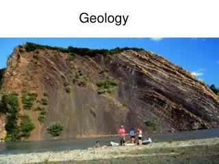
Each province has unique features. Coastal Plain • Land is relatively flat and gently slopes to the ocean • Ground is made mostly of sedimentary rocks. There is also lots of sand, clay and gravel (sediments). This comes from the erosion of the Appalachian Mountains. • Mining of the sand, clay and gravel is an important resource. • Youngest land of all the provinces • Large tidal rivers: James, Potomac, Rappahannock and James
Piedmont • The largest of all the provinces. • Ground is made mostly of Metamorphic rocks. These rocks formed as the Appalachian Mountains were created by the rifting (splitting apart) of Pangaea. • Contains the Fall Line on the Eastern border. The fall line is rapid drop in elevation. There are many rapids and waterfalls along the fall line. • Major rivers: Anna, James, Rappahannock and Roanoke.
Blue Ridge • The Blue Ridge Mountains contain some rocks that are over 1 billion years old. • Ground is made mostly of Igneous rocks. • The Blue Ridge Mountains formed as Pangaea (where North America and Africa are today) smashed together (lots of volcanic activity). This action caused the rocks to be pushed up and on top of the Valley and Ridge Province. • Major Rivers: Roanoke, James, Anna and Rappahannock.
Valley and Ridge • Made of long parallel ridges and valleys that were created by the folding and faulting of rock (during Appalachian Mountains formation). • Ground is made mainly of sedimentary rock, some of which have carbonates (limestone's) on top. • Many caves and sinkholes are found in the limestone regions of the Valley and Ridge province. Natural bridge and Luray Caverns are examples. • Major Rivers: Jackson (turns into James) and New River.
Appalachian Plateau • The smallest province located to the far west of the state. • Valleys and Ridges become smaller so the land is still rugged and hilly. There are many streams and valleys. • The ground is made up of sedimentary rocks (much like the valley and ridge province). • Many mineral deposits of coal, petroleum and natural gas are mined from this province. • Major Rivers: None
Chesapeake Bay Formation Virginia has 5 physiographic provinces produced by past tectonic and geologic activity. Each province has unique physical characteristics resulting from its geologic past. Virginia has a billion year long tectonic and geologic history. Provinces extend from Georgia to New York. Chesapeake Bay formed from the flooding of the Susquehanna river and was impacted by a meteorite.
Watersheds • A watershed is an area that is separated by a ridge or crest (divide) allowing the water to drain. • Land can be divided into major and minor watersheds (there can be a watershed in another watershed).
The US is divided into 3 major watersheds: The Atlantic, Mississippi and Pacific.