Download
1 / 14
140 likes | 164 Views
Explore ozone products, transition to national centers, new developments, and future goals for enhanced weather forecasting. Learn the importance of Air Mass RGB validation and how to interpret ozone anomalies.

E N D
Ozone and Ozone Anomaly Science Advisory Committee Meeting 26 – 28 August, 2014 National Space Science and Technology Center, Huntsville, AL
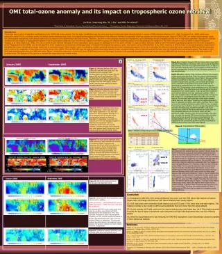
1 Outline • Forecast Challenge & Motivation • Ozone Products • Transition to National Centers • New Product Development • Future Goals • Further Air Mass RGB Validation • Summary Top: AIRS total column ozone Bottom: AIRS ozone anomaly
2 Forecast Challenge & Motivation • OPC has used the Air Mass RGB product since 2012 • To enhance forecaster situational awareness of cyclogenesis and stratospheric driven high wind events • As a proxy to prepare for GOES-R ABI capabilities • The GOES-R/JPSS PG satellite liaison and National Center forecasters expressed a need for quantitative products to enhance understanding and training of the qualitative RGB • SPoRT specializes in unique applications of NASA data Suspected stratospheric dry air drawn into mid-latitude cyclone
3 Forecast Challenge & Motivation • Legacy AIRS ozone retrievals can be used to • Enhance interpretation and increase forecaster confidence in the Air Mass RGB before GOES-R launch • Demonstrate capabilities of next-generation JPSS CrIS retrievals • SPoRT has worked with GOES-R/JPSS Proving Grounds to develop/transition ozone products in N-AWIPS format to OPC Suspected stratospheric dry air drawn into mid-latitude cyclone AIRS O3 provides confidence stratospheric air present
4 Ozone Products • SPoRT produces 2 products in image and gridded format: • Total Column Ozone • Ozone Anomaly • Product is provided in hourly swaths: • Products have a 4-hour latency to utilize all granules • Advantage is hemispheric coverage for OPC’s domain AIRS O3 gridded format overlaid on MODIS RGB product • AIRS data obtained from NASA Land Atmosphere Near Real-time Capability for EOS (LANCE) with latency between 60 and 200 minutes AIRS O3 image format on NW hemisphere domain
5 Example 12 May 2013 • SPoRT MODIS Air Mass RGB shows a region of red/orange coloring surrounding the low pressure center • AIRS Total Column Ozone confirms high ozone values • How do we know if these high ozone values represent stratospheric air or are within the climatological range? Suspected stratospheric air (red/orange) Missing values due to clouds High ozone values (red/orange)
6 Ozone Anomaly Product • Ozone varies seasonally and spatially: • High ozone values could still range within climatology • High ozone values could be misinterpreted as stratospheric • The AIRS Ozone Anomaly product clarifies the presence of stratospheric air based on: • Van Haver et al. 1996: Stratospheric air has ozone values at least 25% larger than the climatological mean • Ziemkeet al. 2011: Global and zonal monthly mean climatology of stratospheric ozone derived from the NASA Microwave Limb Sounder Blue shading of values ≥ 125% confirms high O3 represent stratospheric air
7 Example 12 May 2013 • SPoRT AIRS Ozone Anomaly product created as a percent of normal (0-200%) • Shades of blue represent stratospheric air (ozone values Suspected stratospheric air (red/orange) Blue shading confirms stratospheric air High ozone values (red/orange)
8 Transition to National Centers • AIRS ozone products evaluated at OPC, WPC, SAB winter 2013-2014 • Forecaster Feedback • “Reinforce the evidence from RGB of the descent of stratospheric air with tropopause folding.” • “This has allowed me to have confidence in assessing the RGB Airmass product and also in conjunction with gridded GFS output that a perceived PV anomaly is real or not.” High ozone values > 400 DU suggest potential vorticity anomaly and descending stratospheric air creating high winds near the comma head SEVIRI RGB Air Mass image, AIRS Total Column Ozone (green contours), and ASCAT winds valid at 1400 UTC on 12/18/13. The black circle highlights the descending stratospheric intrusion near the comma-head/bent back front. Image courtesy of Michael Folmer Satellite Liaison at NOAA/NWS WPC/OPC/TAFB and NOAA/NESDIS SAB
9 New Product Development 1500 UTC • Expanding suite of ozone products to include CrIS • Initial use of CrIMSS until NUCAPS CrIS is available • Data obtained from SSEC PEATE server at an 8-hour latency to produce hourly swaths on a hemispheric domain • Hopefully NUCAPS CrIS ozone retrievals will be transitioned to OPC Fall 2014 • How will including CrIMSS increase temporal and spatial coverage compared to using only AIRS? CrIMSS Total Column O3 14 May 2014 1700 UTC CrIMSS Total Column O3 14 May 2014
10 New Product Development 1500 UTC 1400 UTC • Demonstrates increased temporal coverage of GOES-R ABI • Spatial coverage now includes most of the North Atlantic • Differing latencies still problematic • Need to refine the display of CrIMSS to match AIRS Similar O3 feature & Coverage farther west AIRS Total Column O3 14 May 2014 CrIMSS Total Column O3 14 May 2014 1700 UTC 1600 UTC Coverage farther west & shows where feature ends AIRS Total Column O3 14 May 2014 CrIMSS Total Column O3 14 May 2014
11 Future Goals • Current training includes a quick guide • expand forecaster training to include a short module • Make the products available in AWIPS-II • Currently funded joint SPoRT/CIRA/CIMSS GOES-R visiting scientist project to explore products in National Centers Perspective AWIPS-II • Adjust product according to forecaster feedback after the winter demonstration at OPC • Expand the ozone products to other instruments • Increase temporal & spatial coverage with AIRS, IASI, CrIS retrievals once NUCAPS is available • Work with NESDIS STAR to generate anomalies from their TOAST/TACO products which combine UV/IR ozone retrievals “There may have been 1 occasion where 1 pass did line up over the US with the spot I was interested in. In that case, it was helpful in reaffirming my suspicions on whether stratospheric air was present. Otherwise, the passes were few and far between and not particularly timely. If there was greater coverage of passes and not as much of a lag, it would certainly be useful.”
12 Further Air Mass RGB Validation 1812-1824 UTC 29 October 2012 AIRS O3 Anomaly • Use of profiles to further validate RGB products in preparation for GOES-R ABI • Would forecaster access to profiles/swaths on individual levels enhance confidence and interpretation of qualitative products? 1801 UTC 29 October 2012 GOES Sounder Air Mass RGB Mid- & Upper- level Dry Air High O3 down to ~250 mb 1812-1824 UTC 29 October 2012 AIRS T, q, O3 profiles
13 Summary • SPoRT has worked with GOES-R/JPSS Proving Grounds to develop/transition ozone products in N-AWIPS format to OPC • Legacy AIRS ozone retrievals have been used to enhance interpretation and increase forecaster confidence in the Air Mass RGB before GOES-R launch as well as demonstrate capabilities of next-generation JPSS CrIS retrievals • Based on forecaster feedback SPoRT plans to expand the ozone products to other instruments to increase temporal and spatial coverage