Download
1 / 34
340 likes | 362 Views
Explore the Earth's layers, tectonic plates, continental drift theory, and evidence of Pangaea. Learn about plate movements, boundaries, and the Rift Valley theory. Engage in the fascinating world of Earth's geological wonders!

E N D
Earth’s Layers The Earth's rocky outer crust solidified billions of years ago, soon after the Earth formed. This crust is not a solid shell; it is broken up into huge, thick plates that drift atop the soft, underlying mantle.
The Crust • Outermost layer • 5 – 100 km thick • Made of Oxygen, Silicon, Aluminum
The Mantle • Layer of Earth between the crust and the core • Contains most of the Earth’s mass • Has more magnesium and less aluminum and silicon than the crust • Is denser than the crust
The Core • Below the mantle and to the center of the Earth • Believed to be mostly Iron, smaller amounts of Nickel, almost no Oxygen, Silicon, Aluminum, or Magnesium
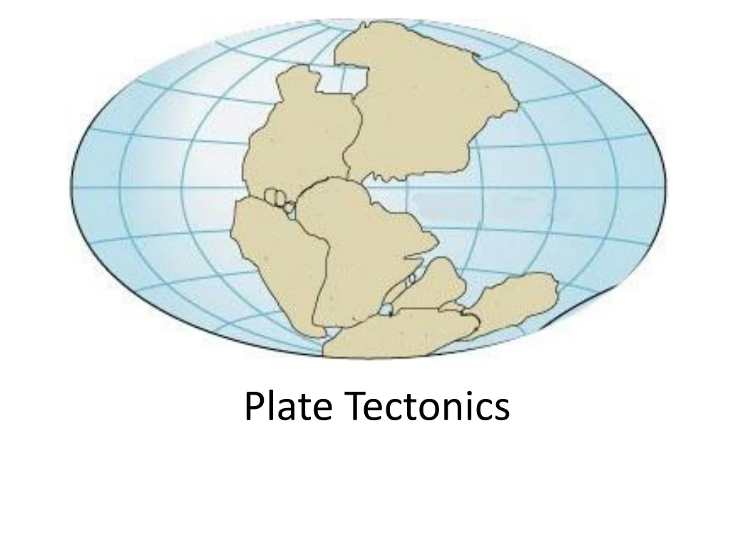
Plate Tectonics • Greek – “tektonikos” of a builder • Pieces of the lithosphere that move around • Fit together like jigsaw puzzles. • Float on top of mantle similar to ice cubes in a bowl of water.
Drifting Continents Theory • Wegener suggested that a supercontinent he called Pangaea had existed in the past. • It broke up starting 200 million years ago, and the pieces ``drifted'' to their present positions. • He cited the fit of South America and Africa, ancient climate similarities, fossil evidence (such as the fern Glossopteris and mesosaurus), and similarity of rock structures.
Wegener ‘s hypothesis • All continents were once together in a single landmass and have since drifted apart. • In 1915, Wegener published a book called the “Origin of Continents and Oceans.”
Continental Drift Alfred Wegener 1900’s Continents were once a single land mass that drifted apart. Fossils of the same plants and animals are found on different continents Called this supercontinent Pangea, Greek for “all Earth” 300 Million years ago Split again – Laurasia & Godwin 180 million years ago http://members.enchantedlearning.com/subjects/astronomy/planets/earth/Continents.shtml
Evidence of Pangaea • Fossil or any trace of an ancient organism. • Fossil preserve in rocks. • Glossopteris( fernlike plant ) lived 250 million years ago. • Freshwater reptiles (Mesosaurus and Lystrosaurus )
Evidence of Pangaea • Climate , as continents move toward the poles, its climate is colder. • As continents move toward the equator, its climate gets warmer. • Fossils of tropical plants were found in the Arctic Ocean. ( Spitsbergen)
Sea Floor Spreading • Mid Ocean Ridges – underwater mountain chains that run through the Earth’s Basins. • Magma rises to the surface and solidifies and new crust forms. • Older Crust is pushed farther away from the ridge. • MOR lie under thousands of meters of water.
Sea Floor Spreading • Mid- ocean ridges continually add new material ( CRUST ) to the ocean floor. • Subduction is a process by which the ocean floor sinks beneath a deep ocean trench and back into the mantle again.
How Plates Move http://pubs.usgs.gov/gip/dynamic/unanswered.html
Different Types of Boundaries http://pubs.usgs.gov/gip/dynamic/understanding.html
Divergent Boundary – Arabian and African Plates Arabian Plate Red Sea African Plate
Divergent Boundary – Iceland http://pubs.usgs.gov/gip/dynamic/understanding.html
Divergent Boundary - Oceanic http://www.geology.com
Divergent Boundary - Continental http://www.geology.com
Convergent Boundary – Indian and Eurasian Plates Eurasian Plate Indian Plate
Convergent Boundary – Oceanic & Continental http://pubs.usgs.gov/gip/dynamic/understanding.html & http://www.geology.com
Convergent Boundary – Oceanic & Oceanic Note – plates are reversed http://pubs.usgs.gov/gip/dynamic/understanding.html & http://www.geology.com
Convergent Boundaries - Continental http://pubs.usgs.gov/gip/dynamic/understanding.html & http://www.geology.com
Transform Boundary – San Andreas Fault www.geology.com
Trench Puerto Rico Trench Depth 800 m. Length 8,000 m.
Theory of Plate Tectonics • Earth’s plates are in slow constant motion, driven by convection currents in the mantle.
Review • Name the 3 main layers of the Earth • What is a tectonic plate? • What was Pangaea? • What is Sea-Floor spreading? • Name the three different types of plate boundaries and one location on Earth for each one.


