Download
1 / 12
120 likes | 337 Views
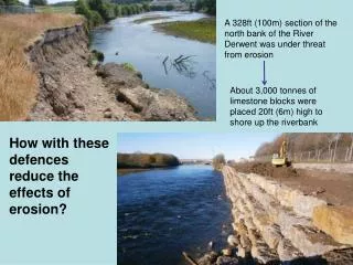
A 328ft (100m) section of the north bank of the River Derwent was under threat from erosion. About 3,000 tonnes of limestone blocks were placed 20ft (6m) high to shore up the riverbank. How with these defences reduce the effects of erosion?. Cumbrian Floods of 19 th Nov 2009!.

E N D
A 328ft (100m) section of the north bank of the River Derwent was under threat from erosion About 3,000 tonnes of limestone blocks were placed 20ft (6m) high to shore up the riverbank How with these defences reduce the effects of erosion?
The site of cockermouth • http://www.bing.com/maps/default.aspx?q=&mkt=en-GB&FORM=BYFD#JnE9LkNvY2tlcm1vdXRoJTI1MmMlMmJDdW1icmlhJTdlc3N0LjAlN2VwZy4xJmJiPTU0LjczNDQ1OTYwMTI2NyU3ZTEwLjA3Njc5Nzk2MjYyNSU3ZTQ3LjkyNzc2MTEwNzkyODQlN2UtMTAuMjQ3OTA5MDY4NjI1
Why did it happen? • PHYSICAL FACTORS: These were the main reasons for the flood: • 1. A weather front stopped over N.W. England and led to the highest amount of rainfall ever recorded in England! 378mm of rain fell in 34 hrs (takes 8 months for that amount to fall in London!). • 2. Steep slopes quickly transferred water in to the rivers. • 3. Cockermouth is sited at the confluence of the R.Cocker and the R. Derwent. • 4. Rocks are inpermeable here and soils were already saturated after heavy rains previously experienced.
Activity: What were the physical causes of the flooding? • Put the map of Cumbria in the centre of a double page and annotate with detail from the clips and page 104-105 of the text book. • You need to include information on the following: • 1. What caused all the rain? • 2. How much rain actually fell and where? • 3. What were the antecedent conditions of the ground like? • 4. What are the physical features of the drainage basin like? ( You might like to use an atlas to help!) Think about relief/topography of the land, geology, drainage patterns. • Now add detail about the possible human causes of the flooding. • Again use all the resources available to you and think about the land uses of the area.
Impacts • This flood was a 1 in 1000 year flood event and it was forecast by the Met office, but is was more devastating than predicted. • 1300 homes flooded, • Power supplies shut off and schools closed, • Several bridges collapsed, cutting off communities. All 1800 of Cumbria’s bridges had to be inspected as a result, • Insurance companies had over £100 million worth of claims, • Farm land was covered in river sediment and animals lost, • Local businesses, such as shops, pubs and hotels had to close, losing money. • Which are social, economic or environmental?
Responses • 200 people had to be airlifted from roofs by RAF helicopters or rescued by boats, • Many residents had to be re-housed for several months, • Small businesses were provided with trading accommodation in the town centre, while their premises were refitted. Many roads in the town were so badly damaged that they had to be re-surfaced. • In nearby Workington Network rail built a new station to connect residents from each side of the town, cut off by collapsed bridges, • A new bridge destroyed in the floods (leading to the only death) was rebuilt in the following few months. • 6 months later:
Impacts/ Effects: 1.Social P.106 Cumbrian floods of 2009 Impacts/ Effects: 2. Economic P.106 and plastic handout Impacts/ Effects: 3. Environmental Responses: Short term Responses: Long term – P.106 Medium term – following months
Flood risk mapsWho would find this map useful?Can you think of any negative impacts of these maps? Use Tomorrow’s Geography P.76 – How can people be prepared for flooding?
How can we manage river flooding? • The people of Cockermouth blamed the authorities of ‘putting salmon before people’, after a request to lower the river bed by 3 metres was turned down as it might harm fish! • How could this have reduced the risk of flooding? • What other techniques could they have used? • Draw a quick mind map of your ideas, discuss them with your neighbour.