Download
1 / 18
180 likes | 294 Views
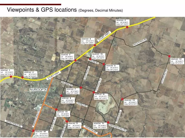
Viewpoints & GPS locations (Degrees, Decimal Minutes). Method. 10 Megapixel Olympus Digital Camera with 14-42mm lens Viewpoints taken at 42mm Theory varies as to the zoom which is most equivalent to the human eye (generally 35mm-50mm)

E N D
Method 10 Megapixel Olympus Digital Camera with 14-42mm lens Viewpoints taken at 42mm Theory varies as to the zoom which is most equivalent to the human eye (generally 35mm-50mm) Each viewpoint pegged and numbered (as shown) and GPS reference point taken (Degrees, Decimal Minutes)
Viewpoint 1 – Sturt Highway Latitude 34° 27.509’ S Longitude 138° 57.947’ E
Viewpoint 2 – Sturt Highway Latitude 34° 27.610’ S Longitude 138° 58.509’ E
Viewpoint 3 – Sturt Highway Latitude 34° 26.809’ S Longitude 139° 1.293’ E
Viewpoint 4 – Sturt Highway Latitude 34° 26.142’ S Longitude 139° 2.372’ E
Viewpoint 5 – Sturt Highway Latitude 34° 25.382’ S Longitude 139° 3.925’ E
Viewpoint 6 – Cnr Stockwell & Pipeline Rds Latitude 34° 26.957’ S Longitude 139° 2.762’ E
Viewpoint 7 – Cnr Light Pass & Kalimna Rds Latitude 34° 27.949’ S Longitude 139° 1.560’ E
Viewpoint 8 – Cnr Research & Penrice Rds Latitude 34° 28.304’ S Longitude 139° 0.578’ E
Viewpoint 9 – Cnr Light Pass & Angaston Rds Latitude 34° 29.392’ S Longitude 139° 0.862’ E
Viewpoint 10 – Cnr Barossa Valley Hwy & Seppeltsfield Rd Latitude 34° 29.816’ S Longitude 138° 59.114’ E
Viewpoint 11 – Breakneck Hill Rd Latitude 34° 29.480’ S Longitude 139° 2.949’ E
Viewpoint 12 – Moculta Rd Latitude 34° 28.462’ S Longitude 138° 03.724’ E
Viewpoint 13 – Cnr Bastion Hill & Duck Ponds Rd Latitude 34° 26.641’ S Longitude 139° 6.152’ E
Viewpoint 14 – Cnr Research & Angaston Rd Latitude 34° 28.908’ S Longitude 139° 0.328’ E
Viewpoint 15 – Cnr Pipeline & Light Pass Rd Latitude 34° 26.759’ S Longitude 139° 2.067’ E
Viewpoint 16 – Cnr Stockwell & Kalimna Rd Latitude 34° 28.174’ S Longitude 139° 2.255’ E