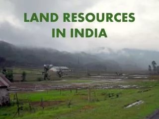
LAND RESOURCES IN INDIA
890 likes | 3.53k Views
LAND RESOURCES IN INDIA. AN OVERVIEW. AN OVERVIEW. North to South : 3,214 Kms . & East to West : 2,933 Kms. Land Frontier : 15,200 Kms . & Coast-line : 7,517 Kms. Arabian Sea. Bay of Bengal. Laccadive Sea. INDIAN OCEAN. Ladakh. Karakoram Range. Punjab Plain &

LAND RESOURCES IN INDIA
E N D
Presentation Transcript
LAND RESOURCES IN INDIA
AN OVERVIEW North to South : 3,214Kms. & East to West : 2,933Kms. Land Frontier : 15,200 Kms. & Coast-line : 7,517 Kms. Arabian Sea Bay of Bengal Laccadive Sea INDIAN OCEAN
Ladakh Karakoram Range Punjab Plain & Thar Desert Aravalli Range Himalayan Mountain Range Chin & Kachin Hills Malwa Plateau INDO- GANGETIC PLAIN Khasi & Mizo Hills Satpura Range Chhot-nagpur Plateau Runn of Kutch Vindhya Range Sunderban Arabian Sea Deccan Plateau Eastern Ghats Bay of Bengal Western Ghats Laccadive Sea INDIAN OCEAN
LAND RESOURCES IN INDIA UTILISATION FROM TRANSPORT SECTOR
MAJOR LAND USERS IN TRANSPORT SECTOR RAILWAYS- Railway Tracks, Stations, Workshops, Godowns, etc. ROADWAYS- Roads, Fuel Pump Stations, Toll Plazas, Utilities, etc. AIRWAYS- Airports, Runways, Workshops, etc. WATERWAYS- Ports, Workshops, Godowns, etc.
ROAD SECTOR TOTAL ROAD NETWORK : 4.69 Mn. Kms. THIRD LARGEST NETWORK DENSITY : 0.66 Km./Sq. Km. NHs : 79,739 Kms.(Appx.) SHs : 1,63,898 Kms.(Appx.) OTHER PWD ROADS URBAN ROADS RURAL ROADS PROJECT ROADS
SERVICE ROADS PARALLEL SERVICE ROADS FOR 2-WAY TRAFFIC SHOULD BE PLANNED AS ESSENTIAL PART OF ANY SCHEME FOR ERECTING BUILDINGS & FACTORIES ON THE LAND ABUTTING THE HIGHWAY. TRANSPORT DEVELOPMENT COUNCIL’S RECOMMENDATION STATE GOVERNMENTS COULD ENSURE BY STIPULATING CONDITION WHILE GRANTING PERMISSION FOR BUILDINGS/FACTORIES
CONTROL OF BUILDING ACTIVITY ROAD WIDTH (No Structure) BUILDING LINE (No Building Activity) CONTROL LINE (No Building above 13 Mtrs.)
EXISITING PRACTICE LAND IS A SUBJECT INCLUDED IN STATE LIST CENTRAL GOVERNMENT IN MINISTRY OF ROAD TRANSPORT AND HIGHWAYS IS MANDATED FOR BUILDING, MAINTENANCE, MANAGEMENT & OPERATION OF NATIONAL HIGHWAYS
NATIONAL HIGHWAYS ACT, 1956 (48 of 1956) Section 2 – Declaration of National Highways sub-section (1) – NHs Specified in Schedule sub-section (2) – Provision for Addition of new NHs sub-section (3) – Provision for Omission of existing NHs Section 4 –National Highways to vest on Union includes- (i) All Lands appurtenant thereto, whether demarcated or not; (ii) All Bridges, culverts, tunnels, causeways, carriageways & other structures; (iii) All fences, trees, posts and boundary, furlong & mile stones of such highways or any land appurtenant to such highways.
CRITERIA FOR DECLARATION OF NATIONAL HIGHWAYS :- • Roads running through the length and breadth of the country; • Roads connecting adjacent countries; • Roads connecting the National Capital with State Capitals • and roads connecting mutually the State Capitals; • Roads connecting major ports, non-major ports, large • industrial or tourist centers; • Roads meeting very important strategic requirement in • hilly and isolated areas; • Arterial roads enabling sizeable reduction in travel distance • and achieve substantial economic growth thereby;
Roads which help opening up large tracts of backward • area and hilly regions(other than strategically important ones); • National Highways grid of 100 km is achieved; • The road must be upto the standard laid down for SHs - • both in its technical requirements and land requirements; • Existing Right of Way(RoW) should be the property of the • State Govt. and must be generally free of encroachments; • RoW required for NHs must be available for acquiring, free • of encroachments and the State Govt. would complete • acquiring formalities within six months. If additional RoW • is required for developing the road to NH standards, the • State Govt. would complete the acquisition expeditiously • after sanctioning of estimates therefor.
Processing Proposals for declaration of NHs are finalised in consultation with M/o Finance & Plg. Commission M/o Finance concurs from expenditure angle involved In future development of the NHs to be declared • Plg. Commission considers :- • Available infrastructure; • Justification for such declaration; • Formation of National Highways Grid; • Overall & balanced development of NHs; • Financial aspect during the relevant Plan Period.
STEPS OF LAND ACQUISITION FOR NH Under Section 3 of NH Act, 1956 3.(a) – Authorisation of Competent Authority 3A – Power to acquire land for NH - Intention notified 3B – Power to enter into land for Survey, etc. 3C – Hearing of Objections, received in writing within 21 days 3D – Declaration of Acquisition within one year - Land shall vest absolutely in Central Govt. - Not questionable in any Court of law
3E – Power to take Possession by 60 days Notice - Provision of enforcement through Law & Order 3F – Legal right to enter into land for works 3G – Determination of Amount of Compensation - Notice to Claimants - Factors taken into consideration spelt out - Provision of Arbitration 3H – Deposit & Payment of Compensation - Provision for referring disputes to Civil Court
SCOPE FOR IMPROVEMENT ON CARDS :- EXPRESSWAYS - CONTROLLED-ACCESS HIGHWAYS • SIX OR EIGHT LANE HIGHWAYS • CONTROLS ENTRY & EXIT • SLIP ROADS FOR ENTRY & EXIT • DESIGN OF SLIP ROADS INCORPORATED • IN THE DESIGN OF HIGHWAY • HIGHEST CLASS IN INDIAN ROADS NETWORK
16 E-WAYS OPERATING - 942 Kms. • 16 MORE UNDER CONSTRUCTION - 2702 Kms. • ALL E-WAYS AS KNOWN TO US ARE NOT • E-WAYS IN TRUE SENSE, AS THESE DO NOT • HAVE ACCESS CONTROL • ACCESS CONTROL = TOLL COLLECTION
EXISTING NATIONAL EXPRESSWAYS APPROVED NATIONAL EXPRESSWAYS
11TH FYP STIPULATED TO CONSIDER :- • ESTABLISHING EXPRESSWAY AUTHORITY • MASTERPLAN FOR 15,600 Kms. OF E-WAY • CENTRAL GOVERNMENT :- • HAS INITIATED ACTION FOR LEGAL • FRAMEWORK TO ESTABLISH • EXPRESSWAY AUTHORITY OF INDIA • HAS ACCEPTED RECOMMENDATION FOR • COMPLETION OF 18,637 Kms. OF E-WAY • IN 3 PHASES BY YEAR 2022
MY VIEWS • LAND USE PLANNING AT MICRO LEVEL • EVERY LAND USING SECTOR TO IDENTIFY • VIABILITY IN DIMINISHING MANNER IN A MAP • USING SHADES • SUCH SHADED MAPS CAN BE SUPER-IMPOSED • OVER EACH-OTHER TO DETERMINE OPTIMAL • LAND USE
AGRICULTURE INDUSTRY OVERLAPPED
PRIORITY FOR ENVIRONMENT & FORESTS • PRIMARY SECTORS TO COMPROMISE • MUTUALLY SO AS TO ARRIVE AT MOST • OPTIMAL LAND USE TO ENSURE • BALANCED AND OVERALL NATIONAL • DEVELOPMENT • TRANSPORT SECTORS MAY PLAN • CONNECTIVITY CONSIDERING • REQUIREMENTS OF OTHER SECTORS
ECONOMY IN LAND USE FROM ROADS SECTOR • RAILWAYS COULD BE IMPROVED TO ENSURE FASTER • MOVEMENT OF PASSENGERS AND GOODS BY RAIL • & • ROADS ALONGSIDE RAILWAYS COULD BE MINIMISED • RADIAL ROADWAYS CONVERGING TO RAILHEADS • COULD BE PLANNED
SLANT STRUCTURE OF ROADS COULD BE REPLACED BY • VERTICAL STRUCTURE • ELEVATED ROADS COULD BE MAXIMISED AND THE • SPACE BENEATH SUCH ROADS COULD BE UTILISED • FOR COMMERCIAL ACTIVITIES