Download
1 / 13
130 likes | 278 Views
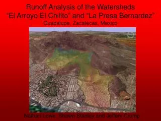
Runoff Analysis of the Watersheds “El Arroyo El Chilito” and “La Presa Bernardez” Guadalupe, Zacatecas, Mexico. Nathan Lowe, Shawn Stanley and Jeffery Crump. The Problem.

E N D
Runoff Analysis of the Watersheds“El Arroyo El Chilito” and “La Presa Bernardez” Guadalupe, Zacatecas, Mexico Nathan Lowe, Shawn Stanley and Jeffery Crump
The Problem • Between the city of Zacatecas and a nearby town called Guadalupe, a significant amount of urbanization is taking place, which is altering the runoff of two small watersheds, “Arroyo El Chilito” and “la Presa Bernardez”. • Due to the recent development, flooding has increased in frequency and magnitude. The pavement has caused the ground surface to become less permeable, so that precipitation accumulates on the surface rather than absorbing into the soil. • As urbanization continues, this hazard is expected to escalate, a concern to those who are aware of the problem.
Data Needed • Digital Elevation Model (DEM) • Land use distribution • Soil type distribution • Precipitation • Aerial photos and maps
Delineation of the Sub-basins • Import the DEM • Run TOPAZ (flow accumulation software) • Choose the outlet point for the basin • Run “Delineate Basins Wizard”
DEM Data • 30-meter resolution • UTM NAD 27 coordinate system • Digital basin delineation by flow accumulation La Presa Bernardez El Arroyo El Chilito
Land Use and Soil Type Data Land Use • Digital images from INEGI (National Institute of Statistics, Geography and Informatics) • Superposition of land use and soil type polygons • Association of permeability with polygons for infiltration calculations Soil Type
Precipitation Data • Intensity-Duration-Frequency (IDF) curves from historical data • Design storm: • SCS Type II 2- or 24-hour distribution
Projected Flows • By modeling a hypothetical expansion of urbanized areas, the average permeability of the watersheds further decreases. • An additional analysis in HEC-1 and HMS was performed to reflect this change. • Comparing the two scenarios, further development will increase peak flows by approximately 1.5 to 2 times the current flows.
HEC-HMS vs HEC-1 • Problems with computations • Differences in calculations
Recommendations • La Presa Bernardez • Reinstate the existing detention basin by controlling the outflow with an adjustable gate. • Determine the basin volume necessary to effectively delay and attenuate the peak flow through the outlet. • This will reduce the risk of flooding downstream for design storm events. • El Arroyo El Chilito • Clear the debris from the channel downstream of the highway. • Determine if the channel is capable of conveying design storm flows. • Use the abandoned area upstream of the highway as a retention basin.
Further Analysis Needed • HEC-RAS models of channels below outlets • Topographical surveys of detention basins above outlets • Basin outlet analyses to size detention basins based on headwater requirements
Questions? Special thanks to Dr. Jim aka “Mascarita Divina”