Download
1 / 17
170 likes | 258 Views
ETIS is a tool for estimating impervious surfaces' impact on water quality, comparing various data sources. It analyzes rooftops, roads, sidewalks, and more. Validation and calibration data guide its regression model for water quality impact assessment.

E N D
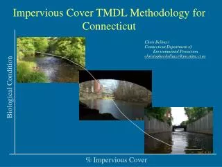
Estimation Tool for Impervious Surfaces (ETIS) Anna Chabaeva Jason Parent Daniel Civco Department of Natural Resources Management & Engineering The University of Connecticut U-4087, Room 308, 1376 Storrs Road Storrs, CT 06269-4087
Comparepredicted amount of imperviousness to: • highly accurate and precise planimetric data • NLCD 2001 impervious surface layer • CCL 2002 impervious surface layer • ISAT derived impervious surface data (NLCD, CCL) Objectives Describe functionality of newly developed ETIS tool
Rooftops Transportation System • Roads • Sidewalks • Driveways • Parking lots • Buildings • Pools • Patios Impervious Surface (IS) The imprint of land development on the landscape:
100 90 80 70 60 50 40 30 20 10 0 DEGRADED WATERSHED IMPERVIOUSNESS (%) IMPACTED PROTECTED Influence of Impervious Surfaces on Water Quality
Validation Data 82 CT tracts Calibration Data 221 NY tracts ETIS – Regression Model where - b1 is the IS-axis intercept - b2 is the coefficient for population density - biare those for percentage of land cover category area within the tract - PopDen is the Population density - %Ai are the percent of the land cover category area within the tract
IS for existing conditions IS for changing conditions ETIS Overview
ETIS Data RequirementsLand Cover GRID, IMG, TIFF
SHP ETIS Data RequirementsAnalysis Unit
People/sq mi ETIS Data RequirementsPopulation Density
Preloaded DBF ETIS Data RequirementsCoefficients
SHP ETIS Data RequirementsChange Layer
ETIS Web Site http://clear.uconn.edu/tools/geospatial/etis/index.html
ETIS Download http://clear.uconn.edu/tools/geospatial/etis/index.html
Estimation Tool for Impervious Surfaces (ETIS) Anna Chabaeva Jason Parent Daniel Civco Department of Natural Resources Management & Engineering The University of Connecticut U-4087, Room 308, 1376 Storrs Road Storrs, CT 06269-4087 anna.chabaeva@uconn.edu