African Domain Climate Modeling Project: Enhancing Land Use Sensitivity and Impact Assessment
120 likes | 238 Views
Work on land use sensitivity, impact assessment, and agriculture modeling in North, West, and South Africa. Engage with regional teams, focus on precipitation, water cycle, and energy balance. Collaborate on aerosol studies, contribute to IPCC AR4.

African Domain Climate Modeling Project: Enhancing Land Use Sensitivity and Impact Assessment
E N D
Presentation Transcript
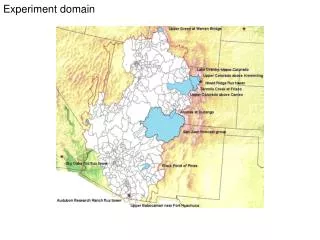
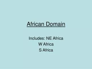
African Domain Includes: NE Africa W Africa S Africa
Motivation/Mid-term Goals • Land use change/sensitivity/agriculture: • Regional attribution • What’s expected in individual regions? • Forcings? • Land use impacts as part of climate change • Africanized model (includes baseline sim.) • Foci on precip, H2O cycle, surface energy balance, temp, crop model (Bill and Lisa for connections) • Engage with external forces/professionals • Engage aerosol studies. • Contribute to IPCC 4th Assessment Report.
African Networking • Domain sizes: • NE Africa (lat 40N 10S; lon 18E 60E; 100x88) • W Africa (lat 40N 5S; lon 25W 22E; 90x94) • S Africa (lat 5N 40S; lon 0E/W 57E; 90x114) • Team leaders: • NE: Hasanean M. • W: Ernest A. • S: Anne B. • Project ideas: • Mosaic of land use • Aerosols and convection (ICTP collaboration)
← Lat 40N 5S; Long 25W 22E African Domains ↑ Lat 40N 10S; Long 18E 60E ← Lat 5N 40S; Long 0E/W 57E
To do: • Center lines for domains. • Projection • Short runs to test/compare over domain, ~1997-2001 for: • NE: NDJFM • W: JJAS • S: DJF & JJA • Baseline simulation. • Literature review on land use, etc… in individual domains. • Land use variables: ppt, temp, runoff, clouds (1984-1989), convection, ITCZ.
Model parameters • Grell and Betts-Miller convection schemes • Use default baseline • .gif images to compare with similar intervals (posted on web) • Idea for live-access server betw groups (long-term)
Land use in NE Africa • Aerosols: linked to dust emissions; examine incoming tracers, using offline computations? • Reforestation experiments in Egypt; deforestation in Ethiopia – ppt, runoff, Nile river flow or not.
Land Use for W Africa • Lake Chad. • Nigeria: deforestation 2.8%/a; savanna movement; Sahel movement. • Investigate driving forces of above in W Africa: change forests to cropland to examine deforestation effects. • Aerosols: linked to fire/gas/dust emissions; examine incoming tracers, using offline computations?
Land Use for S Africa • Aerosols: linked to fire emissions; examine incoming tracers, using offline computations? • Literature review for further case studies.
Milestones • W Africa associates with ICTP and Jeremy • NE Africa assoc. Greg and Nellie • S Africa based in CT/Pta, SA • Due date for: • Short runs: Aug. 2003 • Long runs: mid 2004 • Perturbation runs: mid 2004-early 2005 • Need planning workshop (Egypt?) for: • Long runs • Logistics • Target date for workshop: early Nov 2003 in Egypt ! • Writing workshop 2005
Other Issues • Computing resources. • Visiting other institutions: • Computing • Writing (thinking time) • Data storage. • Etc…
Additional issues/needs • Resolution (high res. exp.) with Jeremy. • Emissions data (Fabien) • Add betts-miller scheme (Bi) • Computing needs (need computers for west africa runs) • Late 2003 meeting • Subgrid parameterization