Download
1 / 3
30 likes | 152 Views
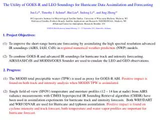
The Utility of GOES-R and LEO Soundings for Hurricane Data Assimilation and Forecasting Jun Li @ , Timothy J. Schmit # , Hui Liu & , Jinlong Li @ , and Jing Zheng @ @Cooperative Institute for Meteorological Satellite Studies, University of Wisconsin-Madison, Madison, WI

E N D
The Utility of GOES-R and LEO Soundings for Hurricane Data Assimilation and Forecasting Jun Li@, Timothy J. Schmit#, Hui Liu&, Jinlong Li@, and Jing Zheng@ @Cooperative Institute for Meteorological Satellite Studies, University of Wisconsin-Madison, Madison, WI #Advanced Satellite Products Branch, Satellite Applications and Research, NESDIS/NOAA, Madison, WI &National Center for Atmospheric Research, Boulder, CO GOES-R Risk Reduction Annual Meeting, 21 – 23 September 2011, Huntsville, Alabama 1. Project Objectives: To improve the short-range hurricane forecasting by assimilating the high spectral resolution advanced IR soundings (AIRS, IASI, CrIS) in regional numerical weather prediction (NWP) models. To combine GOES-R and advanced IR soundings for hurricane track and intensity forecasting. AIRS/IASI/CrIS and MODIS/GOES Sounder are used to emulate the LEO and GEO observations. 2. Progress: The MODIS total preciptable water (TPW) is used as proxy for GOES-R ABI. Positive impact is found on both track and intensity analysis when MODIS TPW is assimilated. Single field-of-view (SFOV) temperature and moisture profiles (12 ~ 14 km at nadir) from AIRS radiance measurements with CIMSS hyperspectral IR Sounding Retrieval algorithm (CHISR) have been used in assimilation experiments for hurricane track and intensity forecasts. Both WRF/DART and WRF/3DVAR are used for Hurricane and typhoon assimilation. Positive impact is found on cyclone intensity and track forecast, both temperature and water vapor profiles are important for hurricane forecast.
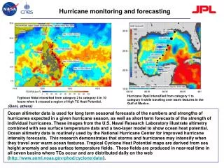
Terra MODIS TPW over ocean (10 September 2008) Aqua MODIS TPW over ocean (10 September 2008) AMSR-E TPW (10 September 2008) Control (CTL): Radiosondes, cloud winds (AMVs from JMA) extracted from NCEP/GFS dataset, aircraft data, station and ship surface pressure data, JTWC advisory TC positions, 6-hourly analysis cycle. TPW-IR:Add MODIS IR TPW data (both Terra and Aqua). TPW-IR-MW: Add MODIS and AMSR TPW data. Assimilations with WRF/DART started Sep. 1, 2008. WRF 9 km moving nest grid with feedback to 27 km grid in the forecasts. ABI water vapor product should be better than MODIS because: ABI has more water vapor absorption bands; MODIS TPW is from regression, ABI TPW is from physical retrieval; ABI has three layer precipitable water; ABI has high temporal resolution.
3. Future work: Assimilate the GOES Sounder high temporal resolution precipitable water (PW) between 300 and 700 hPa; Combined AIRS and MODIS/GOES Sounder for hurricane forecast in order to prepare the application of combined GOES-R/JPSS atmospheric profiles in high impact weather applications; Continue to collaborate with CIRA (Zupanski) on using GOES-R for hurricane (e.g., using SEVIRI/AIRS data). AIRS 700 hPa T (upper left); WRF 700 hPa T (lower left); Difference between AIRS and WRF AIRS run with WRF/3DVAR uses clear-skies from 3 granules g066/067/068, assimilate T/q profiles between 200 - 700hPa in the experiments for next 48 hour Hurricane Ike (2008) track forecast GTS: Conventional and other Sat data A1T27: GTS+AIRS 200 – 700 hPa T A1Q27: GTS+AIRS 200 – 700 hPa Q A1TQ27: GTS+AIRS 200 – 700 hPa TQ