Download
1 / 39
400 likes | 614 Views
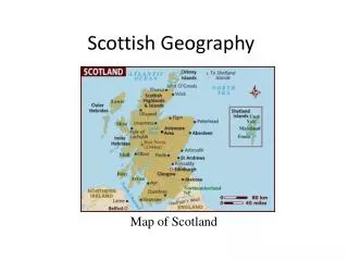
Scottish Geography. East Coast. Aberdeen St Andrews Dundee Perth Peterhead. Dundee . Viewed from Fife, the city of Dundee rises from the north shore of the River Tay. In the late 19th and early 20th century, Dundee was famed for it's textile industry- especially the production of jute.

E N D
East Coast • Aberdeen • St Andrews • Dundee • Perth • Peterhead
Dundee • Viewed from Fife, the city of Dundee rises from the north shore of the River Tay. • In the late 19th and early 20th century, Dundee was famed for it's textile industry- especially the production of jute. • It employed many women -challenging stereotypical gender roles of men being 'breadwinners' and women looking after the children.
Dundee After World War II the textile industry fell into steep decline due to cheap labour and therefore production costs in India. Since then a new industry has appeared. However, Dundee became a centre for game production in the 1980s and this has continued on with nearby university, The University of Abertay, offering the world's first course in computer gaming design.
Perth • Perthshire is one of the largest counties in Scotland. It has an excellent network of roads and railway which includes the main north/south railway line. • The southern parts of Perthshire are very low land, most of the land is farmland supporting both crops and pasture. • In the Eastern part of Perthshire lies the town of Perth on the River Tay. According to a 2008 estimate, it has a population of 44,820.
Peterhead Peterhead sits at the Easternmost point in mainland Scotland. It is often referred to as 'The Blue Toon' and people who were born there as 'Blue Tooners', supposedly from the blue stockings that the fishermen originally wore.
Peterhead • In 2006, the population was estimated at 17,330. Peterhead was founded by fishermen and was developed as a planned settlement. In 1593, the construction of Peterhead's first harbour, Port Henry, encouraged the growth of Peterhead as a fishing port and established a base for trade.
St Andrews • St Andrews was originally called Kilrymont. The earliest inhabitants of this area led a simple life and were mainly farmers and fishermen. The early inhabitants were concentrated around the harbour and cathedral area. • St Andrews grew into an important town in the middles ages. Four parallel streets were made: South street, Market street, North street, and Swallogait (now known as The Scores).
St Andrews • A city wall with gates was built, The West Port (Gate) is also now Scotland's best surviving example of a fortified gate. • St Andrews is now a main tourist attraction in Scotland as it is known as 'the home of golf' -the place where golf was invented.
Aberdeen • Aberdeen is situated on the North Sea coast, between the River Don, to the north, and the River Dee, to the south. • The geography of Aberdeen has greatly shaped it's history. In the 1970s the fate of Aberdeen was changed as oil was discovered just 100 miles off the coast of Aberdeen, in the North Sea.
Aberdeen • The discovery of oil greatly boosted the economy. During the boom of the 1970s, Aberdeen became the centre of the north sea oil industry and a major supply centre for North sea oil platforms. • The oil boom provided jobs and financed the construction of housing, offices and new schools throughout the city.
St Andrews s'est appelé Kilrymont et c'est le berceau du golf. • Il y a cent ans, l'industrie qui était le plus important à Dundee était les textiles. • Perth se trouve sur le banks de la fleuve Tay. • Peterhead s'appelle “The Blue Toon” • Dans la 1970s le pétrole était découvert a Aberdeen.
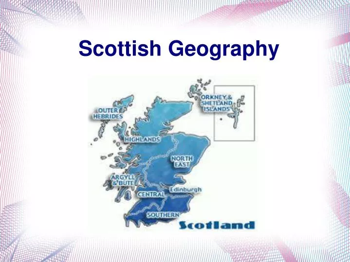
Islands • Outer Hebrides • Shetland • Orkney
Outer Hebrides The Outer Hebrides is a set of 119 officially named islands of which only 11 are inhabited for example Harris, Barra, and Eriskay. This gathering of islands is 209km in length with 97 named beaches. All of the islands within the Outer Hebrides are very flat the highest point in this group of islands is the Clisham 799m; this point is located on the Isle of Harris one of the 11 inhabited islands. These islands are separated from the mainland by 3 different bodies of water, The Minch, Little Minch and Sea of the Hebrides.
Shetland Shetland – Scotland’s northern most Island. It is made up of about 100 islands these islands are formed by ancient hills standing on the continental shelf 10 – 12,000 years ago at the end of the last glaciation these islands were partly drowned when sea levels rose 400ft. About 15 islands are inhabited leaving about 85 island to be solely inhabited by sheep, birds and seals. The highest point in Shetland is Ronas Hill 450m.
Orkney Orkney a set of about 100 islands of which 20 are inhabited with about 21,000 people, is located again in the north of Scotland and is only 11km away from the mainland at the narrowest point of the Pentland Firth. Most of the islands the are uninhabited may have 'Holm' in the name and if it has 'Papay' in its name it generally suggests that associated with early Celtic Christian missionaries.
Il n'y a que 11 îles qui sonthabité. • Les Hébrides extérieures sont séparées du continent par le minch peu et la mer des Hébrides • Le plus nord île en Écosse est l'île Shetland. • La population de l'île Orkney est 21,000 • Si unîle est inhabité il y aurait le mots 'Holm' dans son nom.
Le plus haut pic d’Inner Hébrides sont 992m. • En moyenne il pleut environs 1883mm par année. • En 1930 l'île de St Kilda était vidangé. • Mull était attaché à Greenland.
Loch Lomond and The Trossachs • Heart of the central belt. • Ben Lomond stands 974 metres above sea level. • Largest body of freshwater in Great Britain. • C'est le cœur de centre. • Ben Lomond est 974m haut. • C'est le plus grand lac de l'eaudouce.
Glasgow • Glasgow's transport network has to be able to support a population of 575,000. • There's a subway, two train stations, two airports and a large bus station. • Well connected city. • Il y a un métro, deux gares, deux aéroports et plein de buses. • Le transport doit soutenir une population de 575,000.
Glasgow's River • Third longest river in Scotland, • Home to the worlds last ocean going paddle steamer, built in 1947. • Fundamental for shipbuilding and trade. • Nécessaire pour commerce et construction navale. • C'est le troisième plus longue fleuve en Écosse.
Edimbourg a construit sur sept collines. • La population d'Edimbourg est 440,000 qui a besion plein de stationnement, il y a 20,000.