Download
1 / 23

E N D
1. ArcCatalog and Geodatabases Francisco Olivera, Ph.D., P.E.
Srikanth Koka
Department of Civil Engineering
Texas A&M University
2. ArcCatalog ArcCatalog is one of the three components of the ArcGIS software. The other two are ArcMap and ArcToolbox.
ArcCatalog has advanced capabilities for accessing, managing and previewing data.
3. View Types There are three different types of views for data display:
Contents
Preview
Metadata
5. Preview
6. Metadata
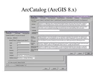
7. Geodatabase
8. Types of Geodatabases Personal Geodatabases:
Have .mdb extension.
Can be viewed by multiple users but edited by only one user at a time.
Have a maximum size of 2 Gigabytes.
Do not store raster data.
Multi-user Geodatabases:
Require ArcSDE and a DBMS ( Data Base Management Systems).
Can be read and edited by multiple users at the same time.
Can store raster data.
9. Personal Geodatabases Importable Data Types:
Coverages
Shapefiles
CAD drawings
INFO tables
DBF tables
Can be opened with ArcCatalog and MSAccess.
10. Geodatabase Elements
11. Feature Class A feature class is a collection of geographic objects in tabular format that have the same behavior and the same attributes. All feature classes have a field named �Shape.�
A feature class can be stored at the geodatabase root or in a feature dataset.
New feature classes can be created using ArcCatalog. To do this, right click on a geodatabase or feature dataset, and point to New/Feature Class.
12. Feature Class Types
13. Tables A table (or object class) is a collection of non-spatial objects in tabular format that have the same behavior and the same attributes. All object classes have a field called �ObjectID,� sometimes also called FID or OID.
Tables can be stored at the root level of geodatabases but not inside feature datasets.
Table format supported: INFO, dBase and others.
14. Attribute Domain Attribute domains are used to constrain the values allowed in any particular attribute of a table or feature class.
There are two different types of domains
Range Domains
Define a range of acceptable values for an attribute
Coded Value Domains
Define a set of acceptable values for an attribute
15. Domain Properties
16. Subtype
17. Feature Dataset
18. Feature Dataset Properties
19. Relationships A Relationship is an association or link between two objects in a database.
A relationship can exist between spatial objects (features of feature classes), non-spatial objects (records of tables), or between spatial and non-spatial objects.
20. Relationships
23. Relationship Class A relationship class is an association between two object classes (i.e., feature classes or tables).
Relationships can be one-to-one, one-to-many or many-to-many.
Can be created and edited using ArcInfo or ArcEditor only, but can be accessed with ArcView.
Can be inside or outside feature datasets.
24. References Mac Donald, �Building a Geodatabase�, Environmental Systems Research Institute (ESRI), Redlands, Calif
http://www.ce.utexas.edu/prof/maidment/giswr2003/visual/lecture22003.ppt
http://mark.gisc.kennesaw.edu/4405/Geodatabase.pdf
http://visc.sis.pitt.edu/resources/tutorials/GIS/Geodatabases.pdf
http://www.gis.state.ar.us/Downloads/GIS/presentations/Geodatabase%20101.pdf