Download
1 / 30
300 likes | 418 Views
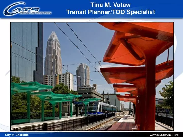
Tina M. Votaw Transit Planner/TOD Specialist. Milestones. 1998 2025 Integrated Transit/Land Use Plan developed based on Centers and Corridors Vision Led to voters approving transit sales tax 1999 Metropolitan Transit Commission established 2000 CATS created

E N D
Tina M. Votaw Transit Planner/TOD Specialist
Milestones 1998 2025 Integrated Transit/Land Use Plan developed based on Centers and Corridors Vision Led to voters approving transit sales tax 1999 Metropolitan Transit Commission established 2000 CATS created Light Rail LPA for South Corridor Major Investment Studies initiated in other corridors 2002 2025 Corridor System Plan adopted 2000-2006 Transit service expanded and improved 2006 2030 Corridor System Plan adopted 2007 LYNX Blue Line opened – ½ Tax Reaffirmed: 70%
Sales Tax Characteristics • 1/2 Cent County-Wide Tax • Generates $75 – $77 Million In FY09 • 66% Of Sales Tax Go To Bus Services • 30% Of Sales Tax Generated From Non-Mecklenburg Residents • Median-Income Family: approx: 13 cents daily • Does Not Include: grocery foods, automobiles, housing, medical visits and medicines, gasoline, insurance, utilities, debt, school, etc.
Operations • LYNX • Trains and systems continue to perform well • 0 preventable accidents • Permanent track repairs completed • Experimenting w/ 6 minute headways • Bus • Excellent accident record • Fall service change • Local and Express: up 14% • Circulators: up 32% • Regional Express: up 45% • Total: 80,000 – 90,000 trips per day • October 6 fare increase
Uptown to I-485: 9.6 miles • 15 stations (7 PNR’s, 3,100 spaces) • Trip estimates: • 2008 9,100/day • 2025 18,100/day
Transit Station Area Zoning • Three Base Transit Oriented Development Zoning Districts: • Residentially Oriented (TOD-R) • Employment Oriented (TOD-E) • Mixed-use Oriented (TOD-M) • Sample Characteristics: • Minimum densities of 20 DUA (1/4 mile) to 15 DUA (1/2 mile) • Minimum FAR of .75 (1/4 mile) and FAR of .50 (1/2 mile) • Maximum of 1.6 parking spaces per DU (residential) • Maximum of 1.0 parking space per 300 sq. ft. (office) • Maximum of 1.0 parking space per 250 sq. ft. (retail) • Minimum setback is 16 feet or as specified in Station Area Plan
Housing Policy for Transit Station Areas Principle Objective: Support the development of housing …affordable to a broad cross-section of the workforce…provide a variety of housing choices near transit stations. Policy Highlights: • Inclusion of affordable housing w/in transit station areas, especially when the City is participating in the project • Policy calls for 5%-25% of units of any multi-family development targeted for households earning 60% of AMI or less • At least 30% of those for households earning 30% or AMI or less • Shall be similar in appearance to market rate housing and scattered throughout the development
Sidewalks 14 miles Multi-use Trail 1.5 miles Bicycle Lanes 10 miles Street Widening 8 miles Streetscape Imp. 7 loc. Intersection Imp. 27 loc.
Crescent Resources Under Construction Bland Street Station
Morehead Square • Mixed use - project cost $36M • 296,000 sq. ft. office; 886 space parking deck • 40 condominiums • Immediately adjacent to Rail Corridor/Trolley line
Summit Grandview • 266 residential units • Approx. 70,000 SF office and retail • 465 parking spaces • $70 million project cost
Village of South End • Mixed use – 113 Residential Units • 23,000 sq. ft. office/retail
Scaleybark TOD/PPP South Blvd. CATS Park & Ride Dewitt St. Freeland Rd.
What Is the Project Vision? What Are The Expectations? Maximize Fair Market Value (FMV) of Land Achieve Mixed Use Development Meet Regulatory Requirements: FTA = Joint Development + State & Local Meet Technical Requirements: Consistency w/TOD & Design Principles Functional & Aesthetic Integration of Transit Imp. Achieve Public Policy Goals: Open Space Affordable Housing Remove Blight or Non Transit Supportive Uses Public Infrastructure Replacement Parking Ratio Can These Be Prioritized?
Economic Link • Privately funded. No federal funding in design or construction of the TOD improvements. • Will include commercial and residential land uses and transit parking. • Public Transportation Benefit • Adjacent to Station, encourages additional ridership, establishes station area identity and enhances mobility . Revenue for Public Transportation • Fair return for transfer of federally-assisted parcel , including construction of transit improvements by developer and permanent easement (i.e. continuing control ). Developer Build-Out
Lessons Learned • Determine each party’s goals and requirements up-front • Identify desired land uses, development standards and expectations • Recognize that if some of the desired components are not market-driven (e.g. open space, public facilities), there will likely be a trade off • If there is no expected appetite to fund a gap (i.e. the “ask”), be clear about that up front or how that may be addressed • PPP’s are a process, not a project
Projects In Development: SprinterStreetcar LineLYNX Purple LineLYNX Blue Line ExtensionLYNX Silver Line
Sprinter West Corridor Enhanced Bus • Implement Enhanced Bus Service In Two Phases • Phase 1: Center City to Wilkinson Boulevard to the Airport by 2009 • Phase 2: Freedom Drive by 2012 and West Boulevard by 2014 • 8 Miles – 5 Vehicles • 18 Stops • 15 outside of Uptown • 3 in Uptown • Projected Start Date: Summer 2009
Charlotte Streetcar • 10 Miles From Rosa Parks Place To Eastland Mall • 34 stops • Frequency • Peak: 7.5-10 minutes • Off peak: 15 minutes • Economic Development Study • Measure incremental impact of project • Projected completion: December 2008 • Cost • Refining 2006 cost estimate • Projected completion: December 2008
LYNX Purple Line • 25 Miles from Charlotte Gateway Station to Mount Mourne • Existing Norfolk Southern Railroad right-of-way • 10 Stations • Service • 22-40 trains daily • Peak: 20-30 minutes • Off peak: hourly • Spring 2009: Complete PE
LYNX Blue Line Extension • 11 Miles from Uptown to I-485 at North Tryon Street • 14 Stations • Supports development in NoDa and along North Tryon Street • 1 - 2 Stations at UNCC • Spring 2009: 15% design and cost estimate
LYNX Silver Line • 13.5 Mile Bus Rapid Transit (BRT) Line • 16 Stations; 7 park and ride lots • Anticipated Daily Ridership: (2030): 15,500 • Special Provisions: • BRT implementation delayed 5 years to revisit LRT option • Complete environmental work to advance NCDOT highway project • Extend busway and preserve ROW for BRT or LRT
Next Steps - 2030 Plan • South Corridor • Open for Service • Northeast Corridor • Preliminary Engineering • North Corridor • Preliminary Engineering • Streetcar Corridor • Advance after Northeast and North (2018/2023) • Southeast Corridor • Technology decision in 2011 • Completed 2022-26 • West Corridor • Enhanced bus service 2009 • Convert to streetcar by 2029 - 2034 Approved November 15, 2006