Download

1 / 9
90 likes | 171 Views
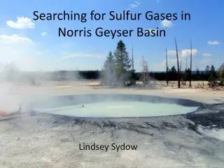
Dive into the search for sulfur gases in Norris Geyser Basin using ArcGIS Online and USGS resources. Learn data manipulation techniques to pinpoint water features with specific chemical properties near Cinder Pool.

E N D
Searching for Sulfur Gases in Norris Geyser Basin Lindsey Sydow
Searching ArcGIS online • Somewhat of a failure • Not enough detail for my purposes • Thermal features: too few • Geological maps: too great of scope
Searching USGS.gov National Geologic Map Database Tells you which results have GIS data!
Manipulating Data • Need to adjust points (flowing springs) and polygons (pools or springs) to be a single layer: “water_features” • “Select by attributes” to separate springs from vents and other non-water point features (New layer: Springs) • “Feature to Point” to turn pools into points (New layer: basin_centroids) • “Merge” to join the two new layers into one: water_features.
Acquired Chemical Data from PDFs(Yes, that is as bad as it sounds) How I acquired my pH data What will be added
Major factors for identifying features of interest • Water temperature 85-110oC • pH between 3 and 4.5 • Not necessarily requirements • Geology—fluvial deposits • Proximity to Cinder Pool • In Cinder Pool: • Temperature is ~90oC at the surface, but 113oC at the bottom • pH is ~4
Still to be dealt with: projection issues • “events” layer • “UTM” layer
What remains? • EITHER joining my point shapefiles OR projecting these same features from the USGS chemical data—rest of data is already ready to go • Using previously mentioned criteria to select by attributes the best features to sample during next Yellowstone trip.