Download
1 / 17
180 likes | 276 Views
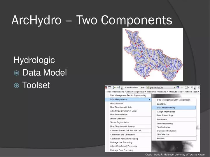
ArcHydro – Two Components. Hydrologic Data Model Toolset. Credit – David R. Maidment University of Texas at Austin. ArcHydro – Data Model. Based on inventory of all features for an area Behavioral model – trace direction of water movement across landscape. Network. Drainage.

E N D
ArcHydro – Two Components Hydrologic • Data Model • Toolset • Credit – David R. Maidment University of Texas at Austin
ArcHydro – Data Model • Based on inventory of all features for an area • Behavioral model – trace direction of water movement across landscape Network Drainage HydroFeatures Hydrography Channel • Credit – David R. Maidment University of Texas at Austin
ArcHydro – Data Model • Developed with National Hydrogrophy Dataset (NHD) in mind • Tools intended to be used with NHD • Integrated raster-vector database • Credit – David R. Maidment University of Texas at Austin
ArcHydro - Tools • Set of tools used to derive end-products • Flow network • Hydrologically conditioned DEM • Iterative, step-by-step approach with required inputs • Raster several formats, vector utilizes geodatabase only
ArcHydro - Tools • Set of tools used to achieve end-products • Flow network • Hydrologically conditioned DEM • Catchment delineation • Iterative, step-by-step approach with required inputs • Raster several formats, vector utilizes geodatabase only • Credit – David R. Maidment University of Texas at Austin
ArcHydro • Cons • Semi-automated • Install can be difficult • User interpretation and editing introduces subjectivity • Need to know what default settings mean • Few training resources • Pros • Semi-automated derivation of key products • Semi-supported • Free • Integrates data from multiple sources and of different types
Hydrologic Modeling • Predict response of hydrologic systems to changing variables, i.e. precipitation • Process-based - try to represent the physical processes observed in the real world • Dozens available – TOPMODEL, SWAT, HSPF, etc. • Variables - Surface runoff, evapotranspiration, etc. • Increasing GIS integration • Credit – Pajaro Valley Water Management Agency
Hydrologic Modeling - Hydraulics • Model hydraulics of water flow over land and through channels • Assess peak discharge, volume estimates, runoff curve numbers, etc. • HEC-RAS • Increasingly GIS-based or integrated
Erosion Analyses • Locate sites of likely gully and other streambank interface erosion • Terrain Analysis approach – Stream Power Index (SPI) • High SPI values indicate high potential overland flow • Quantitative, spatial, repeatable
Water Storage • Utilize LiDAR to accurately identify size, depth, and location of depressions in the landscape • Reduce Peak Flows • Reduce sediment and nutrients transported downstream
Water Storage • NRCS will have tools available in the future to better calculate • Rough calculation • Perform Pit-fill • Subtract original DEM from pit-filled DEM to locate larger depressions • Multiple methods for determining volume
Floodplain Mapping/Delineation • National Flood Insurance Program • Local communities regulatedevelopment in floodplains • Requires accurate floodplain maps • 100 Year Flood boundary • Keep building out of 100 year inundation area
Floodplain Mapping/Delineation • Administered by FEMA • Utilizes Flood Insurance Rate Map (FIRM) • Update process to digital (DFIRM) • Credit – FEMA
Flood Inundation Area Mapping • Mimic flooding at various stages to determine land area and locations inundated • Needs • Highly accurate land elevation data – LiDARDEM • Modeling Capabilities- Hydraulic Engineering Center–River Analysis System (HEC–RAS) • Stream-gauge heights/peak-flow readings
Flood Inundation Area Mapping LiDAR DEM Stream gauge Data Model (HEC-RAS) Hydrologic Conditioning Calibration Inundation Area Map Conditioned DEM Flood Surface Elevations • Credit – USGS
Flood Inundation Area Mapping Hydrologic Conditioning - Key • Credit – USGS


![G6 - CIRCUIT COMPONENTS [3 exam question - 3 groups]](https://cdn1.slideserve.com/2780393/g6-circuit-components-3-exam-question-3-groups-dt.jpg)