Astoria Bridge Vista Code Amendments Process Overview
180 likes | 201 Views
Reviewing key issues & options for Astoria's Bridge Vista Area land use objectives. Discussing zoning, design, and access to water with community guidance.

Astoria Bridge Vista Code Amendments Process Overview
E N D
Presentation Transcript
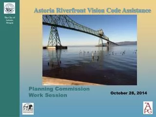
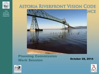
Planning Commission Work Session October 28, 2014
Work Session Objectives • Provide overview of Bridge Vista code amendments process, issues • Discuss first set of key issues and options • Obtain comments and guidance on preferred options or approaches • Review next steps
Bridge Vista Area - Land Use Objectives • Continue to support water-dependent uses; allow for commercial and residential uses that support but don’t compete with the Downtown core. • If development is to occur, promote new uses that are consistent with Astoria’s “working waterfront.” • Encourage design of new or rehabilitated buildings that respect Astoria’s character. • Encourage new development along the River to improve and celebrate the River Trail and provide visual and periodic physical access to the water.
Bridge Vista Area - Land Use Objectives • Improve physical connections to adjacent neighborhoods. • Use setbacks, stepbacks and other measures to ensure an open feel and continued visual access to the river. • Change zoning of area west of 2nd Street from Tourist Commercial to other commercial zone. • Expand (Uniontown) design overlay for the historic district to accentuate the historic area (north of US 30) and create a more prominent gateway for the urban core.
Bridge Vista Land Use Code Issues • Comprehensive Plan policies • Overwater development standards • Physical access to the water • On-land building height, set-backs and step-backs • Permitted uses (on land and over water) • Complementing downtown development • Tourist Commercial zone update • Design standards and guidelines • Landscaping
Bridge Vista Land Use Code Issues - Tonight • Comprehensive Plan policies • Overwater development standards • Physical access to the water • On-land building height, set-backs and step-backs
Comprehensive Plan Policies • Note importance of River vistas • Emphasize uses that complement Downtown • Incorporate references to Riverfront Vision Plan
Overwater Development Approach • Height restrictions to protect key vistas – bridge and area near 2nd Street • Allow overwater development in most other areas • Limit building widths; provide view corridors (prevent a wall of buildings)
Building heights • Within exception areas: Top of bank • Outside exception areas: 35 feet
Building width limitations • Building size limitation: Maximum building width of 150 square feet • Total width of all buildings: Maximum total width (all structures) 60% of contiguous parcel width • View corridors between buildings: 40 feet
River Access Requirements – Similar to Civic Greenway • Three options – required for new uses • Access hours to be determined by parks, police • Walkways, piers 10-14 feet wide, extending beyond structure to allow views up/down river
Building Height, Setbacks and Stepbacks (land zones) • Maximum Height: Base height of 35 feet; heights can be increased to 45 feet if additional setback or stepbacks above 24’ • Setback: • Maintain 70’ view corridor on north/south streets • 10’ setback S. of trail; 20’ N. of trail • Stepback: Required 10’ stepback above 24 feet
Next Steps • Update code amendments based on Work Session guidance. • Work on next set of draft code amendments: • Permitted uses [November] • Modification of C-2 (Tourist Commercial) zone [November] • Design guidelines and standards [December] • Landscaping [December] • Provide draft materials in advance of November work session. • Conduct work session in November • Conduct work session on December