Download
1 / 14
140 likes | 168 Views
Explore the potential impact of granting free open access to RapidEye satellite imagery, supporting various applications from agriculture to disaster response, with the opportunity to acquire assets at a substantial discount. Proposal suggests a model for sustainable continuation of RapidEye operations under donor financing. Learn about Landsat history, operational requirements, and the future of land remote sensing observations.

E N D
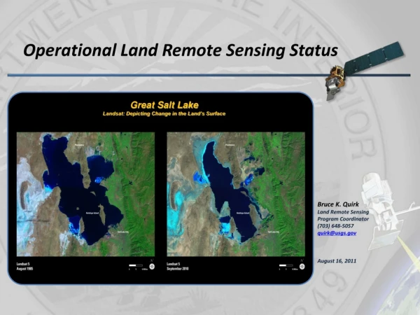
Operational Land Remote Sensing Status Great Salt Lake Landsat: Depicting Change in the Land’s Surface Bruce K. Quirk Land Remote Sensing Program Coordinator (703) 648-5057 quirk@usgs.gov August 16, 2011
NORTH AMERICA | Acquisition Frequency in 2010. Source: USDA Briefing
Executive Summary • RapidEye’s bankruptcy could advance global sustainable development if we succeed in making its satellite imagery freely available to the public. Free imagery would catalyze innovation and advance US goals in food security and global change • RapidEye imagery fills an important gap - open access would catalyze innovation • Imagery supports agricultural development, disaster planning/rapid response, land use planning, ecosystem markets • Users need regular, repeated observations at sub-10m resolution in spectral frequencies that discriminate between land uses. Can leverage expertise from coarser Landsat and MODIS technologies • RE provides 4 million km2 in daily imaging capacity at 6.5m resolution in 5 spectral bands: NIR, Red, 3 visible bands. Data catalog from 2009, expected life through 2018 • Open access to data would advance research in known fields and catalyze innovation in new areas (just as sharing Landsat and GPS information did) • Receivership means an opportunity to acquire assets at reasonable cost. • Filed for bankruptcy protection in June 2011. Restructuring will conclude Sept 2011 • Capital structure:$114m in debt; 80% guaranteed by the German government. Creditors are KfW, Commerzbank and Canada’s Export Development Corporation. Creditors willing to renegotiate debt • Operating Expenses estimated at~$18.5m per annum • Bottom line: opportunity to secure RapidEye’s operating assets at substantial discount – no launch risk Source: USDA Briefing * At an exchange rate of €1=$1.42, sourced at xe.com on 14 July 2011
Executive Summary • Proposal: RapidEyeas a global public good sponsored by the USG • Proposed model: free, open access to RE imagery under Landsat-style IP rules, Operating Expenses supported by donor financing (~$14m per annum) and sale of value-added services ($5-7m p.a.) through 2018 • Governed by donor-led international advisory committee that would appoint management to oversee operations • Management team could be hosted within a multilateral organization (e.g. Consultative Group on International Agricultural Research (CGIAR)), a U.S. institution (e.g. the Smithsonian) or a German non-profit organization • At minimum, bidders have to cover operating cost through 2018 (~$130m). Capital Expenditure will also be required if existing creditors and guarantors are unwilling to write off investment Source: USDA Briefing
Landsat 9 and Beyond • USGS has served as the Landsat data steward since program’s inception in 1966 • experienced several changes in program leadership, including two unsuccessful attempts to commercialize the satellites • USGS Joined NASA in 2000 as full partner in program management • Presidential Decision Directive NSTC-3 (5/94, revised 10/00) • NASA and USGS funded for Landsat 8 development; funding projected for USGS operations through 2017 • National Space Policy – June 28, 2010 Land Remote Sensing The Secretary of the Interior, through the Director of the United States Geological Survey (USGS), shall: • Conduct research on natural and human-induced changes to Earth’s land, land cover, and inland surface waters, and manage a global land surface data national archive and its distribution; • Determine the operational requirements for collection, processing, archiving, and distribution of land surface data to the United States Government and other users; and • Be responsible, in coordination with the Secretary of Defense, the Secretary of Homeland Security, and the Director of National Intelligence, for providing remote sensing information related to the environment and disasters that is acquired from national security space systems to other civil government agencies. In support of these critical needs, the Secretary of the Interior, through the Director of the USGS, and the NASA Administrator shall work together in maintaining a program for operational land remote sensing observations • President’s FY 2012 Budget requested $48 million to start operational land imaging program (Landsat 9 and 10) 7
Landsat 9 Assumptions • Maintain Data Continuity • Landsat 5 will exhaust its fuel by December 2013 • Landsat 7 will exhaust its fuel by January 2017 • Landsat 8 with a December 2012 launch and five-year design life puts end of life (EOL) at Spring 2018 and with 10 years of fuel by Spring 2023 • Thermal Infrared Sensor (TIRS) design life is three years – EOL Spring 2016 • Minimize Program Risk • Ensure success of mission • Minimize technical and schedule risk for Landsat 9 • Achieve mission goals within budget profile • Improve upon Landsat 8 performance • Thermal enhancements include increasing instrument design life from 3 to 5 years • Spacecraft improvements (e.g. >400 scenes per day acquired) • Landsat Science Team trade study input 8
USGS/NASA Interactions • Monthly meetings with Headquarters and Centers • Developing Landsat documentation • Agreements – umbrella and annexes • Documents • Level 1s, etc. • Acquisition Strategy Meeting • Trade studies • TIRS • Budget scenarios FY 2012 to FY 2027 9
FY 2012 House Report • House Report • “In addition, the USGS has proposed a new account for the National Land Imaging Program, which includes the development of the Landsat satellite program. For FY2012, the House Appropriations Committee expressed its approval of the budget realignment, yet rejected the creation of the National Land Imaging Program as a new account.” • “The increase over the request reflected the inclusion of some funding that was requested for the National Land Imaging account, which was not funded by the committee. Additional funding over the request was expected to support the LandSat program beyond LandSat 8. The committee also urged the Administration to submit a FY2013 request that does not offset increases for LandSat with decreases elsewhere in the USGS budget.” • National Land Imaging “The House Appropriations Committee did not support the Administration’s proposal to consolidate responsibilities for the Landsat program within the USGS. Currently, responsibilities are shared between the National Aeronautics and Space Administration (NASA) and the USGS. The committee rejected the proposal in part on the grounds that there was no corresponding proposed transfer of funding from NASA and program costs are expected to increase substantially in the next couple of years.” 10
FY 2012 House Report (cont) • USGS Amendment to House Interior Appropriations Bill“Yesterday, Representative Rush Holt (D-NJ) introduced an amendment to HR 2584, the FY 2012 Interior and Environment Appropriations Bill, which is currently being considered on the floor of the House. The amendment would increase funding for USGS Surveys, Investigations, and Research by $13.929 million.AMENDMENT NO. 68: At the end of the bill (before the short title), insert the following: __. The amounts otherwise provided by this Act are revised by reducing the amount made available for "BUREAU OF LAND MANAGEMENT-MANAGEMENT OF LANDS AND RESOURCES'', and increasing the amount made available for "UNITED STATES GEOLOGICAL SURVEY-SURVEYS, INVESTIGATIONS, AND RESEARCH'', by $15,929,000 and $13,929,000, respectively. According to staff in Mr. Holt's personal office, the amendment aims to restore some of the cuts the bill would make to USGS climate research and data analysis for Landsat 8. If Rep. Holt is going to offer the amendment on the floor, he will likely do so when the chamber reaches the end of the bill; floor consideration of amendments are proceeding page by page.On Monday, Rep. Holt spoke on the House floor about HR 2584. Regarding the USGS, he said: "This bill includes reductions in funding for the U.S. Geological Survey, research in climate and land use, scientific research, monitoring, modeling, forecasting. Let me give an example: The LandSat 7 satellite just in the past month has been used to track the largest fire in Arizona’s history. Yet because of the cuts that would come to pass through this legislation, the data coming from the LandSat system would go unrecorded, unanalyzed, unused. Talk about false economy." [Source: Congressional Record, July 26, 2011, page H5453]” 11
FY 2012 House Report (cont) STATEMENT OF ADMINISTRATION POLICY - H.R. 2584 — Department of the Interior, Environment, and Related Agencies Appropriations Act, 2012 “The Administration strongly opposes a number of provisions in this bill, including ideological and political provisions that are beyond the scope of funding legislation. If the President is presented with a bill that undermines ongoing conservation, public health, and environmental protection efforts through funding limits or restrictions, his senior advisors would recommend he veto the bill. While overall funding limits and subsequent allocations remain unclear pending the outcome of ongoing bipartisan, bicameral discussions between the Administration and congressional leadership on the Nation's long-term fiscal picture, the Administration has concerns regarding the level of resources the bill would provide for a number of programs in a way that undermines core government functions, investments key to economic growth and job creation, as well as protection of public health and the environment and preservation of our Nation's natural resource heritage, including, but not limited to: Department of the Interior (DOI) * * * * Landsat. The bill does not provide funding to begin the acquisition of the next Landsat satellite, ending a 40-year stream of data that is used by Federal, State, local and Tribal governments and the private sector to make informed land and resource management decisions and to assess the impacts of those decisions over time.” 12
Landsat Science Team • Logistics • Direct questions, comments, etc. to me (quirk@usgs.gov) • We have ~8 months • Support requirements process • Identify who would be involved from professional societies, contacts • Comment on database schema • Letters to editors, op-ed pieces, etc. • Identify stakeholders (individuals & organizations) • Identify/produce products • What is it/why now • Importance of open archive/what is value of Landsat 13
Questions? Landsat 7: Lena DeltaImage taken 7/27/2000 The Lena River, some 2,800 miles (4,400 km) long, is one of the largest rivers in the world. The Lena Delta Reserve is the most extensive protected wilderness area in Russia. It is an important refuge and breeding grounds for many species of Siberian wildlife. 14