Download
1 / 11
110 likes | 215 Views
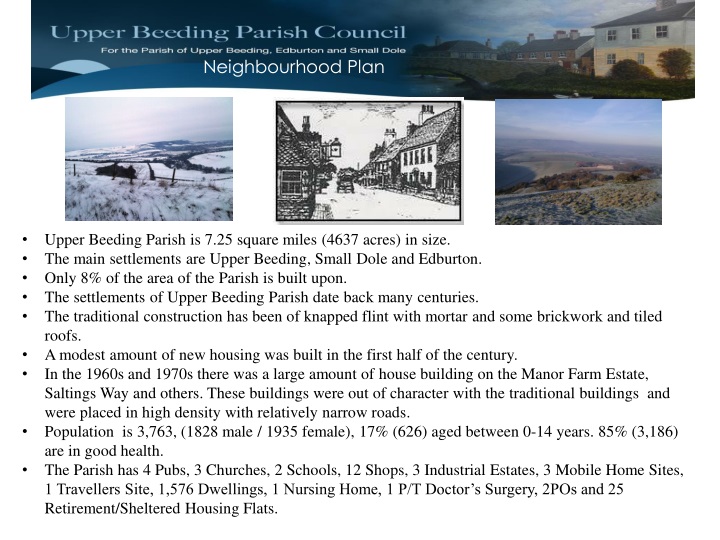
Neighbourhood Plan. Upper Beeding Parish is 7.25 square miles (4637 acres) in size. The main settlements are Upper Beeding, Small Dole and Edburton. Only 8% of the area of the Parish is built upon. The settlements of Upper Beeding Parish date back many centuries.

E N D
Neighbourhood Plan • Upper Beeding Parish is 7.25 square miles (4637 acres) in size. • The main settlements are Upper Beeding, Small Dole and Edburton. • Only 8% of the area of the Parish is built upon. • The settlements of Upper Beeding Parish date back many centuries. • The traditional construction has been of knapped flint with mortar and some brickwork and tiled roofs. • A modest amount of new housing was built in the first half of the century. • In the 1960s and 1970s there was a large amount of house building on the Manor Farm Estate, Saltings Way and others. These buildings were out of character with the traditional buildings and were placed in high density with relatively narrow roads. • Population is 3,763, (1828 male / 1935 female), 17% (626) aged between 0-14 years. 85% (3,186) are in good health. • The Parish has 4 Pubs, 3 Churches, 2 Schools, 12 Shops, 3 Industrial Estates, 3 Mobile Home Sites, 1 Travellers Site, 1,576 Dwellings, 1 Nursing Home, 1 P/T Doctor’s Surgery, 2POs and 25 Retirement/Sheltered Housing Flats.
Neighbourhood Plan • Housing & Development Objectives • To Support the Parish with regards to Housing & Development needs over the next 20 years • To Seek to work with landowners to agree areas where housing could be provided to meet the needs and agreement of the Parish • To Look at what additional utility infrastructure improvements and support services would be required • To Produce a programme of planned and controlled house building to provide integrated and sympathetic growth
Neighbourhood Plan Age Spread Comparison 2001 to 2011 Census
Neighbourhood Plan 1,988 People in UB Parish Aged Between 16 – 74 & their Occupations
Neighbourhood Plan Housing Spread over the Parish 2001 -2011
Neighbourhood Plan • Key Observations from 2011 Census • The Parish has an ageing population and may be attracting 65 years + • 65- 74 year olds have increased since 2001 • Only one Retirement Home (under construction ) and 1 Nursing Home in the Parish. • If the current teenage population want to stay in the Parish in the next 10 years, we will not have enough accommodation to support them • Car ownership has increased and any new housing proposals have to accommodate adequate car parking spaces to the proportions of the property. • Nearly half of those working (2806), travel to work by car/van. • Rental accommodation has increased. Is this because housing is not affordable? • There are 161 dwellings which are classed as a second home. • Less people in the Parish since 2001. • Could some elderly release stock/their houses for small families or others to use • Car levels per household of 4 or more cars have vastly increased. (87) • Combination of young & old over next 20 years indicates a housing shortage to come • Decline of 30 - 44 year olds compared to 2001. • Properties overall have increased in the Villages over last 10 years
Neighbourhood Plan WHAT OUR YOUTH THINK / WANT
Neighbourhood Plan Feedback on Output from Quetionaire (10% Sample of the Parish) • 335 responses, 281 from UB, 51 from Small Dole and 3 from Edburton. (10%). • 44% responses from over 65s • 89% were Satisfied with the Local Area as a Place to Live (1.5% weren’t) • 98% feel safe at home and walking the streets • 43% said not enough local employment opportunities • 21% often use public transport 51% use it occasionally • 33% were satisfied with public transport • 33% said there was not enough Housing in the Parish • 32% said there was a need for Affordable Housing • 19% said there was a need for Family Housing • 13% said there was a need for Housing for Young People • 12% said there was a need for Housing for Older People • 48% said they did not make use of the Recreation Facilities in the Parish • Responses to what most needed improving were: • 73% Cement Works • 47% Traffic Speed • 37% Activities for Teenagers • 26% Public Transport • 26% Affordable Housing
Neighbourhood Plan • Housing Statistics • Comparison of 2001 and 2011 Census Data for the Parish of Upper Beeding, Small Dole and Edburton. • 3,763 people in the Parish – 39 less than 2001 • 1,627 dwellings (including mobile homes) in the Parish – 50 more than 2001 • Rented homes – private/council/housing association – 112 more than 2001 • 2806 residents are aged 16 – 74 years • 30 – 44 years old are 208 less than in 2001 • 16 – 17 year olds are 53 more than in 2001 • 65 – 74 year olds are 134 more than in 2001 • Over 90 year olds is the same as 2001 – 2011 • Only one Retirement/Sheltered Home (2015) – 25 Flats • Households with dependent children 460 – 16 less than 2001 • 2806 working – 1413 travel by car/van. 2636 own a car in the Parish • Houses with 4 or more cars has doubled since 2001. (87) • 90 households are considered overcrowded based on people to rooms – increase of 14 on 2001 data.