Download
1 / 84
880 likes | 1.35k Views
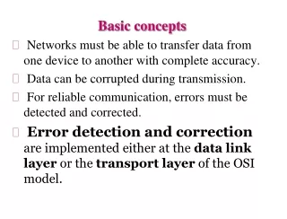
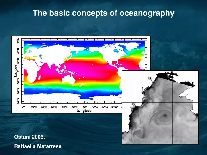
The basic concepts of oceanography. Ostuni 2006, Raffaella Matarrese. Oceanography is a multi-discipline science studying the World ocean. It includes: Physical oceanography Marine geology Marine chemistry Marine biology Marine technology etc.

E N D
The basic concepts of oceanography Ostuni 2006, Raffaella Matarrese
Oceanography is a multi-discipline science studying the World ocean. • It includes: • Physical oceanography • Marine geology • Marine chemistry • Marine biology • Marine technology • etc. WHY ARE OCEANS AND SEAS SO IMPORTANT? • Oceans as source of food, and energy • Oceans as transportation way • Oceans as ‘ideal’ place where to dump urban and industrial waste • Ocean plays an important role in the global weather and climate
Oceanographic applications of satellite remote sensing include: 1. Visible wavelength "ocean color" sensors 2. Sea surface temperature from infrared scanning radiometers 3. Passive microwave radiometers 4. Satellite altimetry of sea surface topography 5. Active microwave sensing of sea-surface roughness
Visible wavelength "ocean color" sensors These sensors operate in the visible part of the electromagnetic spectrum, measuring electromagnetic radiation emitted by the sun and reflected by land and ocean surface.
Visible wavelength "ocean color" sensors The color of the Earth’ surface, especially the color of the ocean, results primarily from biological processes. Measuring the absorption and backscattering characteristics of ocean surface, we can estimate the concentrations of different kinds of matter suspended in seawater, including phytoplankton cells.
Patterns of phytoplankton distribution in World Ocean obtained from ocean color CZCS, SeaWiFS and MODIS data revealed general pattern of phytoplankton biomass distribution in the World Ocean.
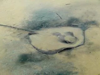
One of the basic topic of physical oceanography is ocean circulation. This image of MODIS satellite illustrates a plume of polluted water discharged after rainstorm from the mouth of Santa Clara River and transported by coastal current to Santa Monica Bay.
Sea surface temperature from infrared radiometers Infrared sensors measure electromagnetic radiation within the band 1-30 µm, emitted by the ocean surface and resulting from the temperature of the upper sea layer.
Sea surface temperature from infrared radiometers The near-infrared and infrared radiation is processed to sea surface temperature (SST). The most important SST sensors are Advanced Very High Resolution Radiometer (AVHRR) on NOAA satellites, MODIS, GOES geostationary satellites, and some others.
Active microwave sensing of sea-surface roughness Synthetic Aperture Radar (SAR) SAR images enable the analysis of small-scale and mesoscale eddies, river plumes, oil slicks, ice packs, etc.
SEA SURFACE TEMPERATURE AVHRR observations of sea surface temperature (SST) are very important for oceanographers, because they enable the analysis of spatial and temporal variations of ocean currents. At this image you see the Gulf Stream Current in North Atlantic.
Sea surface temperature from infrared radiometers The atmosphere is most transparent to infrared at 3.5-4.1 μm and 10.0-12.5 μm. At 10 μm, solar emittance is about 300 times the sea emittance. However, as a result of the distance between the sun and the earth, the solar irradiance reaching the top of the atmosphere is about 10-5 of its value near the solar surface, that is about 1/300 of the sea surface emittance. At 3.7 μm, the incoming solar irradiance is the same order as the surface emittance. As a result, this wavelength can be used during nighttime only. Emittance is radiant flux radiated from a surface per unit area, and expressed in a unit of Wm-2
Sea surface temperature from infrared radiometers Interpretation of Sea Surface Temperature • The actual thickness of the layer whose temperature is remotely sensed varies between 3 and 14 m. • It is called skin SST. It is the temperature of the first few mm of water. • At the same time, the measured in situ SST (called also bulk SST) corresponds to at least a few centimeters or more, depending on ocean roughness. The SST measurements on buoys may be anything between 0.5 and 3 m deep. • Three physical effects may increase the difference between skin and bulk SSTs: • Diurnal thermocline; • Thermal skin layer effect; • 3) The presence of surface film.
Time evolution of near-surface thermal gradients SkinDeEP profiles on 12 October 1999.Off Baja California, R/V Melville. From Ward, B. and P. J. Minnett, 2001. An autonomous profiler for near surface temperature measurements. Gas Transfer at Water Surfaces. M. A. Donelan, W.M. Drennan, E.S. Saltzmann and R. Wanninkhof (Eds.) American Geophysical Union Monograph 127. 167 - 172.
Sea surface temperature from infrared radiometers Atmospheric correction is based on multispectral approach, when the differences between brightness temperatures measured at different wavelengths are used to estimate the contribution of the atmosphere to the signal (more detail later, in AVHRR section). The idea of the first step of atmospheric correction in Multi-Channel Sea Surface Temperature (MCSST) algorithm is that the contribution of the atmosphere water vapor to the signal is different at different channels. We assume that the temperature deficit in one channel, which results from atmospheric absorption by water vapor, is a linear function of the brightness temperature difference of the two different channels. SST = A + B * (T1 – T2) + T1.
Sea surface temperature from infrared radiometers During daytime observations the channels 11 and 12 µm are used: SST = 1.0346 * T11 + 2.5779 * (T11-T12) - 283.21; During nighttime we can also use the channel 3.7 µm, which during daytime is contaminated with sunlight: SST1 = 1.5018 * T3.7 - 0.4930 * T11 - 273.34; SST2 = 3.6139 * T11 - 2.5789 * T12 - 283.18; SST3 = 1.0170 * T11 + 0.9694 * (T3.7 - T12) - 276.58; (SST in degrees Celsius, T in degrees Kelvin). Accuracy of 0.3-0.5°C over the ocean, with respect to buoy measurements
El Niño Different types of global climatological indices are used to characterize the actual “El Niño” level. NINO3 index is an anomaly of sea surface temperature averaged over the rectangle 5°S-5°N; 150°W-90°W.
El Niño In March 1997, TOPEX/Poseidon recorded a swelling of sea surface height in western equatorial Pacific.
El Niño In April 1997, the equatorial Kelvin wave crossed the Pacific Ocean and reached the coast of South America.
El Niño In June 1997, warm water had “piled” up against Peru and begun to spread along the coasts of both North and South America.
3. 1997–1998 El Niño event in the Pacific Ocean In October 1997, El Niño’s warm water spread northward along the entire coast of North America from the equator all the way to Alaska.
3. 1997–1998 El Niño event in the Pacific Ocean In January 1998, the volume of El Niño’s warm water pool had decreased by about 40% since its maximum in early November.
Example of Level 2 data: MODIS Sea Surface Temperature, 2000 December 6, 17:05 Sea Surface Temperature
Isabel Hurracane, September 17, 2003. Chesapeake Bay
Sea Surface Temperature TSS and SST, September 19th 2003, after Isabel Hurricane
Basic principles of satellite measurements of ocean color The measurements of ocean color are based on electromagnetic energy of 400-700 nm wavelength. This energy is emitted by the sun, transmitted through the atmosphere and reflected by the earth surface.
Basic principles of satellite measurements of ocean color The sunlight is not merely reflectedfrom the sea surface. The color of water surface results from sunlight that has entered the ocean, been selectively absorbed, scattered and reflected by phytoplankton and other suspended material in the upper layers, and then backscattered through the surface.
Basic principles of satellite measurements of ocean color Unlike observations in the infrared, where the radiation is emitted from the top 10-100 µm of the sea surface, ocean color radiances in the blue-green can be upwellied from the depth as great as 50 m. The transparency of clean open ocean water is very high; the upper layer of tens of meters depth contributes to ocean color, this contribution decreasing with depth.
Basic principles of satellite measurements of ocean color In turbid coastal waters the depth of the upper layer decreases to few meters and less.
Basic principles of satellite measurements of ocean color The color of ocean surface depends on the color of the sunlight transmitted through the atmosphere.
Basic principles of satellite measurements of ocean color The color of water surface is regulated by the color of pure ocean water and the concentrations of different types of particles suspended in the upper water layer. At this aerial photograph you see that in the coastal zone high concentrations of phytoplankton and suspended matter change water color.
Basic principles of satellite measurements of ocean color Water color depends on chlorophyll concentration, which in turn depends on phytoplankton biomass. In very shallow waters it can also depend also from the sea floor color.
Basic principles of satellite measurements of ocean color The change of water color is also evident at satellite true-color images.
Basic principles of satellite measurements of ocean color Clean ocean water absorbs red light, i.e., sun radiation of long wavelength and transmits and scatters the light of short wavelength. That is why ocean surface looks blue. Phytoplankton cells contain chlorophyll that absorbs other wavelengths and contributes green color to ocean water. In coastal area suspended inorganic matter backscatters sunlight, contributing green, yellow and brown to water color.
Basic principles of satellite measurements of ocean color Thus, color (including water color) can be measured on the basis of the spectrum of visible light emitted from the study object. Clean ocean water (A) has maximum in short (blue) wavelength and almost zero in yellow and red. Higher is phytoplankton (i.e., chlorophyll and other plant pigments) concentration, more is contribution of green color (B). In coastal zones with high concentration of dead organic and inorganic matter light spectrum has maximum in red (C).
Basic principles of satellite measurements of ocean color • The sources of color change in seawater include: • Phytoplankton and its pigments • Dissolved organic material • Colored Dissolved Organic Material (CDOM, or yellow matter, or gelbstoff) is derived from decaying vegetable matter (land) and phytoplankton degraded by grazing of photolysis. • Suspended particulate matter • The organic particulates (detritus) consist of phytoplankton and zooplankton cell fragments and zooplankton fecal pellets. • The inorganic particulates consist of sand and dust created by erosion of land-based rocks and soils. These enter the ocean through: • River runoff. • Deposition of wind-blown dust. • Wave or current suspension of bottom sediments.
Basic principles of satellite measurements of ocean color Given the density of dissolved and suspended material, Morel and Prieur (1977) divide the ocean into case 1 and case 2 waters. In case 1 waters, phytoplankton pigments and their co-varying detrital pigments dominate the seawater optical properties. In case 2 waters, other substances that do not co-vary with Chl-a (such as suspended sediments, organic particles, and CDOM) are dominant. Even though case 2 waters occupy a smaller area of the world ocean than case 1 waters, because they occur in coastal regions with large river runoff and high densities of human activities such as fisheries, recreation and shipping, they are equally important.
Basic principles of satellite measurements of ocean color For most regions of the world, the color of the ocean is determined primarily by the abundance of phytoplankton and associated photosynthetic pigments.
Chlorophyll and photosynthesis The synthesis of organic matter by plants (primary production) is a basic source of food for all living organisms.
Primary production in the ocean • Absorption of CO2 depends on: • Ocean circulation • Bio-chemical processes • Little CO2 concentration close to sea surface where Oxigen is produced where the primary production is. • Phytoplankton contributes to the 50% of the photosynthesis process on the Earth • 99.9% of CO2 is absorbed by sea organisms that will became sediments.
Turbulence motion increases the turbidity of the water, attenuating the sunlight into the water. Decrease on photosynthesis. • Penetration of sunlight in the water determines the depth where algae and plants and fishes can live, and so their growth. • Transparency decreases with sediments, organic matter and extreme abundance of algae.
Allegato 1 Dlgs 152/99, come modificata dal Dlgs 258/00 "Classificazione delle acque marine costiere in base alla scala trofica" Indice di trofia Stato Condizioni 2 - 4 ELEVATO Buona trasparenza delle acque Assenza di anomale colorazioni delle acque Assenza di sottosaturazione di ossigeno disciolto nelle acque bentiche 4 - 5 BUONO Occasionali intorbidimenti delle acque Occasionali anomale colorazioni delle acque Occasionali ipossie nelle acque bentiche 5 - 6 MEDIOCRE Scarsa la trasparenza delle acque Anomale colorazioni delle acque Ipossie e occasionali anossie delle acque bentiche Stati di sofferenza a livello di ecosistema bentonico 6 - 8 SCADENTE Elevata torbidità delle acque Diffuse e persistenti anomalie nella colorazione delle acque Diffuse e persistenti ipossie/anossie nelle acque bentiche Morie di organismi bentonici Alterazione/semplificazione delle comunità bentoniche Danni economici nei settori del turismo, pesca ed acquacoltura
Basic principles of satellite measurements of ocean color Different wavelengths are important to observe CDOM, chlorophyll and fluorescence. Chlorophyll absorption peak is at 443 nm; CDOM-dominated wavelength is at 410 nm; Measurements must also be made in the 500-550 nm range where the chlorophyll absorption is zero and the absorption of other plant pigments (I.e., carotenoids) dominate. Fluorescence requires observations in the vicinity of 683-nm peak.
Ocean color sensors • Spectral bands centred on the absorption and backscattering peaks of inorganic matter and chlorophyll; • Channels in longest wavelenghts to correct images for atmospheric effects; • Temporal and spatial resolution to monitoring ecological dynamics in the water; • High values of signal to noise. MODIS • NASA, Terra & Aqua • launch 1999, 2002 • Sensor Characteristics • 36 spectral bands ranging from 0.41 to 14.385 µm • Spatial resolutions: • 250 m (bands 1 - 2) • 500 m (bands 3 - 7) • 1000 m (bands 8 - 36)
Basic principles of satellite measurements of ocean color Sunlight backscattered by the atmosphere contributes 80-90% of the radiance measured by a satellite sensor at visible wavelengths. Such scattering arises from dust particles and other aerosols, and from molecular (Rayleigh) scattering. However in Case I waters, the atmospheric contribution can be calculated and removed if additional measurements are made in the red and near-infrared spectral regions (e.g., 670 and 750 nm). Since blue ocean water reflects very little radiation at these longer wavelengths, the radiance measured is due almost entirely to scattering by the atmosphere. Long-wavelength measurements, combined with the predictions of models of atmospheric properties, can therefore be used to remove the contribution to the signal from aerosol and molecular scattering. In Case II waters, the so called ‘black pixel assumption’ fails, due to the presence of suspended sediments and the contributions from the sea floor.
Spectral behaviour of water constituents corresponds at the spectral behaviour of the water leaving reflectance!!! Need to remove the atmospheric contributions
Basic principles of satellite measurements of ocean color • First step of atmospheric correction is cloud detection, based on a threshold in the near-infrared waveband. • The algorithms of atmospheric correction estimate the contribution to the signal: • Ozone • The distribution of ozone is determined by Total Ozone Mapping Spectrometer (TOMS) instrument on the Earthprobe satellite and similat instrument on EOS-AURA satellite launched in 2004 • Sun glint • Is a function of sun angle and wind speed • Foam • Also depends on wind speed and to less extent of sun angle • Rayleigh path radiances (I.e., scattering by air molecules) • Aerosol path radiances (most complex part of the algorithm) • Based on “black pixel” assumption • Diffuse transmittance • Estimates signal contamination from land and ice