Download
1 / 30
370 likes | 927 Views
Earth Science 8.1 Earthquakes. Earthquakes. Earthquakes. Each year more than 30,000 earthquakes happen worldwide. Most are minor and do very little damage. Only about 100 major earthquakes happen each year on the average.

E N D
Earth Science 8.1 Earthquakes Earthquakes
Earthquakes • Each year more than 30,000 earthquakes happen worldwide. Most are minor and do very little damage. • Only about 100 major earthquakes happen each year on the average. • If one of these major earthquakes happens near a city or heavily populated area, the results can be very destructive
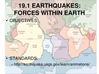
Earthquakes • An earthquakeis the vibration of Earth produced by the rapid release of energy within the lithosphere. • Earthquakes are produced by slippage along a break in the lithosphere called a fault.
Earthquakes • The point within the earth where the earthquake starts is called the focus. The focus of an earthquake is located along a fault underneath the surface. • The energy released by the earthquake travels in all directions from the focus in the form of seismic waves. These waves are similar to the waves produced when a stone is dropped in a pond.
Earthquakes • When you see a news report about an earthquake, the reporter always mentions the place on the Earth’s surface where the earthquake was centered. • This place is referred to as the epicenter. • The epicenter is the location on the surface directly above the focus.
Earthquakes • The movement that occurs along faults during earthquakes is a major factor in changing the surface above. • The land above a fault can shift tens of meters in a single earthquake. • Over time, this type of movement can push up coastlines, mountains, and plateaus.
Earthquakes • The crust can move vertically or horizontally as a result of fault movements. • If the crust moves vertically, scientists say it has been uplifted. Vertical movements create a sharp edge called a fault scarp. • If the crust moves horizontally we say it has been offset or displaced.
Earthquakes • The San Andreas fault: • The San Andreas fault in California is one of the most studied fault systems in the world. • This fault extends about 1300 kilometers through the state and into the Pacific ocean. • Studies have shown that displacement has occurred along the fault in areas as much as 200 kilometers long.
Earthquakes • The San Andreas fault: • The San Andreas fault is 1300 kilometers long but segments of it 100 to 200 kilometers long tend to act individually. • Some segments show a slow, gradual slip known as fault creep. Other sections regularly slip and produce small earthquakes. • Some segments remain unmoved for hundreds of years and then move suddenly with explosive force producing large earthquakes,
Earthquakes • The San Andreas fault: • One great earthquake along the fault was the San Francisco Earthquake of 1906. • During this earthquake, the land on the western side of the fault moved 4.7 meters in relation to the land on the east.
Earthquakes • Before the San Francisco Earthquake, scientists did not understand what caused them. Studies afterward led to the development of a hypothesisthat explained earthquakes. • According to the elastic rebound theory, most earthquakes are produced by the rapid release of energy stored in rock that has been subjected to great forces. • When the strength of the rock is exceeded, it suddenly breaks, releasing some of it’s energy as seismic waves.
Earthquakes • Deformation of Rock: • Forces inside the earth slowly deform the rock that makes up the Earth’s crust, causing the rock to change it’s shape. • As the rocks bend, they store energy, just as a wooden ruler does when you bend it. Elastic energy is the same kind of energy that is stored when you stretch a rubber band. • As the rock is stretched farther, as each side of the fault moves in an opposite direction, the elastic energy builds as tension in the rock increases.
Earthquakes • Deformation of Rock: • Suddenly the tension becomes too much; the rock slips at it’s weakest point,(the focus of an earthquake) releasing the energy. • Like a rubber band snapping, the energy is released in a moment along the fault line. • The tendency for the rock under pressure to spring back after an earthquake is calledelastic rebound. • The energy released from the elastic rebound moves along the fault line releasing the pent up energy as seismic waves.
Earthquakes • Aftershocks and Foreshocks: • Even a major earthquake like the 1906 earthquake does not release all the energy in one moment. • Aftershocks and foreshocks also release some of the fault’s stored elastic energy. • An aftershockis an earthquake that occurs sometime after a major earthquake. • Aftershocks may occur anywhere from hours to weeks after an earthquake. • Small earthquakes called foreshockssometimes precede major earthquakes days or even a year before a large event.
Earth Science 8.2 Measuring Earthquakes Measuring Earthquakes
Earth Science 8.2 Measuring Earthquakes • In 2003, a powerful earthquake shook Alaska wilderness south of Fairbanks along the Denali front. This earthquake was so strong it shook ponds in Louisiana and Texas. • Seismic waves carry the energy released from an earthquake hundreds of kilometers away. • Seismic waves transmit the energy of these vibrations from particle to particle. Like a bell hit with a hammer, the vibrations ring through the rocks the bedrock that makes up the lithosphere.
Earth Science 8.2 Measuring Earthquakes • Earthquakes produce two main types of seismic waves • Body waves • Surface waves • These seismic waves differ in • their type of wave motion, • their behavior as they travel through the Earth, • and their speed. • The waves that travel through the Earth’s interior are called body waves. • There are two types of body waves • P waves • S waves
Earth Science 8.2 Measuring Earthquakes • P waves and S waves: • P wavesare push-pull waves that push and pull particles as they move in a direction. They could also be said to compress-expand. • P waves are also called compressional waves. P waves travel faster than S waves. P waves can travel through both liquids and solids. • S wavesshake particles at right angles to the waves direction. Like taking one end of a rope and shaking it, the waves move in a curve. S waves are also called transverse waves.
Earth Science 8.2 Measuring Earthquakes • Surface waves: When body waves reach the surface, they produce surface waves. Surface waves travel more slowly than body waves do. • Surface waves move up and down as well as side-to-side. • Surface waves are usually much larger than body waves, so surface waves are usually the most destructive seismic waves.
Earth Science 8.2 Measuring Earthquakes • Recording Seismic Waves: • Scientists have developed an instrument to record seismic waves: the seismograph. • A seismograph produces a time record of the ground motion during an earthquake. • How it works: A seismograph has a weight suspended from a support that is attached to the bedrock. • When seismic waves reach the bedrock, the inertia of the suspended weight keeps the weight arm almost stationary while the bedrock moves. • In older seismographs, a pen suspended drew on a rotating cylinder and the traces showed the movement of the waves.
Earth Science 8.2 Measuring Earthquakes • Seismogram: • The time record that a seismograph produces is called a seismogram. • A seismogram shows all three types of seismic waves. • The stronger the earthquake, the larger the waves on the seismogram. • The first wave to arrive is the P wave, followed soon after by the S wave. • After the S waves, the Surface waves arrive showing much stronger movement. seismogram seismograph
Measuring Earthquakes: Richter Scale • Intensityis a measure of the amount of earth shaking that happens at a given location in an earthquake. • Magnitude(M) is a measure of the size of the seismic waves or the amount of energy released at the source of the earthquake. • The Richter Scale and the Moment Magnitude Scale both measure earthquake’s magnitude. • The Modifed Mercalli Scale is based on earthquake intensity. seismogram seismograph
Measuring Earthquakes: Richter Scale • Richter Scale: • A familiar but outdated scale for measuring the magnitude of earthquakes is the Richter Scale. • The Richter Scale is based on the height of the largest seismic wave (P,S, or surface wave) recorded on a seismograph. • A 10X increase in wave height equals an increase of 1 on the Richter Scale. • An increase for a M5.0 earthquake is 10 times greater than the shaking produced by a magnitude 4.0 on the Richter Scale. seismogram
Measuring Earthquakes: Momentary Magnitude Scale • Moment Magnitude Scale: • Today scientists use the moment magnitude scale to measure earthquakes. • The moment magnitude scaleis derived from the amount of displacement that occurs along a fault. • The moment magnitude scale is also the only scale that estimates the energyreleased by earthquakes.
Measuring Earthquakes: Momentary Magnitude Scale • Moment Magnitude Scale: • The moment magnitude is generated using several factors in addition to seismographic data. • These factors include • Average amount movement • Area of surface break • Strength of the broken rock • Together, these factors give a measure of how much energy is released when the rock slips and breaks and releases it’s energy as an earthquake.
Measuring Earthquakes: Modified Mercalli Scale • Modified Mercalli Scale: • Another scale used to rate earthquakes is the modified Mercalli scale. • This scale rates an earthquake’s intensity in terms of an earthquake’s effects at different locations (how much shaking it creates or damage it does). • The scale has 12 steps expressed as Roman numerals An earthquake that is barely felt rates a I. An earthquake which creates almost total destruction rates a XII • The same earthquake can rate different Mercalli scale ratings at different locations.
Measuring Earthquakes: Locating an Epicenter P waves S Waves • Locating an Earthquake Epicenter: • The difference in speeds between the P and the S waves provides a way to locate the epicenter. • The P wave always travels faster, arriving before the S wave. • The longer the distance away the epicenter, the greater the amount of time between the waves arriving.
Measuring Earthquakes: Triangulation • Locating an Earthquake Epicenter: • With this information, a receiver can judge the distance to the epicenter of the earthquake. • If multiple receiving stations ( 3 or more) at different spots on the globe can all identify and coordinate their information, they can triangulatea location. Each station knows it’s distance to the epicenter. • Triangulatemeans to use three or positions to determine an exact location.
Measuring Earthquakes: Time Travel Graphs • Locating an earthquake epicenter: • A time travel graph , data from seismographs from at least three different locations, and a globe can be used to determine an earthquakes epicenter. • First, using the data from the each of the seismograph readings, you estimate the distance from each receiver to the epicenter. • Second, you determine a circle from each receiver that shows the distance away the epicenter could be in any direction. • Third, the point where all three circles intersect marks the epicenter
Vocabulary: Earthquakes • Focus: the point beneath Earth's surface where rock that is under stress breaksEpicenter: point directly above the focusSeismic waves: vibrations that travel through Earth's surface carrying the energy created by an earthquakePrimary waves: the earthquake waves that compress and expand the ground like an accordionSecondary waves: the waves that vibrate from side to side as well as up and downSurface waves: when Primary waves and Secondary waves reach the surface some of them are transformed into Surface wavesSeismograph: the instrument that geologist use to record and measure the vibration of seismic waveMagnitude: the measurement of earthquake strength based on seismic waves and movement a long faultsMercalli Scale: rate earthquakes by their intensityRichter Scale: rate earthquakes by mechanical seismographMoment Magnitude Scale: rates earthquakes by estimating the total energy released