Download
1 / 26
270 likes | 481 Views
The Future of GNSS for Space Weather Monitoring and Research. Patricia H. Doherty Institute for Scientific Research Boston College. Expert Meeting on Improving Space Weather Forecasting in the Next Decade Vienna, Austria 10 February 2014. Outline. Historical perspective (before GPS)

E N D
The Future of GNSS for Space Weather Monitoring and Research Patricia H. Doherty Institute for Scientific Research Boston College Expert Meeting on Improving Space Weather Forecasting in the Next Decade Vienna, Austria 10 February 2014
Outline • Historical perspective (before GPS) • Research capabilities with GPS • Perils of GPS • Future Improvements • Multi-constellations • Multi-frequencies • New signals • What lies ahead…
Historical Measurements Geomagnetic Storm of March 1989 Single point measurements from faraday rotation of signals from geostationary satellites
Measurements of Halloween 2003 Storm Distributed networks of sensors yield global physics unattainable with single-point measurements Example : Global GPS-derived ionospheric mapping during geomagnetic disturbances [Coster et al, 2003]
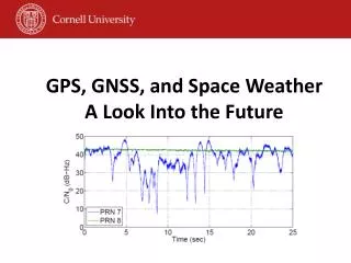
GPS Satellite Signals for Space Weather Monitoring/Research – not without problems Horizontal DGPS and WAAS Position Errors Halloween Storms 2003 • Space Weather has impacts on GPS: • Reduced accuracy - position errors due to large gradients • Reduced availability and continuity due to loss of lock, cycle slips and scintillation • Reduced integrity? S. Skone, 2012
GPS Satellite Signals for Space Weather Monitoring/Research – not without problems Ascension Island (7.98S, 345.59E) 16 Mar 2002 • Space Weather has impacts on GPS: • Reduced accuracy - position errors due to large gradients • Reduced availability and continuity due to loss of lock, cycle slips and scintillation • Reduced integrity?
GREAT NEWS! New Satellite Systems and Signals are on the way • Should Enable Improved: • Accuracy • Availability (with improved interference rejection) • Integrity • Continuity GPS Block III Satellite -Source: Lockheed-Martin.
Galileo (EU) GLONASS Beidou/COMPASS (China) GNSS Systems - Compatible and Interoperable Global Positioning System (GPS)
GNSS Constellations • Global Positioning System (GPS) • GLObal'nayaNAvigatsionnayaSputnikovayaSistema (GLONASS) • GALILEO • BeiDou/COMPASS • Quasi-Zenith Satellite System (QZSS) • Indian Regional Navigation Satellite System (IRNSS) • Satellite-based Augmentation System (SBAS)
Global Positioning System (GPS) • U.S. satellite navigation system • Program began in early 1970’s • First launch in 1978 • Declared fully operational in 1995 • Nominal 24-satellite constellation • ~20,200 km altitude • 55 degree inclination • 6 orbital planes • Now 31 operational satellites GPS Block IIR-M Satellite Source: Lockheed-Martin.
GPS Signal Evolution L5 L2 L1 C/A P(Y) P(Y) Legacy Signals L1C C/A L2C Signals After Modernization M M P(Y) P(Y) 1176.45 MHz 1227.6 MHz 1575.42 MHz C. Hegarty, MITRE, May 2013
GLONASSGLObal'nayaNAvigatsionnayaSputnikovayaSistema • Russian satellite navigation system • First launch in 1982 • Nominal 24-satellite constellation • 19,100 km altitude, 3 planes • Fully populated in 1995… • …but then deteriorated to as low as 7 • Now fully replenished – 24 operational satellites milestone reached in December 2011 • Next Generation • 4 new civil signals • 2 new frequencies Source: Russian Federation.
GALILEO • European contribution to the GNSS • Jointly managed by European Commission (EC) and European Space Agency (ESA) • Program gained significant boost in March 2002 with release of ~$1.1B euro • 30 satellite constellation • 3-planes • 56 deg inclination • ~23,200 km altitude • Two test satellites launched in 2005, 2008 • No longer operating • In-orbit validation (IOV) satellites: Oct 2011 (2), Oct 2012 (2) • Expecting Full Operational Capability in 2018 Source: European Space Agency.
BeiDou (COMPASS) • Chinese satellite navigation system • Final constellation planned to include: • 27 satellites in medium Earth orbit (MEO) • 55 degree inclination, ~21,500 km altitude • 5 satellites in geostationary orbit (GEO) • 3 - 5 satellites in inclined geosynchronous orbit (IGSO) • Launches: • Four experimental GEOs: 2000 (2), 2003, 2007 • MEOs: 2007, 2012 (4) • GEOs: 2009, 2010 (3), 2012 (2) • IGSOs: 2010 (2), 2011 (3) • Providing regional service in Dec 2012 (BeiDou) • Global Coverage ~2020 (COMPASS)
Quasi Zenith Satellite System (QZSS) Asian and Pacific Region • Japanese system • Plan calls for four satellites initially • Three highly elliptical ~36,000 km altitude orbits • One geostationary • Eventual growth to 7 satellites (design to-be-determined) • First satellite launched September 2010 (Michibiki) • 4 satellite system operational in 2018 Source: Japan Aerospace Exploration Agency.
Indian Regional Navigation Satellite System (IRNSS) • Indian regional system • Final constellation planned to include: • 3 satellites in geostationary orbit (GEO) • 4 satellites in inclined GSO • First Geo launched in July 2013 • Full implementation in 2016 Source: Indian Space Research Organization.
TheFAA Wide Area Augmentation System (WAAS) Designed to improve GPS accuracy, availability and integrity. • Current Infrastructure: • 38 Reference Stations • 3 Master Stations • 6Uplink stations • 3 Geostationary Satellites Courtesy of the FAA • WAAS message provides: • corrections for satellite orbits, time and the ionosphere • estimates of the uncertainty of those corrections • Future primary means of civil air navigation • For all aircraft in all phases of flight • Non-Precision Approach (NPA) – en-route • Vertically Guided Approach (LPV) – runway • First of many worldwide systems
Other Satellite-based Augmentation Systems (SBAS) • Europe: European Geostationary Navigation Overlay Service (EGNOS) • Operational - three satellites • Japan: Multifunctional Transport Satellite (MTSAT)-based Augmentation System (MSAS) • Operational - two satellites • India: GPS and GEO Augmented Navigation (GAGAN) • Not yet operational - 2 satellites in orbit • Russia: System of Differential Correction and Monitoring (SDCM) • Not yet operational - 1 satellite in orbit
Current and Future Satellites • GNSS now includes 87 satellites (plus associated ground networks) • More than 150 satellites anticipated within a decade C. Hegarty, MITRE, May 2013
GNSS Signal Evolution L1 L5 L2 GPS (US) Future CDMA signal GLONASS (Russia) Galileo (Europe) COMPASS (China) IRNSS (India) QZSS (Japan) SBAS (US Europe India Japan) Compass & IRNSS In S-band 23 C. Hegarty, MITRE, May 2013
Future of GNSS for Space Weather Research • Multi-constellation/Multi-frequency GNSS • Improves performance • Operational benefits (safety in applications) • Reduced loss of service • Increased coverage area • Range delay errors will essentially disappear once dual-frequency signals are available to civil users • Scintillation is not going away…… • Although frequency diversification may be very effective • L5 (1176.45 MHz) should be somewhat more sensitive to scintillation than L1 (1575.MHz), but the signal will be stronger than L1 • Building robustness in receiver design is most important • Education, equipment and measurements are needed for research and applications
Summary We’ve come a long way in space weather research with GNSS. Great things yet to come! Courtesy, P. Enge
Thank you for your attention! Patricia H. Doherty Patricia.Doherty@bc.edu Phone: 617-552-8767 Fax: 617-552-2818 http://www.bc.edu/isr