Download
1 / 7
70 likes | 226 Views
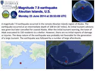
Magnitude 7.9 earthquake Aleutian Islands, U.S. Monday 23 June 2014 at 20:53:09 UTC.

E N D
Magnitude 7.9 earthquake Aleutian Islands, U.S. Monday 23 June 2014 at 20:53:09 UTC • A magnitude 7.9 earthquake occurred in the remote Aleutian Islands region of Alaska. The earthquake occurred at an intermediate depth of 108 km (67 miles). An initial tsunami advisory was given but later cancelled for coastal Alaska. After the initial tsunami warning, the town of Adak evacuated its 150 residents to a shelter. However, there are no initial reports of damage or injuries. The deep nature of the earthquake was probably not favorable for the generation of a large tsunami. The earthquake was followed by a number of large aftershocks.
Magnitude 7.9 earthquake Aleutian Islands, U.S. Monday 23 June 2014 at 20:53:09 UTC Where was the earthquake felt? The Modified-Mercalli intensity scale indicates the severity of ground shaking. Strong shaking(VII) would have been felt throughout the Rat Islands area of the Aleutian Islands, although due to the minimal population density in the region, this strong shaking was unlikely to have been felt by many people. USGS estimated shaking intensity in the region of the M7.9 earthquake Modified Mercalli Intensity Scale
Magnitude 7.9 earthquake Aleutian Islands, U.S. Monday 23 June 2014 at 20:53:09 UTC Past earthquakes in the region The Aleutian Islands is a very seismically active region. Since 1900, 26 earthquakes with M7 or greater occurred within 250 km of the 2014 earthquake hypocentre. Significant events include an M 8.4 quake in 1965 and a M 7.9 quake in 1996. The former generated a large tsunami across the Pacific Ocean. There was also a M8.4 earthquake in 1906. Most of these large earthquakes occurred at shallower depths than the June 23 event. Historic seismicity (since 1970) showing magnitudes of greater than 5.5 in the region. Earthquakes are coloured by their hypocentral depth. The Jun 2014 earthquake epicentre is indicated by the red star. Earthquake locations from the USGS catalogue.
Magnitude 7.9 earthquake Aleutian Islands, U.S. Monday 23 June 2014 at 20:53:09 UTC What caused this earthquake to occur? The Aleutian Islands region is seismically active due to the northward subduction (59 - 76 mm/yr) of the Pacific plate into the mantle beneath the North America plate along an arc-shaped plate boundary. This underthrusting process is responsible for the formation of the Aleutian Islands and the deep-sea Aleutian trench. The strongest earthquakes in subduction zones normally occur along the shallow megathrust fault due to slip along the interface that separates two plates. Based on its mechanism and depth, the 23 June earthquake likely occurred as a result of extension within the subducting Pacific slab. USGS focal mechanism of the earthquake indicating oblique normal faulting. Tectonic setting of the central Aleutian region. The 23 June earthquake is given by the red star. North America plate Schematic illustration of oblique-normal faulting. Aleutian Trench For more information on Alaska and Aleutian Island tectonics, see this YouTube video: https://www.youtube.com/watch?v=2nMiVd0zo_Y 73 mm/yr Pacific plate
Magnitude 7.9 earthquake Aleutian Islands, U.S. Monday 23 June 2014 at 20:53:09 UTC Aftershocks So far, over 20 aftershocks with magnitude greater than 4.0 have been recorded by the USGS. Most of these have been small (M < 5), but the largest aftershock was a magnitude 6.6 earthquake that occurred around six hours after after the mainshock. Most aftershocks have so far occurred to the north-west of the mainshock epicentre. Further moderate-sized aftershocks can be expected. M6.6 aftershock M7. 9 mainshock Map of aftershocks recorded (orange circles).
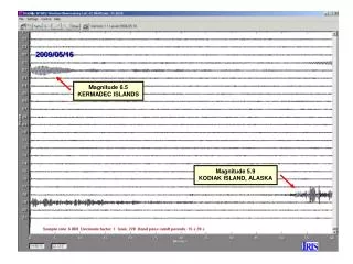
Magnitude 7.9 earthquake Aleutian Islands, U.S. Monday 23 June 2014 at 20:53:09 UTC Recordings of the earthquake from the British Geological Survey seismometer network Time of earthquake First P-wave arrivals Surface wave arrivals The first seismic waves took ~13 minutes to travel from Alaska and arrive in the UK
Magnitude 7.9 earthquake Aleutian Islands, U.S. Monday 23 June 2014 at 20:53:09 UTC Find out more … • USGS webpage for this earthquakes: http://earthquake.usgs.gov/earthquakes/eventpage/usc000rki5#summary • Alaska earthquake center: http://www.aeic.alaska.edu • BGS (British Geological Survey) – seismology and earthquakes – frequently asked questions http://www.earthquakes.bgs.ac.uk/education/faqs/faq_index.html • IRIS (Incorporated Research Institutions for Seismology) – learning about earthquakes http://www.iris.edu/hq/programs/education_and_outreach/students • UK School Seismology Project – classroom activities, videos and support documents http://www.bgs.ac.uk/schoolseismology/home.html • USGS (United States Geological Survey) – FAQs, glossary, posters, animations http://earthquake.usgs.gov/learn/ • EMSC (European Mediterranean Seismological Centre) http://www.emsc-csem.org/