Download
1 / 34
340 likes | 512 Views
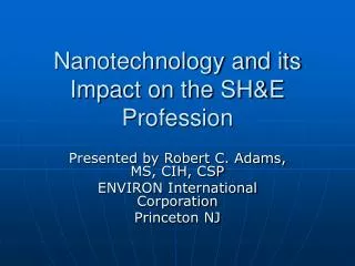
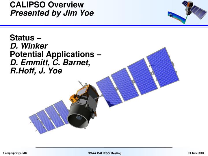
CALIPSO Overview Presented by Jim Yoe Status – D. Winker Potential Applications – D. Emmitt, C. Barnet, R.Hoff, J. Yoe. CALIPSO. Star Tracker Assembly. Wide Field Camera. Lidar Transmitter Assembly. Imaging Infrared Radiometer. Three co-aligned instruments: CALIOP

E N D
CALIPSO Overview Presented by Jim Yoe Status – D. Winker Potential Applications – D. Emmitt, C. Barnet, R.Hoff, J. Yoe
CALIPSO Star Tracker Assembly Wide Field Camera Lidar Transmitter Assembly Imaging Infrared Radiometer • Three co-aligned instruments: • CALIOP • (3-channel lidar) • 532 nm|| • 532 nm^ • 1064 nm • Imaging IR radiometer • Wide-Field Camera Aerosol and cloud - Layer heights - b and s profiles Cloud ice/water phase, IWC Cloud emissivity Ice particle size
Lidar Block Diagram Features: Analog detection • 532 nm: PMT’s • 1064 nm: APD 22-bit dynamic range Active boresight adjustment Lidar calibration: - 532║ – normalization of molecular return - 532┴ – relative to 532║ using on-board cal H/W - 1064 – relative to 532T using cirrus backscatter
Instrument Specifications CALIOP Wide-Field Camera (WFC) Imaging Infrared Radiometer (IIR)
Atmospheric Test Lidar atmospheric testing was conducted in Boulder, Colorado from Dec 7 through Dec 11, 2003. • No problems encountered • Lidar performance was outstanding on all tests.
CALIPSO CloudData from 12/08/03 Signal Average 14.5 to 24.4 km Signal Average 4.6 to 14.5 km
Comparison of CALIPSO and Co-Lidar Profiles CALIPSO and the co-lidar show reasonable agreement for cloud altitudes, depolarization ratio, and profile shapes. Further study is needed to sort out some issues with time tags and data resolution.
Clear Air Profile Results: Depolarization Ratio Measurement • The measured clear air depolarization ratio is < 0.7%. • The true value should be < 0.4%. • The difference between the measured and true value sets an upper limit on the amount of crosstalk between the polarization channels. • The requirement is less than 1.0% crosstalk. This measurement indicates that the actual crosstalk is less than half of that.
Payload Integrated to Platform • Payload-platform mech. integration 1 Mar 2004 • Satellite Performance Verification Test completed 26 March • Conducted E-M Compatibility (EMC) completed 9 April • Satellite Sine-Vibe to finish today • Satellite T/V - August
Upcoming Milestones • ASDC/DMS Launch Readiness Review (LRR) October 2004 • Flight Ops Review (FOR) December 2004 • Satellite ships to VAFB January 2005 • Launch 15 April 2005 • First lidar profiles 1 June 2005 • Prelim data release 1 Sept 2005
CALIPSO Mission Objectives • CALIPSO will fly as part of the Aqua constellation (A-train) to provide observations needed to improve: • The representation of aerosols and clouds in models • Improved climate predictions • Improved models of atmospheric chemistry • Our understanding of the role of aerosols and clouds in the processes that govern climate responses and feedbacks • – Direct and indirect aerosol effects • – Cloud forcing and feedbacks
Synergies with the A-train The atrain thick clouds drizzle aerosol profiles, cloud tops polarization, multi-angle CERES: TOA fluxes MODIS: cloud re, t AMSR: LWP O2 A-band OMI – absorbing aerosol Orbit: 705 km, 98° inclination, 1:30 PM equator crossing
Aerosols: The Most Uncertain External Climate Forcing Agent In contrast to greenhouse gases, aerosols: - are shortlived, spatially inhomogenous, interact strongly with clouds - composition highly variable, heterogen. chemistry poorly understood (IPCC, 2001)
Objective for CALIPSO Beyond Climate • Application to design and subsequent operations of future DIAL and Doppler wind lidars (DWL) • Analysis & Improvement of current CTWs • Application to Radiometric Sounders and NWP
CALIPSO Influences on DWL • CFLOS probabilities by height in atmosphere; by synoptic situation; by wind shear classification. • Probabilities of contiguous CFLOSs for shot integrating lidars • Nature of multiple cloud layer impacts on lidar data utility • General global distribution of aerosols (355– 2000nm); vertical, horizontal, hemispherical, etc. • Need CFLOS and backscatter statistics for evaluating the realism of Nature Runs used in NCEP and NASA OSSEs
CALIPSO Influence on CTWs • Height Assignment Validation • Extend/Collaborate with John Reagan, others • Impact Assessment of Improved Height Assignment on NWP • Need a warm body equipped with a sharp mind
CALIPSO Influence on Conventional Sounders & NWP • AIRS, MODIS • Compare/Validate Products – Cloud Cleared Radiances • Problems with CCRs in lowest 1-2 km, require external QA • CALIPSO to benefit from external data (AIRS/AMSU) @ 20 km • Results Applicable to Subsequent Sensors • IASI, CrIS, VIIRS, GOES/ABI, etc.
Aerosol backscatter • DWLs at 2, 1.06 and .355 microns • Can use models to estimate backscatter at wavelengths near CALIPSO’s • Interest in nature of elevated layers; thickness, relationship to wind shear, variability in height over individual feature • Dynamic range of Beta within entire tropospheric column.
Summary • CALIPSO promises to provide a data set critical for design trade studies of future space-based lidars • CALIPSO will provide data to increase impact of current satellite sensors for NWP • May refine requirements for DWL • DWL community should look forward to a successful CALIPSO mission that lowers the risk (and thus $$) for follow-on active optical remote sensing from space.
Background • LITE provided early insight into cloud vertical distributions and CFLOS statistics • SLA provided very limited, but useful CFLOS statistics • ICESat promises to expand on the LOS statistics and estimates of global aerosol backscatter distributions.
The Vertical: CALIPSO Aerosol Aerosol Direct Radiative Forcing • CALIPSO aerosol profiles - aerosol lifetime dependent on height - radiative effects depend on underlying reflectance - observe aerosol above cloud, below thin cirrus • A-train: CALIPSO + MODIS + CERES - improved characterization of direct forcing Cirrus Aerosol Indirect Radiative Forcing • CALIPSO cloud and aerosol profiles - unique ability to determine if cloud and aerosol are in the same layer. • A-train: add MODIS + CERES - cloud microphysics, optics, radiation • A-train: add AMSR, Cloudsat radar - adds LWP plus drizzle. Low Cloud Sahara dust
Depolarization Observations of Asian Dust Backscatter profiles Depolarization profiles provide information on aerosol type and aid in discrimination of aerosol and cloud Depolarization profiles Figure courtesy of T. Murayama
The Vertical: CALIPSO/Cloudsat Cloud Layering LW Surface Radiative Fluxes - Vertical distribution of multilayered clouds - Polar clouds: coverage, height LW & SW heating/cooling rates - multilayer cloud structure and thickness CALIPSO - 80% penetration to top of boundary layer • A-train add CloudSat radar - adds profiles of deep convective clouds LW Cloud Radiative Forcing • The threshold temperature dividing mixed-phase and ice clouds is not well known • Ice/water partitioning is an important modulator of the climate sensitivity in climate models • Unique CALIPSO observations - improved ice/water phase, vertically resolved - IWP for thin cloud, Cloudsat for moderate/thick - IR particle size retrievals constrained by lidar cloud height and depolarization (Fowler and Randall, 1996: J. Clim. 9, 561)
Combined lidar/radar sensing of cloud CRYSTAL-FACE, 23 July 2003 CPL lidar backscatter CRS radar reflectivity CPL+CRS composite GOES visible
Color ratios improve cloud/aerosol separation Integrated attenuated backscatter, ’
Aerosol Retrievals: MODIS vs. CALIPSO • Uncertainties in ta are due to Sa (mostly) and calibration (slightly) • lidar excels at low optical depth: t < 0.2 • complements passive capabilities Impact of error in Sa Impact of calibration error