Download
1 / 3
0 likes | 38 Views
Point Cloud to CAD and Scan to BIM work synergistically to facilitate a comprehensive and accurate digital representation of physical structures in the realms of architecture and construction. Point Cloud to CAD serves as the initial bridge between the real world and the digital environment, converting laser-scanned or LiDAR-derived point cloud data into a usable CAD format. This technique ensures precise geometric representation, laying the foundation for subsequent design modifications. Scan to BIM takes this a step further by infusing intelligence into the CAD models. RVTCAD

E N D
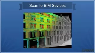
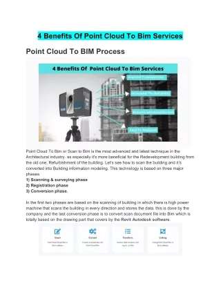
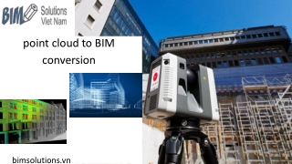
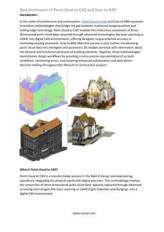
Best techniques of Point cloud to CAD and Scan to BIM Introduction: In the realm of architecture and construction, Point Cloud to CAD and Scan to BIM represent innovative methodologies that bridge the gap between traditional design practices and cutting-edge technology. Point Cloud to CAD involves the meticulous conversion of three- dimensional point cloud data, acquired through advanced technologies like laser scanning or LiDAR, into digital CAD environments, offering designers unprecedented accuracy in recreating existing structures. Scan to BIM takes this process a step further, transforming point cloud data into intelligent and parametric 3D models enriched with information about the physical and functional attributes of building elements. Together, these methodologies revolutionize design workflows by providing a more precise representation of as-built conditions, minimizing errors, and fostering enhanced collaboration and data-driven decision-making throughout the lifecycle of construction projects. What is Point cloud to CAD? Point Cloud to CAD is a transformative process in the field of design and engineering, seamlessly integrating the physical world with digital precision. This methodology involves the conversion of three-dimensional point cloud data, typically captured through advanced surveying technologies like laser scanning or LiDAR (Light Detection and Ranging), into a digital CAD environment. www.rvtcad.com
The point cloud, which consists of millions of individual data points representing surfaces and objects within a physical space, serves as a highly detailed and accurate reference. CAD software then processes and interprets this raw point cloud data, allowing designers, architects, and engineers to create precise digital representations of existing structures or environments. This process not only facilitates the preservation of accurate as-built conditions but also empowers professionals to streamline design workflows, reduce errors, and enhance overall efficiency in the creation of digital models for architectural, engineering, and construction purposes. Point Cloud to CAD has become an indispensable tool, offering unparalleled accuracy and a solid foundation for informed decision-making in diverse industries. Techniques of point cloud to CAD: •Data Acquisition and Processing •Registration and Alignment •Feature Extraction •Meshing and Surface Reconstruction •Modeling Techniques •Quality Control and Validation •Integration with CAD Software •Collaboration and Documentation Scan to BIM: Scan to BIM, an innovative process at the intersection of advanced surveying technologies and Building Information Modeling (BIM), transforms point cloud data obtained through 3D laser scanning or LiDAR into intelligent and parametric 3D models. Beginning with meticulous data alignment and registration to ensure precision, Scan to BIM employs classification and object recognition algorithms to automatically identify and label structural elements within the point cloud. Parametric modeling adds a dynamic dimension, allowing for the creation of intelligent models that adapt to design changes. The management of the level of detail (LOD), interoperability with various software applications, clash detection, and resolution contribute to a streamlined construction process. Additionally, the integration of asset information, thorough documentation, and regular model updates make Scan to BIM a powerful tool not only for design and construction but also for ongoing facility management. Overall, Scan to BIM enhances collaboration, reduces errors, and provides a comprehensive digital representation of the physical environment throughout the project lifecycle. Techniques of Scan to BIM: The Scan to BIM process employs a series of techniques to seamlessly transform point cloud data into an intelligent Building Information Model (BIM). Beginning with the meticulous alignment and registration of multiple scans, the data undergoes cleanup and filtering to eliminate noise and enhance accuracy. Advanced algorithms for classification and object recognition automatically identify and label architectural and structural elements within the point cloud, streamlining the modeling workflow. Parametric modeling introduces intelligence to the BIM model, allowing for dynamic properties and adaptability to design changes. www.rvtcad.com
Level of Detail (LOD) management ensures that the model provides the necessary information for each project phase. Interoperability with BIM software enhances collaboration, while clash detection and resolution identify and address potential conflicts early in the design process. The integration of asset information, thorough documentation, and regular model updates contribute to a comprehensive BIM model that not only represents the physical structure but also serves as a valuable tool for construction and facility management. How they work together point cloud to CAD and Scan to BIM? The Scan to BIM process employs a series of techniques to seamlessly transform point cloud data into an intelligent Building Information Model (BIM). Beginning with the meticulous alignment and registration of multiple scans, the data undergoes cleanup and filtering to eliminate noise and enhance accuracy. Advanced algorithms for classification and object recognition automatically identify and label architectural and structural elements within the point cloud, streamlining the modeling workflow. Parametric modeling introduces intelligence to the BIM model, allowing for dynamic properties and adaptability to design changes. Level of Detail (LOD) management ensures that the model provides the necessary information for each project phase. Interoperability with BIM software enhances collaboration, while clash detection and resolution identify and address potential conflicts early in the design process. The integration of asset information, thorough documentation, and regular model updates contribute to a comprehensive BIM model that not only represents the physical structure but also serves as a valuable tool for construction and facility management. Conclusion: Point Cloud to CAD and Scan to BIM work synergistically to facilitate a comprehensive and accurate digital representation of physical structures in the realms of architecture and construction. Point Cloud to CAD serves as the initial bridge between the real world and the digital environment, converting laser-scanned or LiDAR-derived point cloud data into a usable CAD format. This technique ensures precise geometric representation, laying the foundation for subsequent design modifications. Scan to BIM takes this a step further by infusing intelligence into the CAD models. RVTCAD offering Point Cloud to CAD and Scan to BIM services utilize advanced laser scanning technology. They capture precise three- dimensional point cloud data of physical structures, then employ sophisticated software for data processing, object recognition, and parametric modeling. This process enhances design accuracy, collaboration, and decision-making throughout construction projects, ensuring a seamless transition from the physical to the digital realm. www.rvtcad.com